Oakland Plantation

Log in to your account

AroundUs is a community-driven map of interesting places, built by curious explorers like you. It grows with every review, story, and photo you share.
Connect to save your favorite spots, contribute locations, and create personalized routes.
Continue with Google
Continue with Apple
Continue with X
Continue with Facebook
Continue with email
By continuing, you accept our Terms and Conditions and our Privacy Policy
Create an account
Add to collection
Map
Suggest a change
Share

Oakland Plantation, Cotton plantation in Natchitoches Parish, Louisiana.

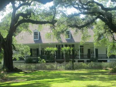
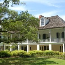
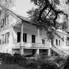
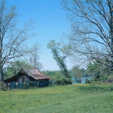
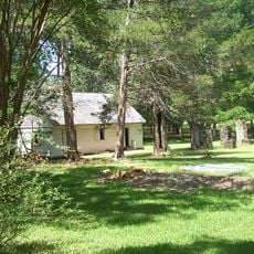
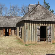
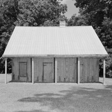
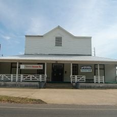
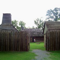
Oakland Plantation is a cotton plantation in Natchitoches Parish, Louisiana, with 17 original structures remaining from different periods of construction. The buildings include the main house, outbuildings such as pigeonniers, an overseer's dwelling, grain storage, and several workshops that together show how the property was organized and used.

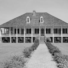
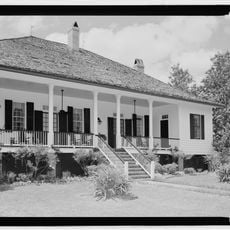
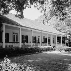
The main house was completed in 1821 by Jean Pierre Emanuel Prud'homme and Catherine Lambre, marking the start of one of the first cotton plantations in the region. Over the following decades, the plantation expanded with additional outbuildings and workshops that reflected the growing scale of operations.

The buildings are named after the different trades and crafts that took place within them, from blacksmithing to carpentry. These names reflect how specialized the work was and the diverse skills that people developed while living and working on the property.

The buildings are clustered closely together, making it easy to walk between them and see the entire layout of the property. Shade from mature trees provides relief during hot months, and the grounds are well-maintained with clear pathways connecting the different structures.

It was recognized as one of only two farms west of the Mississippi River to receive Bicentennial Farm status. This honor recognizes the continuity and longevity of agricultural use on the site across many generations.

Location: Natchitoches Parish

GPS coordinates: 31.66500,-93.00330

Latest update: December 10, 2025 16:30

Photos
Around this place
Melrose Plantation
United States of America

Melrose Plantation

8 km
Magnolia Plantation
United States of America

Magnolia Plantation

14.1 km
Los Adaes
United States of America

Los Adaes

27.9 km
Cane River Creole National Historical Park
United States of America

Cane River Creole National Historical Park

82 m
Oaklawn Plantation
United States of America

Oaklawn Plantation

952 m
Fort Jesup
United States of America

Fort Jesup

38.1 km
Black Lake
United States of America

Black Lake

32.8 km
Harry Turpin Stadium
United States of America

Harry Turpin Stadium

12.7 km
Fort St. Jean Baptiste State Historic Site
United States of America

Fort St. Jean Baptiste State Historic Site

12.6 km
Kate Chopin House
United States of America

Kate Chopin House

16.1 km
Cherokee Plantation
United States of America

Cherokee Plantation

4 km
Basilica of the Immaculate Conception
United States of America

Basilica of the Immaculate Conception

13.3 km
Rebel State Historic Site
United States of America

Rebel State Historic Site

12.3 km
Natchitoches Historic District
United States of America

Natchitoches Historic District

13 km
Narcisse Prudhomme Plantation
United States of America

Narcisse Prudhomme Plantation

844 m
Badin-Roque House
United States of America

Badin-Roque House

7.6 km
Caspiana Plantation Store
United States of America

Caspiana Plantation Store

14.7 km
Church of St. Anne
United States of America

Church of St. Anne

29.9 km
Robeline Methodist Church
United States of America

Robeline Methodist Church

28.7 km
City Hotel
United States of America

City Hotel

38 km
Old Courthouse Museum
United States of America

Old Courthouse Museum

13.4 km
Jones House
United States of America

Jones House

9.9 km
Fort St. Jean Baptiste
United States of America

Fort St. Jean Baptiste

12.6 km
Port of Natchitoches
United States of America

Port of Natchitoches

19.7 km
Natchitoches Parish Library
United States of America

Natchitoches Parish Library

27.2 km
Davis Springs Methodist Church
United States of America

Davis Springs Methodist Church

35.9 km
Bank of Montgomery Washington Street Branch
United States of America

Bank of Montgomery Washington Street Branch

13.5 km
Church Street Bridge
United States of America

Church Street Bridge

13.2 km
Show the full map
Reviews

Visited this place? Tap the stars to rate it and share your experience / photos with the community! Try now! You can cancel it anytime.

« Oakland Plantation - Cotton plantation in Natchitoches Parish, Louisiana » is provided by Around Us (aroundus.com). Images and texts are derived from Wikimedia project under a Creative Commons license. You are allowed to copy, distribute, and modify copies of this page, under the conditions set by the license, as long as this note is clearly visible.

Discover hidden gems everywhere you go!

From secret cafés to breathtaking viewpoints, skip the crowded tourist spots and find places that match your style. Our app makes it easy with voice search, smart filtering, route optimization, and insider tips from travelers worldwide. Download now for the complete mobile experience.

Around Us App Screenshot

A unique approach to discovering new places

Le Figaro

All the places worth exploring

France Info

A tailor-made excursion in just a few clicks

20 Minutes