Chest opened
+${chestReward.xp} XP
Explorer
NOUVEAU ×${chestReward.collectible.quantity}
tapez pour fermer
Chest locked

Open chests in the app

Around Us is built for your phone — chests unlock when you walk, explore and capture nearby places.

Enable Location

We need your location to show you interesting places around you

Discover nearby places

Find interesting locations and hidden gems around you

Precise directions

Get accurate directions and distances to places

Your location is never shared with other users. It's only used when you tap the location button.

Log in to your account

Start exploring — it's free

Trusted by 72,884 travelers worldwide

Continue with Google
Continue with Apple
or

We will send you a code to connect

By continuing, you accept our Terms and Conditions and our Privacy Policy

Check your inbox

We've sent a pincode in your inbox. Please enter the code below.

Ono Island
Discussion Reviews Photo
18.1k Popularity

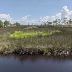
Ono Island, Private barrier island in Baldwin County, Alabama.

Ono Island is a barrier island located at the mouth of Perdido Bay in Alabama. The narrow strip of land measures about 5.5 miles long and sits between Bayou St. John to the north and Old River to the south.

The island once served as a boundary marker between the United States and Spain following the Louisiana Purchase under President James Monroe. It represented a significant line in the territorial definition of the young American nation in the region.

The residential community here has made environmental protection a priority in how they manage the land. Residents gather regularly to maintain their bonds and discuss shared interests in preserving the natural surroundings.

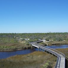
You can only reach the island by crossing a private guarded bridge from State Route 182, and you need permission from residents to enter. This restricted access means planning ahead is important if you want to visit.

The name came from a quirky land dispute between Florida and Alabama over contested territory between old and new river passes. When Florida tried to claim the disputed area, Alabama lawmakers responded with a playful objection.

The community of curious travelers

AroundUs brings together thousands of curated places, local tips, and hidden gems, enriched daily by 60,000 contributors worldwide.

Start exploring
Location
Elevation above the sea
2 m
GPS coordinates
30.29361,-87.49750
Latest update
December 7, 2025 19:23
Around this place
Fort Pickens
United States of America

Fort Pickens

20.2 km
National Naval Aviation Museum
United States of America

National Naval Aviation Museum

19.6 km
Fort Barrancas
United States of America

Fort Barrancas

20.1 km
Gulf State Park
United States of America

Gulf State Park

14.9 km
Gulf Shores Public Beach
United States of America

Gulf Shores Public Beach

20.7 km
Big Lagoon State Park
United States of America

Big Lagoon State Park

9.6 km
Alabama Gulf Coast Zoo
United States of America

Alabama Gulf Coast Zoo

17.4 km
Pensacola Light
United States of America

Pensacola Light

19.1 km
Barrancas National Cemetery
United States of America

Barrancas National Cemetery

21.4 km
Bamahenge
United States of America

Bamahenge

7.9 km
Tarkiln Bayou Preserve State Park
United States of America

Tarkiln Bayou Preserve State Park

12 km
Plaza Ferdinand VII
United States of America

Plaza Ferdinand VII

30.1 km
Pensacola City Hall
United States of America

Pensacola City Hall

29.7 km
Pensacola Naval Air Station Historic District
United States of America

Pensacola Naval Air Station Historic District

20.2 km
First National Bank Building
United States of America

First National Bank Building

30.1 km
St. Paul's Episcopal Church
United States of America

St. Paul's Episcopal Church

28.9 km
St. Mark's Lutheran Church
United States of America

St. Mark's Lutheran Church

16.8 km
St. Joseph's Church Buildings
United States of America

St. Joseph's Church Buildings

29.8 km
Mount Zion Missionary Baptist Church
United States of America

Mount Zion Missionary Baptist Church

29.7 km
Swift Presbyterian Church
United States of America

Swift Presbyterian Church

15.5 km
Bamahenge
United States of America

Bamahenge

7.9 km
Sunnyside Hotel
United States of America

Sunnyside Hotel

29.3 km
Allen House
United States of America

Allen House

23 km
Charles William Jones House
United States of America

Charles William Jones House

29.9 km
Brunell House
United States of America

Brunell House

29.4 km
National Naval Aviation Museum
United States of America

National Naval Aviation Museum

19.7 km
Flora-Bama
United States of America

Flora-Bama

2.4 km
Wade Ward Nature Park
United States of America

Wade Ward Nature Park

18.9 km
Show the full map
Reviews
Share your experience

No review yet

Discussions
Start a discussion...

No discussion yet

« Ono Island - Private barrier island in Baldwin County, Alabama » is provided by Around Us (aroundus.com). Images and texts are derived from Wikimedia project under a Creative Commons license. You are allowed to copy, distribute, and modify copies of this page, under the conditions set by the license, as long as this note is clearly visible.

Discover hidden gems everywhere you go!

From secret cafés to breathtaking viewpoints, skip the crowded tourist spots and find places that match your style. Our app makes it easy with voice search, smart filtering, route optimization, and insider tips from travelers worldwide. Download now for the complete mobile experience.

Around Us App Screenshot

A unique approach to discovering new places

Le Figaro

All the places worth exploring

France Info

A tailor-made excursion in just a few clicks

20 Minutes

Around Us
Travel Guide & Maps
Download

Send to your phone

QR Code
1

Open the camera app on your mobile.

2

Point at the QR code with your camera. A notification will appear.

3

Tap the notification to open the link.