Interstate 85

Log in to your account

AroundUs is a community-driven map of interesting places, built by curious explorers like you. It grows with every review, story, and photo you share.
Connect to save your favorite spots, contribute locations, and create personalized routes.
By continuing, you accept our Terms and Conditions and our Privacy Policy
Add to collection
Map
Suggest a change
Share

Interstate 85, Interstate highway system in southeastern United States.

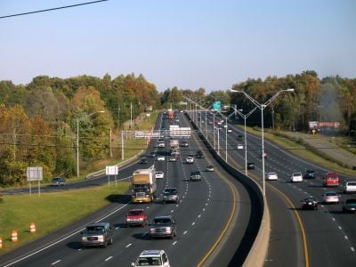
Interstate 85 is a highway in the southeastern United States that runs through five states from Montgomery, Alabama, to Petersburg, Virginia. The route passes through several major cities including Atlanta, Charlotte, and Greenville while crossing key transportation junctions.

Construction began in the late 1950s as part of the national highway program under President Eisenhower. Some sections replaced older toll roads and regional connecting routes that previously carried traffic between states.

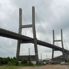
Residents often refer to sections by local names such as the Crescent Corridor, which ties together economic centers across multiple states. Commuters and long-haul drivers use the distinctive bridges crossing rivers like the Yadkin and Savannah as landmarks during their journeys.

Rest stops and fueling stations appear at regular intervals along the entire route through all five states. Lanes typically run two per direction, with some sections in metro areas offering additional lanes for heavier traffic.

A section in Georgia serves as a testing ground for experimental technologies such as solar panels embedded in the pavement and self-driving vehicles. This area is continuously monitored by research teams developing new solutions for roadway transportation.

Location: Virginia

Location: North Carolina

Location: South Carolina

Location: Georgia

Location: Alabama

GPS coordinates: 30.94162,-87.88470

Latest update: December 4, 2025 23:41

Around this place
Show the full map
USS Alabama
United States of America

USS Alabama

31.5 km
Africatown
United States of America

Africatown

28.4 km
Battleship Memorial Park
United States of America

Battleship Memorial Park

31.5 km
General W.K. Wilson Jr. Bridge
United States of America

General W.K. Wilson Jr. Bridge

8.1 km
RSA Battle House Tower
United States of America

RSA Battle House Tower

31.4 km
Mobile-Tensaw River Delta
United States of America

Mobile-Tensaw River Delta

21.6 km
Cochrane–Africatown USA Bridge
United States of America

Cochrane–Africatown USA Bridge

27.7 km
Bottle Creek Indian Mounds
United States of America

Bottle Creek Indian Mounds

9.2 km
Blakeley
United States of America

Blakeley

22.5 km
Meaher State Park
United States of America

Meaher State Park

30.7 km
Historic Blakeley State Park
United States of America

Historic Blakeley State Park

22.3 km
Mount Vernon Arsenal
United States of America

Mount Vernon Arsenal

21.3 km
Ellicott's Stone
United States of America

Ellicott's Stone

14.6 km
The Catholic Cemetery of Mobile
United States of America

The Catholic Cemetery of Mobile

31.5 km
Richards DAR House
United States of America

Richards DAR House

31.4 km
RSA–BankTrust Building
United States of America

RSA–BankTrust Building

31.5 km
Magee Farm
United States of America

Magee Farm

29.8 km
Aimwell Baptist Church
United States of America

Aimwell Baptist Church

31.4 km
John Archibald Campbell United States Courthouse
United States of America

John Archibald Campbell United States Courthouse

31.5 km
Chickasaw Shipyard Village Historic District
United States of America

Chickasaw Shipyard Village Historic District

27.3 km
First National Bank
United States of America

First National Bank

31.4 km
Coley Building
United States of America

Coley Building

31.4 km
Latham United Methodist Church
United States of America

Latham United Methodist Church

18.2 km
First Baptist Church
United States of America

First Baptist Church

12.1 km
Emanuel Building
United States of America

Emanuel Building

31.4 km
Montgomery Hill Baptist Church
United States of America

Montgomery Hill Baptist Church

26.3 km
Nelson House
United States of America

Nelson House

16.8 km
Davis-Oak Grove District
United States of America

Davis-Oak Grove District

30.2 km
Show the full map

Reviews

Visited this place? Tap the stars to rate it and share your experience / photos with the community! Try now! You can cancel it anytime.

« Interstate 85 - Interstate highway system in southeastern United States » is provided by Around Us (aroundus.com). Images and texts are derived from Wikimedia project under a Creative Commons license. You are allowed to copy, distribute, and modify copies of this page, under the conditions set by the license, as long as this note is clearly visible.

Discover hidden gems everywhere you go!

From secret cafés to breathtaking viewpoints, skip the crowded tourist spots and find places that match your style. Our app makes it easy with voice search, smart filtering, route optimization, and insider tips from travelers worldwide. Download now for the complete mobile experience.

Around Us App Screenshot

A unique approach to discovering new places

Le Figaro

All the places worth exploring

France Info

A tailor-made excursion in just a few clicks

20 Minutes