Talladega National Forest, National forest in Alabama, United States.
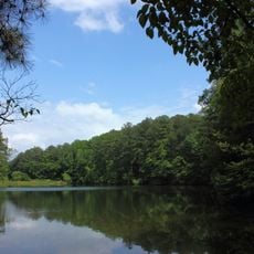
Talladega National Forest covers 392,567 acres at the southern edge of the Appalachian Mountains in Alabama. It is split into two separate areas and three ranger districts: Oakmulgee in the central state east of Tuscaloosa, and Shoal Creek and Talladega in the northeast. The districts differ in terrain, from broad ridges and floodplains to upland hills and low mountains.
The federal government bought the land that became Talladega National Forest in the 1930s, when it was among the most eroded and abused tracts in Alabama after extensive logging. Pine regrowth has since returned a diverse ecosystem to the 392,567-acre forest.
The forest's name comes from Talladega, the county seat of Talladega County where one of its three ranger stations stands; the other two are in Brent and Heflin. The Talladega and Shoal Creek districts lie in the northeast and hold Appalachian mixed mesophytic forests, while the Oakmulgee District east of Tuscaloosa supports mixed pine and oak on broad ridges and floodplains.
The forest divides into three ranger districts, each with its own trails and facilities for different activities. Check ahead to learn which district suits your interests before you go.
The forest's two wilderness areas are the 7,400-acre Cheaha Wilderness on Talladega Mountain and the Dugger Mountain Wilderness around Alabama's second-highest peak. The seepage salamander, eastern spotted skunk and red-cockaded woodpecker are among the threatened, endangered and sensitive species found here.
The community of curious travelers
AroundUs brings together thousands of curated places, local tips, and hidden gems, enriched daily by 93,371 contributors worldwide.