Chest opened
+${chestReward.xp} XP
Explorer
NOUVEAU ×${chestReward.collectible.quantity}
tapez pour fermer
Chest locked

Open chests in the app

Around Us is built for your phone — chests unlock when you walk, explore and capture nearby places.

Enable Location

We need your location to show you interesting places around you

Discover nearby places

Find interesting locations and hidden gems around you

Precise directions

Get accurate directions and distances to places

Your location is never shared with other users. It's only used when you tap the location button.

Log in to your account

Start exploring — it's free

Trusted by 72,887 travelers worldwide

Continue with Google
Continue with Apple
or

We will send you a code to connect

By continuing, you accept our Terms and Conditions and our Privacy Policy

Check your inbox

We've sent a pincode in your inbox. Please enter the code below.

Barreras
Discussion Reviews Photo
1.7k Popularity

Barreras, District in Azua, Dominican Republic

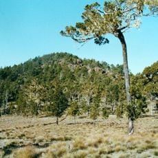
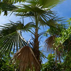
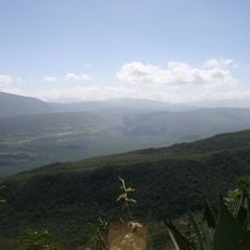
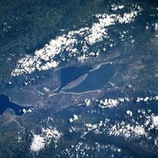
Barreras is a district in Azua province located on a highland plateau at approximately 900 meters elevation. The landscape is defined by the Sierra Martin Garcia mountain range, with rolling terrain that includes farmland and scattered rural settlements.

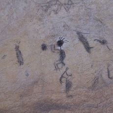
Archaeological evidence shows that Barreroid and Mordanoid indigenous groups inhabited this area between 2800-2600 BCE. This makes the region one of the oldest known human settlements on the island of Hispaniola.

Local fishermen maintain their traditional practices through the La Caobita Fishermen's Association, contributing to the preservation of maritime heritage.

The area is accessible via local roads that pass through farmland and rural communities. Visitors should expect basic country conditions and consider hiring local guides to locate archaeological sites and reach key places in the district.

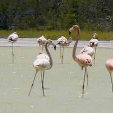
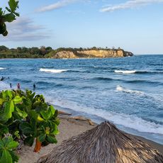
Coastal zones contain natural breakwater formations surrounded by thick mangrove forests. At places like El Uvero and La Caobita, these structures along the beaches create a distinctive ecological environment rich in wildlife.

The community of curious travelers

AroundUs brings together thousands of curated places, local tips, and hidden gems, enriched daily by 60,000 contributors worldwide.

Start exploring
Location
Elevation above the sea
900 m
GPS coordinates
18.32430,-70.90290
Latest update
December 14, 2025 13:08
Around this place
Pico Duarte
Dominican Republic

Pico Duarte

78.4 km
Puerta del Conde
Dominican Republic

Puerta del Conde

108.1 km
Teatro Nacional Eduardo Brito
Dominican Republic

Teatro Nacional Eduardo Brito

106.1 km
National Palace
Dominican Republic

National Palace

107.5 km
Estadio Olímpico Félix Sánchez
Dominican Republic

Estadio Olímpico Félix Sánchez

105.4 km
Flag Square of Santo Domingo
Dominican Republic

Flag Square of Santo Domingo

99 km
Valle Nuevo National Park
Dominican Republic

Valle Nuevo National Park

53.1 km
Jaragua National Park
Dominican Republic

Jaragua National Park

86.8 km
Dr. Rafael Ma. Moscoso National Botanical Garden
Dominican Republic

Dr. Rafael Ma. Moscoso National Botanical Garden

101.4 km
Museo del Hombre Dominicano
Dominican Republic

Museo del Hombre Dominicano

106.4 km
Museum Memorial de la Resistencia Dominicana
Dominican Republic

Museum Memorial de la Resistencia Dominicana

108.4 km
Dominican Republic

Pantoja

97.8 km
Sierra de Bahoruco National Park
Dominican Republic

Sierra de Bahoruco National Park

65.7 km
Altar of the Homeland
Dominican Republic

Altar of the Homeland

108 km
Pomier Caves
Dominican Republic

Pomier Caves

82.7 km
Malecon Center
Dominican Republic

Malecon Center

105.9 km
Winston Churchill Avenue, Dominican Republic
Dominican Republic

Winston Churchill Avenue, Dominican Republic

102.9 km
Nationalpark Lago Enriqillo e Isla Cabritos
Dominican Republic

Nationalpark Lago Enriqillo e Isla Cabritos

82.8 km
Museo Nacional de Historia Natural
Dominican Republic

Museo Nacional de Historia Natural

106.3 km
Santo Domingo Dominican Republic Temple
Dominican Republic

Santo Domingo Dominican Republic Temple

105.3 km
Dominican Republic

Al-Noor Mosque

106.9 km
Parque Piedras Vivas
Dominican Republic

Parque Piedras Vivas

84.4 km
Dominican Republic

Museo Bellapart

104.7 km
Centro Israelita de República Dominicana
Dominican Republic

Centro Israelita de República Dominicana

103.8 km
Playa Najayo
Dominican Republic

Playa Najayo

83.9 km
Casa Caoba (Trujillo)
Dominican Republic

Casa Caoba (Trujillo)

82.4 km
Salto de Jimenoa Uno
Dominican Republic

Salto de Jimenoa Uno

91.6 km
Edificio Saviñón
Dominican Republic

Edificio Saviñón

108.5 km
Show the full map
Reviews
Share your experience

No review yet

Discussions
Start a discussion...

No discussion yet

« Barreras - District in Azua, Dominican Republic » is provided by Around Us (aroundus.com). Images and texts are derived from Wikimedia project under a Creative Commons license. You are allowed to copy, distribute, and modify copies of this page, under the conditions set by the license, as long as this note is clearly visible.

Discover hidden gems everywhere you go!

From secret cafés to breathtaking viewpoints, skip the crowded tourist spots and find places that match your style. Our app makes it easy with voice search, smart filtering, route optimization, and insider tips from travelers worldwide. Download now for the complete mobile experience.

Around Us App Screenshot

A unique approach to discovering new places

Le Figaro

All the places worth exploring

France Info

A tailor-made excursion in just a few clicks

20 Minutes

Around Us
Travel Guide & Maps
Download

Send to your phone

QR Code
1

Open the camera app on your mobile.

2

Point at the QR code with your camera. A notification will appear.

3

Tap the notification to open the link.