Enable Location

We need your location to show you interesting places around you

Discover nearby places

Find interesting locations and hidden gems around you

Precise directions

Get accurate directions and distances to places

Your location is never shared with other users. It's only used when you tap the location button.

Bunnell Water Tower

Log in to your account

Start exploring — it's free

Trusted by 62,514 travelers worldwide

Continue with Google
Continue with Apple
or

We will send you a code to connect

By continuing, you accept our Terms and Conditions and our Privacy Policy

Check your inbox

We've sent a pincode in your inbox. Please enter the code below.

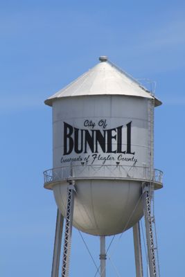
Bunnell Water Tower, Water tower in Bunnell, US

Bunnell Water Tower is a steel structure standing 110 feet tall with a conical top and hemispherical tank bottom supported by four steel columns. The tower holds a capacity of 75,000 gallons and maintains its condition through yearly inspections and complete repainting every five years.

The tower was built in 1926 by the Chicago Bridge & Iron Company and began operating in 1927, becoming a cornerstone of Bunnell's first modern water system. This construction marked a turning point for municipal infrastructure development in the region.

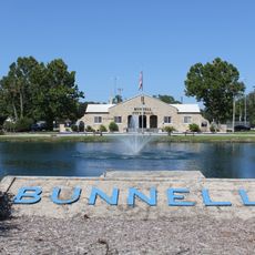
The tower displays painted text identifying Bunnell as the Crossroads of Flagler County, serving as a visual marker of the community's local identity and presence on the regional landscape.

The tower is accessible from the surrounding area and offers visitors an opportunity to see an well-maintained example of early water infrastructure. Best time to visit for photography is in early morning when light is favorable and the area is quiet.

During power outages, the tower functions as an emergency water supply backup when modern storage tanks cannot maintain adequate pressure. This demonstrates how a structure built over a century ago still serves a practical purpose in the community's daily water operations.

The community of curious travelers

AroundUs brings together thousands of curated places, local tips, and hidden gems, enriched daily by 60,000 contributors worldwide.

Start exploring
Location
Inception
1926
Address
100 Utility Street
GPS coordinates
29.46669,-81.25707
Latest update
December 14, 2025 17:03
Around this place
Fort Matanzas National Monument
United States of America

Fort Matanzas National Monument

27.7 km
Marineland of Florida
United States of America

Marineland of Florida

22.9 km
Bulow Plantation Ruins Historic State Park
United States of America

Bulow Plantation Ruins Historic State Park

11.7 km
Washington Oaks State Gardens
United States of America

Washington Oaks State Gardens

19.4 km
Granada Bridge
United States of America

Granada Bridge

28.2 km
Matanzas State Forest
United States of America

Matanzas State Forest

28.1 km
Mala Compra Plantation Archeological Site
United States of America

Mala Compra Plantation Archeological Site

17.4 km
Tomoka State Park
United States of America

Tomoka State Park

22 km
Nocoroco
United States of America

Nocoroco

20.8 km
Cherokee Grove
United States of America

Cherokee Grove

21.4 km
Holden House
United States of America

Holden House

0 m
Dix House
United States of America

Dix House

27.6 km
St. Mary Catholic Church
United States of America

St. Mary Catholic Church

24.8 km
Rowallan
United States of America

Rowallan

27.9 km
The Hammocks
United States of America

The Hammocks

27.4 km
Florida Agricultural Museum
United States of America

Florida Agricultural Museum

19.8 km
Crescent City Historic District
United States of America

Crescent City Historic District

24.9 km
Bunnell Coquina City Hall
United States of America

Bunnell Coquina City Hall

0 m
Old Flagler County Courthouse
United States of America

Old Flagler County Courthouse

35 m
Knox Memorial Bridge
United States of America

Knox Memorial Bridge

16.5 km
Fort Matanzas National Monument Headquarters and Visitor Center
United States of America

Fort Matanzas National Monument Headquarters and Visitor Center

27.7 km
Vocational Agriculture Building
United States of America

Vocational Agriculture Building

627 m
Old Bunnell State Bank Building
United States of America

Old Bunnell State Bank Building

281 m
Hubbard House
United States of America

Hubbard House

24.4 km
Flagler Beach Historical Museum
United States of America

Flagler Beach Historical Museum

12.6 km
Fort Fulton
United States of America

Fort Fulton

23.1 km
Talahloka
United States of America

Talahloka

28.2 km
Flagler Beach Historical Museum
United States of America

Flagler Beach Historical Museum

12.6 km
Show the full map
« Bunnell Water Tower - Water tower in Bunnell, US » is provided by Around Us (aroundus.com). Images and texts are derived from Wikimedia project under a Creative Commons license. You are allowed to copy, distribute, and modify copies of this page, under the conditions set by the license, as long as this note is clearly visible.

Discover hidden gems everywhere you go!

From secret cafés to breathtaking viewpoints, skip the crowded tourist spots and find places that match your style. Our app makes it easy with voice search, smart filtering, route optimization, and insider tips from travelers worldwide. Download now for the complete mobile experience.

Around Us App Screenshot

A unique approach to discovering new places

Le Figaro

All the places worth exploring

France Info

A tailor-made excursion in just a few clicks

20 Minutes

Around Us
Travel Guide & Maps
Download

Send to your phone

QR Code
1

Open the camera app on your mobile.

2

Point at the QR code with your camera. A notification will appear.

3

Tap the notification to open the link.