Interstate 26

Log in to your account

AroundUs is a community-driven map of interesting places, built by curious explorers like you. It grows with every review, story, and photo you share.
Connect to save your favorite spots, contribute locations, and create personalized routes.
By continuing, you accept our Terms and Conditions and our Privacy Policy
Add to collection
Map
Suggest a change
Share

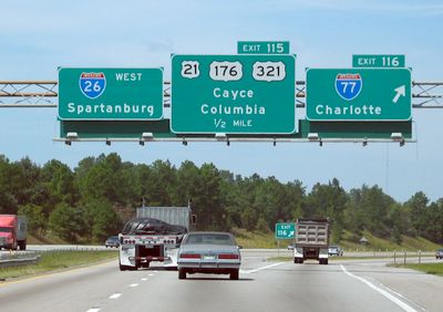
Interstate 26, Interstate highway through Appalachian Mountains, Tennessee and North Carolina, United States

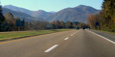
Interstate 26 is a four-lane divided highway that stretches through the Appalachian Mountains, connecting Kingsport in Tennessee to Asheville in North Carolina. The route passes through mountainous terrain with multiple runaway truck ramps and reaches its highest elevation at Sam's Gap.

The highway was built through Appalachian terrain to connect towns shaped by mining and forestry industries. The route underwent several modifications, including a reorganization of exit numbering standards.

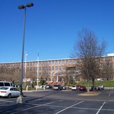
The state welcome center displays regional mountain life through architecture that resembles traditional farmstead buildings.

Driving through mountainous terrain requires attention, especially for trucks dealing with steep grades and descents. Vehicles should be checked before traveling and drivers should take regular breaks.

Near Wolf Laurel the highway provides direct access to a major hiking trail through an underpass system with designated parking for walkers. This setup allows pedestrians to reach the popular route safely.

Location: Tennessee

Location: North Carolina

Location: South Carolina

GPS coordinates: 33.92057,-81.06691

Latest update: December 6, 2025 22:04

Around this place
Show the full map
Best Friend of Charleston
United States of America

Best Friend of Charleston

8.9 km
South Carolina State House
United States of America

South Carolina State House

9.4 km
Williams-Brice Stadium
United States of America

Williams-Brice Stadium

7.3 km
South Carolina State Museum
United States of America

South Carolina State Museum

8.9 km
Capitol Center
United States of America

Capitol Center

9.4 km
Old Campus District, University of South Carolina
United States of America

Old Campus District, University of South Carolina

9.3 km
Gervais Street Bridge
United States of America

Gervais Street Bridge

8.4 km
McCord House
United States of America

McCord House

9.5 km
Guignard Brick Works
United States of America

Guignard Brick Works

7.6 km
Town Theatre
United States of America

Town Theatre

9.5 km
New Brookland Tavern
United States of America

New Brookland Tavern

8.2 km
Curtiss-Wright Hangar
United States of America

Curtiss-Wright Hangar

8.6 km
Still Hopes
United States of America

Still Hopes

7.3 km
Granby Mill Village Historic District
United States of America

Granby Mill Village Historic District

7.4 km
New Brookland Historic District
United States of America

New Brookland Historic District

8.1 km
World War Memorial Building
United States of America

World War Memorial Building

9.3 km
Olympia Armory
United States of America

Olympia Armory

7.2 km
Lyles-Gudmundson House
United States of America

Lyles-Gudmundson House

9.3 km
John C. Calhoun State Office Building
United States of America

John C. Calhoun State Office Building

9.4 km
Main and Gervais
United States of America

Main and Gervais

9.5 km
Building at 303 Saluda Avenue
United States of America

Building at 303 Saluda Avenue

9.3 km
Gunter-Summers House
United States of America

Gunter-Summers House

7.7 km
William J. Cayce House
United States of America

William J. Cayce House

6.2 km
Heslep House
United States of America

Heslep House

9.2 km
Pacific Community Association Building
United States of America

Pacific Community Association Building

7.8 km
South Carolina Confederate Relic Room and Military Museum
United States of America

South Carolina Confederate Relic Room and Military Museum

8.9 km
Palmetto Regiment Mexican War Monument (Columbia)
United States of America

Palmetto Regiment Mexican War Monument (Columbia)

9.3 km
South Caroliniana Library
United States of America

South Caroliniana Library

9.3 km
Show the full map

Reviews

Visited this place? Tap the stars to rate it and share your experience / photos with the community! Try now! You can cancel it anytime.

« Interstate 26 - Interstate highway through Appalachian Mountains, Tennessee and North Carolina, United States » is provided by Around Us (aroundus.com). Images and texts are derived from Wikimedia project under a Creative Commons license. You are allowed to copy, distribute, and modify copies of this page, under the conditions set by the license, as long as this note is clearly visible.

Discover hidden gems everywhere you go!

From secret cafés to breathtaking viewpoints, skip the crowded tourist spots and find places that match your style. Our app makes it easy with voice search, smart filtering, route optimization, and insider tips from travelers worldwide. Download now for the complete mobile experience.

Around Us App Screenshot

A unique approach to discovering new places

Le Figaro

All the places worth exploring

France Info

A tailor-made excursion in just a few clicks

20 Minutes