Chest opened
+${chestReward.xp} XP
Explorer
NOUVEAU ×${chestReward.collectible.quantity}
tapez pour fermer

See the monuments around you in AR Open chests in the app

Around Us is built for your phone — point your camera at the streets and discover the monuments and places around you in augmented reality. Around Us is built for your phone — chests unlock when you walk, explore and capture nearby places.

Enable Location

We need your location to show you interesting places around you

Discover nearby places

Find interesting locations and hidden gems around you

Precise directions

Get accurate directions and distances to places

Your location is never shared with other users. It's only used when you tap the location button.

Log in to your account

Start exploring — it's free

Trusted by 87,264 travelers worldwide

Continue with Google
Continue with Apple
or

We will send you a code to connect

By continuing, you accept our Terms and Conditions and our Privacy Policy

Check your inbox

We've sent a pincode in your inbox. Please enter the code below.

North Inlet-Winyah Bay National Estuarine Research Reserve
Discussion Reviews Photo
2.2k Popularity

North Inlet-Winyah Bay National Estuarine Research Reserve, Coastal research reserve in Georgetown County, South Carolina.

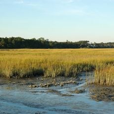
The North Inlet-Winyah Bay Reserve is a coastal area in eastern South Carolina containing salt marshes, oyster beds, beaches, and wooded sections that create varied habitats. The landscape spreads across tidal zones where freshwater rivers meet ocean water, forming a complex network of channels and shallow areas.

The reserve gained its designation in 1992 as a protected research area managed by the University of South Carolina to monitor coastal ecosystems. This recognition came as part of a national effort to study and protect vulnerable marine environments along the American coast.

The reserve serves as a learning hub where visitors discover how salt marshes, oyster reefs, and coastal forests support local wildlife. Walking through its natural areas, you see how people have worked to protect these ecosystems for both recreation and research.

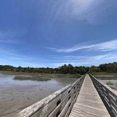
Access is available through marked trails and observation points where you can check real-time water conditions like temperature and salinity. The best time to explore is at low tide, when more land becomes visible and walking is easier across the exposed areas.

The area contains two distinctly different water systems: North Inlet with clear ocean water and Winyah Bay fed by four major rivers. This combination makes it one of the most important study sites on the East Coast for understanding how river and ocean waters interact.

The community of curious travelers

AroundUs brings together thousands of curated places, local tips, and hidden gems, enriched daily by 60,000 contributors worldwide.
Start exploring
Location
GPS coordinates
33.31600,-79.18100
Latest update
September 12, 2026 01:23
Around this place
Brookgreen Gardens
United States of America

Brookgreen Gardens

15 mi
United States of America

Atalaya Castle

14.4 mi
Huntington Beach State Park
United States of America

Huntington Beach State Park

15.3 mi
Huntington Beach State Park

Huntington Beach State Park

15.4 mi
Hopsewee
United States of America

Hopsewee

13.9 mi
Brookgreen Gardens
United States of America

Brookgreen Gardens

15.9 mi
Arcadia Plantation
United States of America

Arcadia Plantation

5.3 mi
Black River Plantation House
United States of America

Black River Plantation House

15.1 mi
Beneventum Plantation House
United States of America

Beneventum Plantation House

10.1 mi
Annandale Plantation
United States of America

Annandale Plantation

9.8 mi
Atalaya and Brookgreen Gardens
United States of America

Atalaya and Brookgreen Gardens

14.8 mi
Battery White
United States of America

Battery White

6.6 mi
All Saints' Episcopal Church, Waccamaw
United States of America

All Saints' Episcopal Church, Waccamaw

10.7 mi
Georgetown Light
United States of America

Georgetown Light

6.5 mi
Pee Dee River Rice Planters Historic District
United States of America

Pee Dee River Rice Planters Historic District

11.8 mi
Temple Beth Elohim
United States of America

Temple Beth Elohim

6.8 mi
Pawleys Island Historic District
United States of America

Pawleys Island Historic District

8 mi
Prince Frederick's Chapel Ruins
United States of America

Prince Frederick's Chapel Ruins

13.1 mi
Wicklow Hall Plantation
United States of America

Wicklow Hall Plantation

10.5 mi
Georgetown Historic District
United States of America

Georgetown Historic District

6.7 mi
Cedar Grove Plantation Chapel
United States of America

Cedar Grove Plantation Chapel

10.7 mi
Joseph H. Rainey House
United States of America

Joseph H. Rainey House

7 mi
Winyah Indigo School
United States of America

Winyah Indigo School

7.2 mi
Summer Chapel, Prince Frederick's Episcopal Church
United States of America

Summer Chapel, Prince Frederick's Episcopal Church

16.6 mi
Kaminski House Museum
United States of America

Kaminski House Museum

7.1 mi
St. Mary's Church
United States of America

St. Mary's Church

6.9 mi
Winyah Indigo Society Hall
United States of America

Winyah Indigo Society Hall

6.6 mi
Georgetown County Courthouse
United States of America

Georgetown County Courthouse

6.8 mi
Show the full map
Reviews
Share your experience

No review yet

Discussions
Start a discussion...

No discussion yet

« North Inlet-Winyah Bay National Estuarine Research Reserve - Coastal research reserve in Georgetown County, South Carolina » is provided by Around Us (aroundus.com). Images and texts are derived from Wikimedia project under a Creative Commons license. You are allowed to copy, distribute, and modify copies of this page, under the conditions set by the license, as long as this note is clearly visible.

Discover hidden gems everywhere you go!

From secret cafés to breathtaking viewpoints, skip the crowded tourist spots and find places that match your style. Our app makes it easy with voice search, smart filtering, route optimization, and insider tips from travelers worldwide. Download now for the complete mobile experience.
Around Us App Screenshot

A unique approach to discovering new places

Le Figaro

All the places worth exploring

France Info

A tailor-made excursion in just a few clicks

20 Minutes

Around Us
Travel Guide & Maps
Download

Send to your phone

QR Code
1

Open the camera app on your mobile.

2

Point at the QR code with your camera. A notification will appear.

3

Tap the notification to open the link.