Chest opened
+${chestReward.xp} XP
Explorer
NOUVEAU ×${chestReward.collectible.quantity}
tapez pour fermer
Chest locked

Open chests in the app

Around Us is built for your phone — chests unlock when you walk, explore and capture nearby places.

Enable Location

We need your location to show you interesting places around you

Discover nearby places

Find interesting locations and hidden gems around you

Precise directions

Get accurate directions and distances to places

Your location is never shared with other users. It's only used when you tap the location button.

Frying Pan Shoals Light

Log in to your account

Start exploring — it's free

Trusted by 72,959 travelers worldwide

Continue with Google
Continue with Apple
or

We will send you a code to connect

By continuing, you accept our Terms and Conditions and our Privacy Policy

Check your inbox

We've sent a pincode in your inbox. Please enter the code below.

Frying Pan Shoals Light
Discussion Reviews 1 Photos
55.8k Popularity

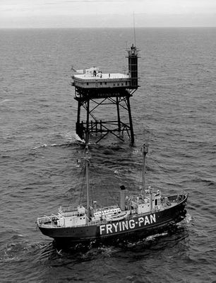
Frying Pan Shoals Light, Maritime lighthouse in Brunswick County, North Carolina, United States.

Frying Pan Shoals Light is a steel framework lighthouse 32 miles (51 km) off the coast of North Carolina in the Atlantic Ocean. The construction stands on four massive steel legs above the water and contains several levels with living quarters and a lantern at the top.

The tower was built in 1966 as a replacement for a lightship that had served these dangerous waters since 1854. After 37 years of operation, the beacon was decommissioned in 2003 and the facility was later taken over by a nonprofit organization.

The name comes from the shallow underwater sandbars shaped like a frying pan that threatened ships for centuries. Science teams work here regularly and use the tower as a floating research base for ocean and weather studies.

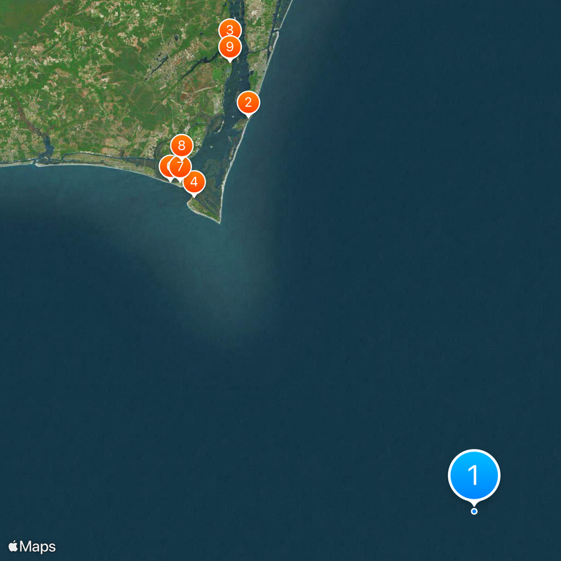
Travel is only possible with private boats or helicopters as there are no regular ferry connections. Visits are only possible by prior arrangement and require a certain level of fitness because of the steep ladders between levels.

After Hurricane Florence in 2018, a torn flag remained at the top for days and became a symbol of resilience. The Coast Guard named the flag Kevin after photos of it went viral on social media.

The community of curious travelers

AroundUs brings together thousands of curated places, local tips, and hidden gems, enriched daily by 60,000 contributors worldwide.

Start exploring
Location
GPS coordinates
33.48333,-77.58333
Latest update
December 14, 2025 17:17
Around this place
Fort Fisher
United States of America

Fort Fisher

62.6 km
Orton Plantation
United States of America

Orton Plantation

72.5 km
Bald Head Light
United States of America

Bald Head Light

58.1 km
Brunswick Town
United States of America

Brunswick Town

70.5 km
Oak Island Light
United States of America

Oak Island Light

61.9 km
North Carolina Baptist Assembly
United States of America

North Carolina Baptist Assembly

60.9 km
Fort Johnston
United States of America

Fort Johnston

62.9 km
Fort Anderson
United States of America

Fort Anderson

70.5 km
Carolina Beach State Park
United States of America

Carolina Beach State Park

70 km
Fort Caswell Historic District
United States of America

Fort Caswell Historic District

61.3 km
Fort Fisher State Recreation Area
United States of America

Fort Fisher State Recreation Area

61.4 km
St. Philip's Church, Brunswick Town
United States of America

St. Philip's Church, Brunswick Town

70.6 km
Cape Fear Light
United States of America

Cape Fear Light

61.8 km
Price Creek Light
United States of America

Price Creek Light

62.9 km
G. V. Barbee Bridge
United States of America

G. V. Barbee Bridge

66.6 km
Corncake Inlet, North Carolina
United States of America

Corncake Inlet, North Carolina

58.9 km
Brunswick Town Historic District
United States of America

Brunswick Town Historic District

70.5 km
Swain's Cut Bridge
United States of America

Swain's Cut Bridge

72.7 km
Brunswick County Courthouse
United States of America

Brunswick County Courthouse

63 km
Joy Lee Apartment Building and Annex
United States of America

Joy Lee Apartment Building and Annex

67.9 km
Hatch Auditorium
United States of America

Hatch Auditorium

60.8 km
Southport Historic District
United States of America

Southport Historic District

63.2 km
Bald Head Creek Boathouse
United States of America

Bald Head Creek Boathouse

56.3 km
Brunswick Town/Fort Anderson State Historic Site
United States of America

Brunswick Town/Fort Anderson State Historic Site

70.5 km
Old Brunswick County Jail
United States of America

Old Brunswick County Jail

63 km
Fort Fisher State Historic Site
United States of America

Fort Fisher State Historic Site

62.4 km
Caswell Beach
United States of America

Caswell Beach

63.1 km
Long Beach
United States of America

Long Beach

71.4 km
Show the full map
Reviews
Share your experience

No review yet

Discussions
Start a discussion...

No discussion yet

« Frying Pan Shoals Light - Maritime lighthouse in Brunswick County, North Carolina, United States » is provided by Around Us (aroundus.com). Images and texts are derived from Wikimedia project under a Creative Commons license. You are allowed to copy, distribute, and modify copies of this page, under the conditions set by the license, as long as this note is clearly visible.

Discover hidden gems everywhere you go!

From secret cafés to breathtaking viewpoints, skip the crowded tourist spots and find places that match your style. Our app makes it easy with voice search, smart filtering, route optimization, and insider tips from travelers worldwide. Download now for the complete mobile experience.

Around Us App Screenshot

A unique approach to discovering new places

Le Figaro

All the places worth exploring

France Info

A tailor-made excursion in just a few clicks

20 Minutes

Around Us
Travel Guide & Maps
Download

Send to your phone

QR Code
1

Open the camera app on your mobile.

2

Point at the QR code with your camera. A notification will appear.

3

Tap the notification to open the link.