Enable Location

We need your location to show you interesting places around you

Discover nearby places

Find interesting locations and hidden gems around you

Precise directions

Get accurate directions and distances to places

Your location is never shared with other users. It's only used when you tap the location button.

Palo Corona Regional Park

Log in to your account

Start exploring — it's free

Trusted by 62,022 travelers worldwide

Continue with Google
Continue with Apple
or

We will send you a code to connect

By continuing, you accept our Terms and Conditions and our Privacy Policy

Check your inbox

We've sent a pincode in your inbox. Please enter the code below.

Palo Corona Regional Park

Palo Corona Regional Park, Regional park in Carmel Valley, US

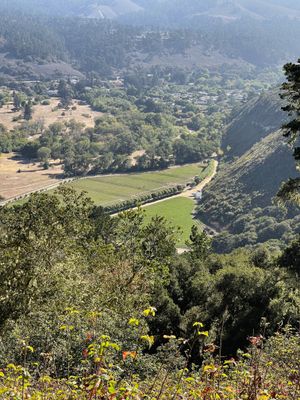
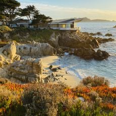
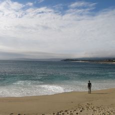
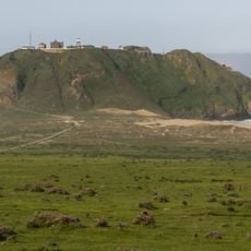
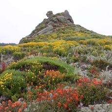
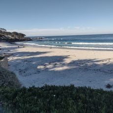
Palo Corona Regional Park is a large protected area that stretches from the coast to the mountains, containing diverse habitats and landscapes. The property features forested valleys, grassy slopes, and ridges that rise steeply from the valley floor.

The property was purchased in 2002 by conservation organizations to prevent building development and protect natural ecosystems. This action saved large areas of forest and grassland from development projects.

The park serves the local community as a place to connect with nature through walking trails that pass through forests and open hillsides. Visitors come to experience the landscape's varied character without encountering commercial development.

Visitors can access the park through several entry points, though some require advance permission before arrival. It helps to check access options in advance and wear sturdy shoes for uneven terrain.

The protected area contains water sources that feed into a wide network of streams and rivers across the region. Many people do not realize how much of the area's water supply originates from these hidden springs underground.

The community of curious travelers

AroundUs brings together thousands of curated places, local tips, and hidden gems, enriched daily by 60,000 contributors worldwide.

Start exploring
GPS coordinates
36.42167,-121.90722
Latest update
December 14, 2025 14:24
Around this place
Bixby Creek Bridge
United States of America

Bixby Creek Bridge

5.6 km
Mission San Carlos Borromeo de Carmelo
United States of America

Mission San Carlos Borromeo de Carmelo

13.5 km
Mrs. Clinton Walker House
United States of America

Mrs. Clinton Walker House

13.8 km
Point Sur Lighthouse
United States of America

Point Sur Lighthouse

13 km
Garrapata State Park
United States of America

Garrapata State Park

5.3 km
Tor House and Hawk Tower
United States of America

Tor House and Hawk Tower

13.6 km
Butterfly House
United States of America

Butterfly House

13.5 km
Carmel River State Beach
United States of America

Carmel River State Beach

12.4 km
Forest Theater
United States of America

Forest Theater

14.6 km
Point Sur State Historic Park
United States of America

Point Sur State Historic Park

12.8 km
Driftwood Cottage
United States of America

Driftwood Cottage

13.4 km
Rocky Creek Bridge
United States of America

Rocky Creek Bridge

4.7 km
United States of America

Sunset Center

14.5 km
Golden Bough Playhouse
United States of America

Golden Bough Playhouse

14.6 km
United States of America

Palo Corona Ranch

12.4 km
Geological history of Point Lobos
United States of America

Geological history of Point Lobos

11.1 km
Enchanted Oaks Building
United States of America

Enchanted Oaks Building

14.8 km
Tuck Box
United States of America

Tuck Box

14.8 km
Outlands in the Eighty Acres
United States of America

Outlands in the Eighty Acres

14.1 km
United States of America

Carmel City Hall

14.9 km
Whalers Cabin
United States of America

Whalers Cabin

11.1 km
Seaburst House
United States of America

Seaburst House

13.8 km
Point Lobos State Reserve
United States of America

Point Lobos State Reserve

11.1 km
United States of America

T.A. Oakes Building

14.8 km
Theatre of the Golden Bough
United States of America

Theatre of the Golden Bough

14.6 km
Percy Parkes Building
United States of America

Percy Parkes Building

14.8 km
De Yoe Building
United States of America

De Yoe Building

14.8 km
Carmel Beach
United States of America

Carmel Beach

14.5 km
Show the full map
« Palo Corona Regional Park - Regional park in Carmel Valley, US » is provided by Around Us (aroundus.com). Images and texts are derived from Wikimedia project under a Creative Commons license. You are allowed to copy, distribute, and modify copies of this page, under the conditions set by the license, as long as this note is clearly visible.

Discover hidden gems everywhere you go!

From secret cafés to breathtaking viewpoints, skip the crowded tourist spots and find places that match your style. Our app makes it easy with voice search, smart filtering, route optimization, and insider tips from travelers worldwide. Download now for the complete mobile experience.

Around Us App Screenshot

A unique approach to discovering new places

Le Figaro

All the places worth exploring

France Info

A tailor-made excursion in just a few clicks

20 Minutes

Around Us
Travel Guide & Maps
Download

Send to your phone

QR Code
1

Open the camera app on your mobile.

2

Point at the QR code with your camera. A notification will appear.

3

Tap the notification to open the link.