Enable Location

We need your location to show you interesting places around you

Discover nearby places

Find interesting locations and hidden gems around you

Precise directions

Get accurate directions and distances to places

Your location is never shared with other users. It's only used when you tap the location button.

Rocky Creek Bridge

Log in to your account

Start exploring — it's free

Trusted by 61,368 travelers worldwide

Continue with Google
Continue with Apple
or

We will send you a code to connect

By continuing, you accept our Terms and Conditions and our Privacy Policy

Check your inbox

We've sent a pincode in your inbox. Please enter the code below.

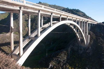
Rocky Creek Bridge, Deck arch bridge on California State Route 1, United States

Description

Rocky Creek Bridge is a reinforced concrete arch spanning the creek below with a parabolic vault shape and cantilevered walkways on both sides. The structure uses thin arches and heavy piers to bridge the deep ravine.

History

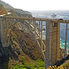
Construction finished in 1932 as part of the Carmel-San Simeon Highway project, which connected settlements along Big Sur. It was built during a period when advanced concrete techniques allowed engineers to create daring structures across difficult terrain.

Culture

The bridge is one of seven distinctive arch structures in Big Sur, reflecting how engineers of the era solved the problem of crossing deep coastal canyons. Local people and visitors recognize it as a symbol of the region's identity and its engineering heritage.

Practical

A designated parking area northwest of the structure provides viewing access and space to take photographs. Visitors should expect variable weather conditions, as coastal fog often limits visibility.

Did you know?

The piers are built unusually thick while the arches are kept deliberately thin, a bold design choice that gives the structure visual interest. This particular construction approach earned it recognition on the National Register of Historic Places and sets it apart from more conventional bridge designs.

Location
Inception
1932
Made from material
reinforced concrete
GPS coordinates
36.37940,-121.90200
Latest update
December 10, 2025 16:27

AroundUs brings together thousands of curated places, local tips, and hidden gems, enriched daily by 60,000 contributors worldwide. Discover all places nearby (California).

Around this place
Bixby Creek Bridge
United States of America

Bixby Creek Bridge

891 m
Mission San Carlos Borromeo de Carmelo
United States of America

Mission San Carlos Borromeo de Carmelo

18.3 km
Pfeiffer Big Sur State Park
United States of America

Pfeiffer Big Sur State Park

18.2 km
Mrs. Clinton Walker House
United States of America

Mrs. Clinton Walker House

18.5 km
Point Sur Lighthouse
United States of America

Point Sur Lighthouse

8.3 km
Garrapata State Park
United States of America

Garrapata State Park

10 km
Andrew Molera State Park
United States of America

Andrew Molera State Park

12.4 km
Tor House and Hawk Tower
United States of America

Tor House and Hawk Tower

18.3 km
Butterfly House
United States of America

Butterfly House

18.2 km
Carmel River State Beach
United States of America

Carmel River State Beach

17.2 km
Forest Theater
United States of America

Forest Theater

19.3 km
Point Sur State Historic Park
United States of America

Point Sur State Historic Park

8.1 km
Pfeiffer Beach
United States of America

Pfeiffer Beach

17.4 km
Driftwood Cottage
United States of America

Driftwood Cottage

18.1 km
United States of America

Sunset Center

19.2 km
San Clemente Dam
United States of America

San Clemente Dam

18.4 km
Golden Bough Playhouse
United States of America

Golden Bough Playhouse

19.3 km
United States of America

Palo Corona Ranch

17.1 km
Geological history of Point Lobos
United States of America

Geological history of Point Lobos

15.8 km
Enchanted Oaks Building
United States of America

Enchanted Oaks Building

19.5 km
Outlands in the Eighty Acres
United States of America

Outlands in the Eighty Acres

18.9 km
Palo Corona Regional Park
United States of America

Palo Corona Regional Park

4.7 km
Whalers Cabin
United States of America

Whalers Cabin

15.8 km
Seaburst House
United States of America

Seaburst House

18.5 km
Point Lobos State Reserve
United States of America

Point Lobos State Reserve

15.8 km
Theatre of the Golden Bough
United States of America

Theatre of the Golden Bough

19.3 km
Keyhole Arch
United States of America

Keyhole Arch

17.5 km
Carmel Beach
United States of America

Carmel Beach

19.2 km
Show the full map
« Rocky Creek Bridge - Deck arch bridge on California State Route 1, United States » is provided by Around Us (aroundus.com). Images and texts are derived from Wikimedia project under a Creative Commons license. You are allowed to copy, distribute, and modify copies of this page, under the conditions set by the license, as long as this note is clearly visible.

Discover hidden gems everywhere you go!

From secret cafés to breathtaking viewpoints, skip the crowded tourist spots and find places that match your style. Our app makes it easy with voice search, smart filtering, route optimization, and insider tips from travelers worldwide. Download now for the complete mobile experience.

Around Us App Screenshot

A unique approach to discovering new places

Le Figaro

All the places worth exploring

France Info

A tailor-made excursion in just a few clicks

20 Minutes

Around Us
Travel Guide & Maps
Download

Send to your phone

QR Code
1

Open the camera app on your mobile.

2

Point at the QR code with your camera. A notification will appear.

3

Tap the notification to open the link.