Enable Location

We need your location to show you interesting places around you

Discover nearby places

Find interesting locations and hidden gems around you

Precise directions

Get accurate directions and distances to places

Your location is never shared with other users. It's only used when you tap the location button.

Keyhole Arch

Log in to your account

Start exploring — it's free

Trusted by 61,367 travelers worldwide

Continue with Google
Continue with Apple
or

We will send you a code to connect

By continuing, you accept our Terms and Conditions and our Privacy Policy

Check your inbox

We've sent a pincode in your inbox. Please enter the code below.

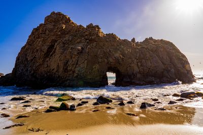
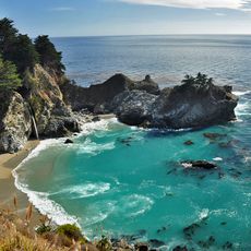
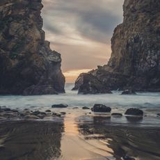
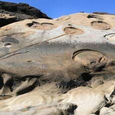
Keyhole Arch, Natural arch at Pfeiffer Beach, Big Sur, US

Description

Keyhole Arch is a sandstone formation on the Big Sur coast with a large opening carved by ocean waves over time. This natural opening creates a distinctive frame toward the Pacific Ocean and rises approximately 70 feet (21 m) from the water.

History

The structure formed over millions of years through continuous erosion of sedimentary rocks by powerful ocean currents and wind. This steady force gradually carved out the distinctive opening visible today.

Culture

Every winter, photographers gather at this location to capture the rare phenomenon of sunlight beaming through the arch during winter solstice.

Practical

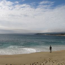
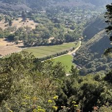
Access the formation via Sycamore Canyon Road from Highway 1 at Pfeiffer Beach. The best views and photography happen from the rocks around the cove, and you should plan to visit during daylight hours.

Did you know?

During December and January, when the setting sun aligns just right, an orange beam shines directly through the opening. This rare display of natural light draws many photographers hoping to capture the moment.

Location
Address
Sycamore Canyon Rd, Big Sur, CA 93920, USA
GPS coordinates
36.23818,-121.81733
Latest update
December 6, 2025 19:05

AroundUs brings together thousands of curated places, local tips, and hidden gems, enriched daily by 60,000 contributors worldwide. Discover all places nearby (Monterey County).

The most beautiful beaches in California

California's beaches stretch from the southern coast to the northern shores, each with its own character. Santa Monica features a historic pier and boardwalk, while Venice Beach buzzes with artists and street performers. Laguna Beach impresses with its cliffs and hidden coves, and Pfeiffer Beach...

Around this place
Big Sur
United States of America

Big Sur

22.5 km
Bixby Creek Bridge
United States of America

Bixby Creek Bridge

16.7 km
Mission San Carlos Borromeo de Carmelo
United States of America

Mission San Carlos Borromeo de Carmelo

35.1 km
McWay Falls
United States of America

McWay Falls

15.8 km
Julia Pfeiffer Burns State Park
United States of America

Julia Pfeiffer Burns State Park

15.4 km
Pfeiffer Big Sur State Park
United States of America

Pfeiffer Big Sur State Park

3.3 km
Tassajara Zen Mountain Center
United States of America

Tassajara Zen Mountain Center

25.1 km
Tassajara Hot Springs
United States of America

Tassajara Hot Springs

24 km
Mrs. Clinton Walker House
United States of America

Mrs. Clinton Walker House

35.5 km
Point Sur Lighthouse
United States of America

Point Sur Lighthouse

10.4 km
Garrapata State Park
United States of America

Garrapata State Park

27 km
Andrew Molera State Park
United States of America

Andrew Molera State Park

5.2 km
Tor House and Hawk Tower
United States of America

Tor House and Hawk Tower

35.3 km
Ventana Wilderness
United States of America

Ventana Wilderness

13.6 km
Butterfly House
United States of America

Butterfly House

35.3 km
Carmel River State Beach
United States of America

Carmel River State Beach

34.2 km
Point Sur State Historic Park
United States of America

Point Sur State Historic Park

10.6 km
Pfeiffer Beach
United States of America

Pfeiffer Beach

51 m
Driftwood Cottage
United States of America

Driftwood Cottage

35.1 km
Rocky Creek Bridge
United States of America

Rocky Creek Bridge

17.5 km
Big Creek Bridge
United States of America

Big Creek Bridge

27 km
Big Creek State Marine Reserve and Big Creek State Marine Conservation Area
United States of America

Big Creek State Marine Reserve and Big Creek State Marine Conservation Area

21 km
San Clemente Dam
United States of America

San Clemente Dam

24.1 km
United States of America

Palo Corona Ranch

33.8 km
Geological history of Point Lobos
United States of America

Geological history of Point Lobos

33 km
Palo Corona Regional Park
United States of America

Palo Corona Regional Park

22 km
Whalers Cabin
United States of America

Whalers Cabin

32.9 km
Point Lobos State Reserve
United States of America

Point Lobos State Reserve

33 km
Show the full map
« Keyhole Arch - Natural arch at Pfeiffer Beach, Big Sur, US » is provided by Around Us (aroundus.com). Images and texts are derived from Wikimedia project under a Creative Commons license. You are allowed to copy, distribute, and modify copies of this page, under the conditions set by the license, as long as this note is clearly visible.

Discover hidden gems everywhere you go!

From secret cafés to breathtaking viewpoints, skip the crowded tourist spots and find places that match your style. Our app makes it easy with voice search, smart filtering, route optimization, and insider tips from travelers worldwide. Download now for the complete mobile experience.

Around Us App Screenshot

A unique approach to discovering new places

Le Figaro

All the places worth exploring

France Info

A tailor-made excursion in just a few clicks

20 Minutes

Around Us
Travel Guide & Maps
Download

Send to your phone

QR Code
1

Open the camera app on your mobile.

2

Point at the QR code with your camera. A notification will appear.

3

Tap the notification to open the link.