Enable Location

We need your location to show you interesting places around you

Discover nearby places

Find interesting locations and hidden gems around you

Precise directions

Get accurate directions and distances to places

Your location is never shared with other users. It's only used when you tap the location button.

Big Creek State Marine Reserve and Big Creek State Marine Conservation Area

Log in to your account

Start exploring — it's free

Trusted by 61,365 travelers worldwide

Continue with Google
Continue with Apple
or

We will send you a code to connect

By continuing, you accept our Terms and Conditions and our Privacy Policy

Check your inbox

We've sent a pincode in your inbox. Please enter the code below.

Big Creek State Marine Reserve and Big Creek State Marine Conservation Area

Big Creek State Marine Reserve and Big Creek State Marine Conservation Area, Marine reserves in Big Sur, United States.

Description

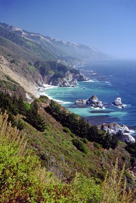
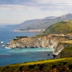
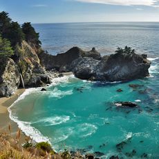
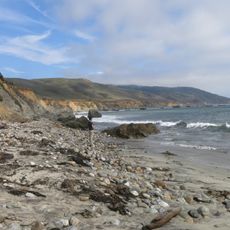
Big Creek State Marine Reserve and Big Creek State Marine Conservation Area are protected zones off California's central coast where steep underwater canyons and dense kelp forests shape the marine habitat. The Reserve prohibits all fishing, while the adjoining Conservation Area allows limited commercial and recreational fishing of specific species.

History

The marine reserve was established in 1994 to protect the coastal ecosystem from overuse, and the adjacent conservation area followed in 2007 to extend protection. These actions were part of California's broader effort to safeguard its marine habitats.

Culture

Local fishing communities maintain their connection to these waters through practices passed down over time, which continue to shape how people in the area relate to the coast. The traditions visible in the region reflect a long relationship between residents and the marine environment.

Practical

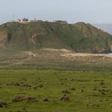
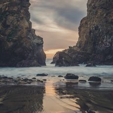
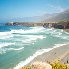
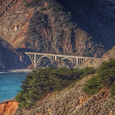
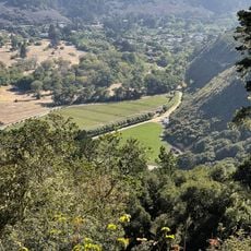
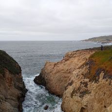
The best visits happen from the shore, where overlooks and coastal trails offer views across the protected area. Visitors should know that direct water access is difficult, but views from above reveal the richness of this marine landscape.

Did you know?

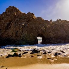
The underwater canyons plunge as deep as mountains are tall, with rock formations that shelter rare fish species not commonly found along this coast. This deep zone makes the area a kind of refuge for species that are scarce elsewhere in the region.

GPS coordinates
36.12222,-121.63333
Latest update
December 12, 2025 09:05

AroundUs brings together thousands of curated places, local tips, and hidden gems, enriched daily by 60,000 contributors worldwide. Discover all places nearby (United States of America).

Around this place
Big Sur
United States of America

Big Sur

1.8 km
Bixby Creek Bridge
United States of America

Bixby Creek Bridge

36.8 km
McWay Falls
United States of America

McWay Falls

5.3 km
Julia Pfeiffer Burns State Park
United States of America

Julia Pfeiffer Burns State Park

6.1 km
Pfeiffer Big Sur State Park
United States of America

Pfeiffer Big Sur State Park

19.3 km
Mission Nuestra Señora de la Soledad
United States of America

Mission Nuestra Señora de la Soledad

40.1 km
Tassajara Zen Mountain Center
United States of America

Tassajara Zen Mountain Center

27.8 km
Tassajara Hot Springs
United States of America

Tassajara Hot Springs

14.5 km
Point Sur Lighthouse
United States of America

Point Sur Lighthouse

31.3 km
Limekiln State Park
United States of America

Limekiln State Park

16.2 km
Garrapata State Park
United States of America

Garrapata State Park

45.9 km
Andrew Molera State Park
United States of America

Andrew Molera State Park

25.4 km
Ventana Wilderness
United States of America

Ventana Wilderness

14.5 km
Junipero Serra Peak
United States of America

Junipero Serra Peak

19.4 km
Point Sur State Historic Park
United States of America

Point Sur State Historic Park

31.5 km
Pfeiffer Beach
United States of America

Pfeiffer Beach

21 km
Rocky Creek Bridge
United States of America

Rocky Creek Bridge

37.4 km
Salmon Creek Falls
United States of America

Salmon Creek Falls

42.2 km
Sand Dollar Beach
United States of America

Sand Dollar Beach

26.6 km
Big Creek Bridge
United States of America

Big Creek Bridge

6.5 km
San Clemente Dam
United States of America

San Clemente Dam

35.6 km
Silver Peak Wilderness
United States of America

Silver Peak Wilderness

44 km
Palo Corona Regional Park
United States of America

Palo Corona Regional Park

41.4 km
1 (Las Cruces - San Francisco)
United States of America

1 (Las Cruces - San Francisco)

23.8 km
Mission Soledad Museum
United States of America

Mission Soledad Museum

40.1 km
Fort Hunter Liggett
United States of America

Fort Hunter Liggett

40.9 km
Keyhole Arch
United States of America

Keyhole Arch

21 km
Manzoni Estate Vineyard
United States of America

Manzoni Estate Vineyard

41.7 km
Show the full map
« Big Creek State Marine Reserve and Big Creek State Marine Conservation Area - Marine reserves in Big Sur, United States » is provided by Around Us (aroundus.com). Images and texts are derived from Wikimedia project under a Creative Commons license. You are allowed to copy, distribute, and modify copies of this page, under the conditions set by the license, as long as this note is clearly visible.

Discover hidden gems everywhere you go!

From secret cafés to breathtaking viewpoints, skip the crowded tourist spots and find places that match your style. Our app makes it easy with voice search, smart filtering, route optimization, and insider tips from travelers worldwide. Download now for the complete mobile experience.

Around Us App Screenshot

A unique approach to discovering new places

Le Figaro

All the places worth exploring

France Info

A tailor-made excursion in just a few clicks

20 Minutes

Around Us
Travel Guide & Maps
Download

Send to your phone

QR Code
1

Open the camera app on your mobile.

2

Point at the QR code with your camera. A notification will appear.

3

Tap the notification to open the link.