Chest opened
+${chestReward.xp} XP
Explorer
NOUVEAU ×${chestReward.collectible.quantity}
tapez pour fermer

See the monuments around you in AR Open chests in the app

Around Us is built for your phone — point your camera at the streets and discover the monuments and places around you in augmented reality. Around Us is built for your phone — chests unlock when you walk, explore and capture nearby places.

Enable Location

We need your location to show you interesting places around you

Discover nearby places

Find interesting locations and hidden gems around you

Precise directions

Get accurate directions and distances to places

Your location is never shared with other users. It's only used when you tap the location button.

Big Creek Bridge

Log in to your account

Start exploring — it's free

Trusted by 85,220 travelers worldwide

Continue with Google
Continue with Apple
or

We will send you a code to connect

By continuing, you accept our Terms and Conditions and our Privacy Policy

Check your inbox

We've sent a pincode in your inbox. Please enter the code below.

Big Creek Bridge
Discussion Reviews 1 Photos
3.4k Popularity

Big Creek Bridge, Road bridge on Highway 101 in Lane County, Oregon, United States

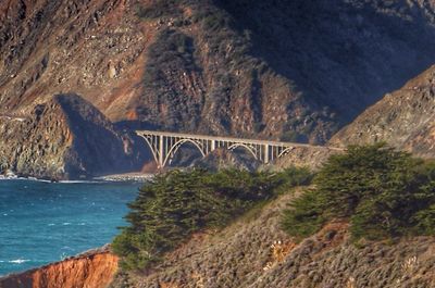
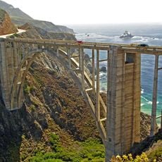
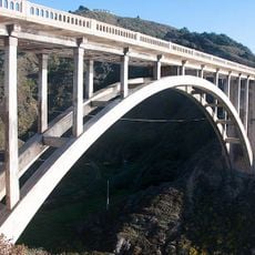
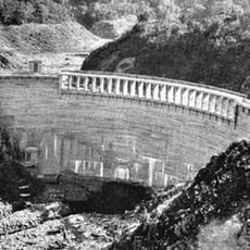
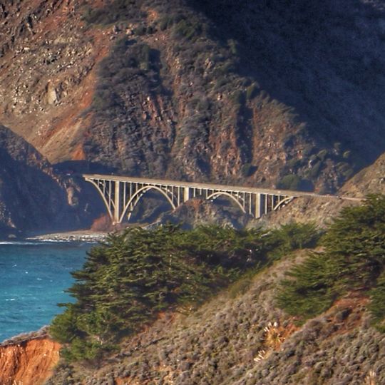
Big Creek Bridge is a road bridge with a single reinforced concrete arch that spans across the stream valley where a creek meets the ocean. The structure carries Highway 101 traffic as it crosses this coastal waterway.

This crossing opened in 1931 following a design approach that later earned recognition on the National Register of Historic Places in 2005. The structure received reinforcement work toward the end of the 20th century to extend its usable life.

The bridge represents an engineering solution that addressed the regional challenges of sandy foundations, high flood levels, and corrosive salt air conditions.

The structure can be easily seen from the main coastal road and serves as a visible landmark of the region. Best views occur while driving along the route or from nearby vantage points along the shoreline.

This crossing shares its distinctive arch design with two other nearby bridges and follows a design pattern patented in the early 1900s. Reusing this proven design allowed builders to solve multiple water crossings efficiently with a tested approach.

The community of curious travelers

AroundUs brings together thousands of curated places, local tips, and hidden gems, enriched daily by 60,000 contributors worldwide.
Start exploring
GPS coordinates
36.07010,-121.60040
Latest update
August 30, 2026 12:55
Around this place
Big Sur
United States of America

Big Sur

18 mi
Bixby Creek Bridge
United States of America

Bixby Creek Bridge

26.8 mi
McWay Falls
United States of America

McWay Falls

7.3 mi
Julia Pfeiffer Burns State Park
United States of America

Julia Pfeiffer Burns State Park

7.8 mi
Pfeiffer Big Sur State Park
United States of America

Pfeiffer Big Sur State Park

15.9 mi
Mission Nuestra Señora de la Soledad
United States of America

Mission Nuestra Señora de la Soledad

26.9 mi
Tassajara Zen Mountain Center
United States of America

Tassajara Zen Mountain Center

20.7 mi
Tassajara Hot Springs
United States of America

Tassajara Hot Springs

11.7 mi
Point Sur Lighthouse
United States of America

Point Sur Lighthouse

23.3 mi
Limekiln State Park
United States of America

Limekiln State Park

6.2 mi
Garrapata State Park
United States of America

Garrapata State Park

32.6 mi
Andrew Molera State Park
United States of America

Andrew Molera State Park

19.7 mi
Ventana Wilderness
United States of America

Ventana Wilderness

13 mi
Junipero Serra Peak
United States of America

Junipero Serra Peak

11.4 mi
Point Sur State Historic Park
United States of America

Point Sur State Historic Park

23.3 mi
Pfeiffer Beach
United States of America

Pfeiffer Beach

16.8 mi
Rocky Creek Bridge
United States of America

Rocky Creek Bridge

27.2 mi
Salmon Creek Falls
United States of America

Salmon Creek Falls

22.2 mi
Sand Dollar Beach
United States of America

Sand Dollar Beach

12.5 mi
Big Creek State Marine Reserve and Big Creek State Marine Conservation Area
United States of America

Big Creek State Marine Reserve and Big Creek State Marine Conservation Area

4 mi
San Clemente Dam
United States of America

San Clemente Dam

26 mi
Silver Peak Wilderness
United States of America

Silver Peak Wilderness

23.5 mi
Palo Corona Regional Park
United States of America

Palo Corona Regional Park

29.7 mi
King City High School Auditorium
United States of America

King City High School Auditorium

27.9 mi
Odd Fellows Hall
United States of America

Odd Fellows Hall

31.5 mi
Mission Soledad Museum
United States of America

Mission Soledad Museum

26.9 mi
Fort Hunter Liggett
United States of America

Fort Hunter Liggett

22.2 mi
Keyhole Arch
United States of America

Keyhole Arch

16.8 mi
Show the full map
Reviews
Share your experience

No review yet

Discussions
Start a discussion...

No discussion yet

« Big Creek Bridge - Road bridge on Highway 101 in Lane County, Oregon, United States » is provided by Around Us (aroundus.com). Images and texts are derived from Wikimedia project under a Creative Commons license. You are allowed to copy, distribute, and modify copies of this page, under the conditions set by the license, as long as this note is clearly visible.

Discover hidden gems everywhere you go!

From secret cafés to breathtaking viewpoints, skip the crowded tourist spots and find places that match your style. Our app makes it easy with voice search, smart filtering, route optimization, and insider tips from travelers worldwide. Download now for the complete mobile experience.

Around Us App Screenshot

A unique approach to discovering new places

Le Figaro

All the places worth exploring

France Info

A tailor-made excursion in just a few clicks

20 Minutes

Around Us
Travel Guide & Maps
Download

Send to your phone

QR Code
1

Open the camera app on your mobile.

2

Point at the QR code with your camera. A notification will appear.

3

Tap the notification to open the link.