Enable Location

We need your location to show you interesting places around you

Discover nearby places

Find interesting locations and hidden gems around you

Precise directions

Get accurate directions and distances to places

Your location is never shared with other users. It's only used when you tap the location button.

Bon Tempe Lake

Log in to your account

Start exploring — it's free

Trusted by 62,495 travelers worldwide

Continue with Google
Continue with Apple
or

We will send you a code to connect

By continuing, you accept our Terms and Conditions and our Privacy Policy

Check your inbox

We've sent a pincode in your inbox. Please enter the code below.

Bon Tempe Lake

Bon Tempe Lake, body of water

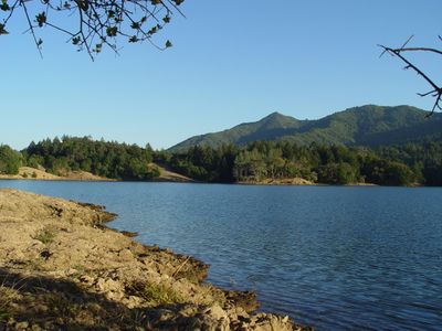
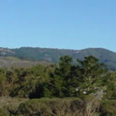
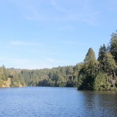
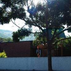
Bon Tempe Lake is a reservoir in Marin County's rolling hills, surrounded by dense forests of redwoods, Douglas firs, and oak trees. The lake covers about 140 acres and is held back by an earthen dam that collects water from Lagunitas Creek.

The lake was constructed in 1948 with the support of the older Alpine Dam, which helped manage water flow in the system. Building the reservoir required moving the Bautunpi family's ranch, which had previously occupied the site.

The name Bon Tempe comes from the Bautunpi family who farmed and raised dairy cattle on this land before the reservoir was built. Today, visitors experience the place as a quiet refuge where the community values both water conservation and access to nature.

The lake sits about 720 feet (220 meters) above sea level and is best visited early in the morning or during off-peak times when fewer people are present. Parking lots can fill quickly on weekends, so arriving early or visiting on weekdays is recommended.

The water contains elevated mercury levels, which is why health agencies advise against eating fish caught here. Despite this caution, fishing remains popular, though the lake has paused fish plantings to help prevent invasive species from spreading.

The community of curious travelers

AroundUs brings together thousands of curated places, local tips, and hidden gems, enriched daily by 60,000 contributors worldwide.

Start exploring
Location
GPS coordinates
37.95583,-122.61111
Latest update
February 7, 2026 11:40
Around this place
Marin County Civic Center
United States of America

Marin County Civic Center

8.6 km
United States of America

Druid Heights

8.5 km
Terrapin Crossroads
United States of America

Terrapin Crossroads

8.4 km
Mount Tamalpais State Park
United States of America

Mount Tamalpais State Park

6.6 km
2 AM Club
United States of America

2 AM Club

9.2 km
Sweetwater Saloon
United States of America

Sweetwater Saloon

7.8 km
Alpine Lake
United States of America

Alpine Lake

2.9 km
Cushing Memorial Amphitheatre
United States of America

Cushing Memorial Amphitheatre

4.8 km
Muir Beach Overlook
United States of America

Muir Beach Overlook

10.6 km
Dixie Schoolhouse
United States of America

Dixie Schoolhouse

10 km
Rodef Sholom
United States of America

Rodef Sholom

9.4 km
Marin Museum of Bicycling
United States of America

Marin Museum of Bicycling

4 km
Lark Theater
United States of America

Lark Theater

7.2 km
Marin Shakespeare Company
United States of America

Marin Shakespeare Company

8.6 km
Larkspur Downtown Historic District
United States of America

Larkspur Downtown Historic District

7.2 km
Edgewood Botanic Garden
United States of America

Edgewood Botanic Garden

7.4 km
San Rafael Improvement Club
United States of America

San Rafael Improvement Club

6.7 km
Audubon Canyon
United States of America

Audubon Canyon

6.9 km
Bradford House
United States of America

Bradford House

6.9 km
Alley
United States of America

Alley

7.9 km
Rafael Film Center
United States of America

Rafael Film Center

7.5 km
Muir Woods Visitor Center
United States of America

Muir Woods Visitor Center

7.8 km
Muir Woods National Monument Historic District
United States of America

Muir Woods National Monument Historic District

7.6 km
Civic Center Library
United States of America

Civic Center Library

8.5 km
Muir Woods National Monument Entrance Gate
United States of America

Muir Woods National Monument Entrance Gate

7.8 km
Bolinas Library
United States of America

Bolinas Library

8.3 km
Alexander-Acacia Bridge
United States of America

Alexander-Acacia Bridge

7.5 km
Muir Woods National Monument Administration-Concession Building
United States of America

Muir Woods National Monument Administration-Concession Building

7.7 km
Show the full map
« Bon Tempe Lake - body of water » is provided by Around Us (aroundus.com). Images and texts are derived from Wikimedia project under a Creative Commons license. You are allowed to copy, distribute, and modify copies of this page, under the conditions set by the license, as long as this note is clearly visible.

Discover hidden gems everywhere you go!

From secret cafés to breathtaking viewpoints, skip the crowded tourist spots and find places that match your style. Our app makes it easy with voice search, smart filtering, route optimization, and insider tips from travelers worldwide. Download now for the complete mobile experience.

Around Us App Screenshot

A unique approach to discovering new places

Le Figaro

All the places worth exploring

France Info

A tailor-made excursion in just a few clicks

20 Minutes

Around Us
Travel Guide & Maps
Download

Send to your phone

QR Code
1

Open the camera app on your mobile.

2

Point at the QR code with your camera. A notification will appear.

3

Tap the notification to open the link.