Enable Location

We need your location to show you interesting places around you

Discover nearby places

Find interesting locations and hidden gems around you

Precise directions

Get accurate directions and distances to places

Your location is never shared with other users. It's only used when you tap the location button.

Alpine Lake

Log in to your account

Start exploring — it's free

Trusted by 62,497 travelers worldwide

Continue with Google
Continue with Apple
or

We will send you a code to connect

By continuing, you accept our Terms and Conditions and our Privacy Policy

Check your inbox

We've sent a pincode in your inbox. Please enter the code below.

Alpine Lake

Alpine Lake, reservoir in Marin County, California

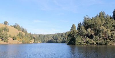
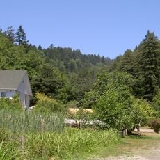
Lake Alpine is a mountain reservoir in California at over 7,200 feet elevation, surrounded by red fir and lodgepole pine trees. The clear water covers about 180 acres and is 2 miles east of Bear Valley, offering swimming, boating, hiking, and fishing.

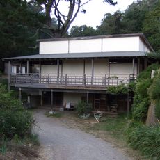
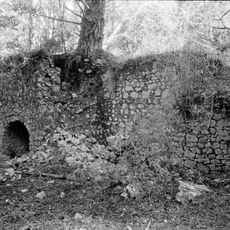
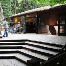
The lake formed in 1892 when a mining company built a dam across Silver Creek to store water for operations. A supply cabin at Dynan's Cove became the first lodge in the late 1920s, destroyed by heavy snow in 1932, then rebuilt in simpler form.

The lake carries its name from its location in the high mountains. Today, visitors use it for fishing and relaxation, while modest cabins and a small lodge shape the character of a mountain community.

Boat rentals are available at the lake, and hiking and biking trails run through the area, with a 2-mile paved trail wheelchair-accessible. Visitors should bring their own drinking water as none is available on site, and must follow signs regarding parking and camping restrictions.

The lake once served as a stopping point on historic stagecoach routes that connected mountain valleys. A stone house at Dynan's Cove, originally built as a supply cabin during the dam construction, still stands today and marks the area's early human settlement.

The community of curious travelers

AroundUs brings together thousands of curated places, local tips, and hidden gems, enriched daily by 60,000 contributors worldwide.

Start exploring
Location
GPS coordinates
37.94028,-122.63806
Latest update
February 7, 2026 11:00
Around this place
United States of America

Druid Heights

8.6 km
Terrapin Crossroads
United States of America

Terrapin Crossroads

11.1 km
Mount Tamalpais State Park
United States of America

Mount Tamalpais State Park

5.3 km
Green Gulch Farm Zen Center
United States of America

Green Gulch Farm Zen Center

10.6 km
2 AM Club
United States of America

2 AM Club

10.1 km
Sweetwater Saloon
United States of America

Sweetwater Saloon

8.7 km
Cushing Memorial Amphitheatre
United States of America

Cushing Memorial Amphitheatre

4 km
Bon Tempe Lake
United States of America

Bon Tempe Lake

2.9 km
Muir Beach Overlook
United States of America

Muir Beach Overlook

9.7 km
Marin Museum of Bicycling
United States of America

Marin Museum of Bicycling

6.8 km
Lark Theater
United States of America

Lark Theater

9.2 km
Larkspur Downtown Historic District
United States of America

Larkspur Downtown Historic District

9.2 km
Edgewood Botanic Garden
United States of America

Edgewood Botanic Garden

8 km
San Rafael Improvement Club
United States of America

San Rafael Improvement Club

9.5 km
Audubon Canyon
United States of America

Audubon Canyon

4 km
Olema Lime Kilns
United States of America

Olema Lime Kilns

10.9 km
Bradford House
United States of America

Bradford House

9.8 km
Alley
United States of America

Alley

8.9 km
Scenic viewpoint
United States of America

Scenic viewpoint

9.8 km
Muir Woods Visitor Center
United States of America

Muir Woods Visitor Center

7.8 km
Rafael Film Center
United States of America

Rafael Film Center

10.3 km
Muir Beach
United States of America

Muir Beach

10.5 km
Muir Woods National Monument Historic District
United States of America

Muir Woods National Monument Historic District

7.7 km
Agate Beach
United States of America

Agate Beach

8 km
Muir Woods National Monument Entrance Gate
United States of America

Muir Woods National Monument Entrance Gate

7.8 km
Bolinas Library
United States of America

Bolinas Library

5.4 km
Alexander-Acacia Bridge
United States of America

Alexander-Acacia Bridge

9.4 km
Muir Woods National Monument Administration-Concession Building
United States of America

Muir Woods National Monument Administration-Concession Building

7.7 km
Show the full map
« Alpine Lake - reservoir in Marin County, California » is provided by Around Us (aroundus.com). Images and texts are derived from Wikimedia project under a Creative Commons license. You are allowed to copy, distribute, and modify copies of this page, under the conditions set by the license, as long as this note is clearly visible.

Discover hidden gems everywhere you go!

From secret cafés to breathtaking viewpoints, skip the crowded tourist spots and find places that match your style. Our app makes it easy with voice search, smart filtering, route optimization, and insider tips from travelers worldwide. Download now for the complete mobile experience.

Around Us App Screenshot

A unique approach to discovering new places

Le Figaro

All the places worth exploring

France Info

A tailor-made excursion in just a few clicks

20 Minutes

Around Us
Travel Guide & Maps
Download

Send to your phone

QR Code
1

Open the camera app on your mobile.

2

Point at the QR code with your camera. A notification will appear.

3

Tap the notification to open the link.