Enable Location

We need your location to show you interesting places around you

Discover nearby places

Find interesting locations and hidden gems around you

Precise directions

Get accurate directions and distances to places

Your location is never shared with other users. It's only used when you tap the location button.

Bodega Head

Log in to your account

Start exploring — it's free

Trusted by 62,472 travelers worldwide

Continue with Google
Continue with Apple
or

We will send you a code to connect

By continuing, you accept our Terms and Conditions and our Privacy Policy

Check your inbox

We've sent a pincode in your inbox. Please enter the code below.

Bodega Head

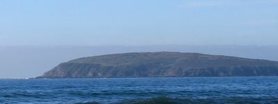
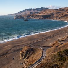
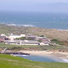
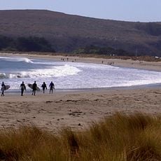
Bodega Head, Coastal promontory and summit in Sonoma County, United States.

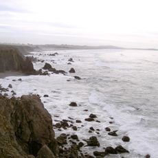
Bodega Head is a rocky promontory on the California coast that rises approximately 265 feet above the Pacific Ocean. The granite formations create dramatic cliffs and form a natural barrier along this stretch of shoreline.

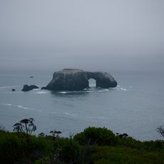
Bodega Head was shaped millions of years ago by volcanic activity that forced granite outcrops through surrounding rock layers to the surface. This ancient geological process continues to define the headland's character today.

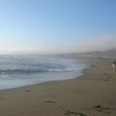
Local Native American communities used this coastal area for generations, establishing temporary camps here to gather food from the ocean and land.

The site is accessible via marked trails that lead from the parking area to several viewpoints along the headland. These paths offer good opportunities to observe migrating gray whales during the winter and early spring months.

The rock composition here includes fragments from the Pacific Plate, making it geologically different from surrounding areas along the continental edge. This rare combination tells the story of powerful tectonic forces that shaped this coast.

The community of curious travelers

AroundUs brings together thousands of curated places, local tips, and hidden gems, enriched daily by 60,000 contributors worldwide.

Start exploring
Location
GPS coordinates
38.31103,-123.06611
Latest update
December 10, 2025 16:24
Around this place
Bohemian Grove
United States of America

Bohemian Grove

18.3 km
Bodega Bay
United States of America

Bodega Bay

6.7 km
United States of America

Running Fence

12.4 km
Korbel Champagne Cellars
United States of America

Korbel Champagne Cellars

23.5 km
Armstrong Redwoods State Natural Reserve
United States of America

Armstrong Redwoods State Natural Reserve

25.7 km
Goat Rock Beach
United States of America

Goat Rock Beach

16 km
East Bay Walls
United States of America

East Bay Walls

14.6 km
Sonoma Coast State Park
United States of America

Sonoma Coast State Park

6.5 km
Greater Farallones National Marine Sanctuary
United States of America

Greater Farallones National Marine Sanctuary

7.1 km
Bodega Marine Reserve
United States of America

Bodega Marine Reserve

449 m
Doran Regional Park
United States of America

Doran Regional Park

2 km
Kistler Vineyards
United States of America

Kistler Vineyards

24.5 km
Bodega Harbor
United States of America

Bodega Harbor

2.1 km
Sonoma Coast State Marine Conservation Area
United States of America

Sonoma Coast State Marine Conservation Area

4.3 km
Tomales Presbyterian Church and Cemetery
United States of America

Tomales Presbyterian Church and Cemetery

15.7 km
Luther Burbank's Gold Ridge Experiment Farm
United States of America

Luther Burbank's Gold Ridge Experiment Farm

22.3 km
Marimar Estate
United States of America

Marimar Estate

18.9 km
United States of America

Estero Americano State Marine Recreational Management Area

5.9 km
Ragle Ranch Regional Park
United States of America

Ragle Ranch Regional Park

21.5 km
Watson School
United States of America

Watson School

12.2 km
United States of America

Estero de San Antonio State Marine Recreational Management Area

8.9 km
Hinds Hotel
United States of America

Hinds Hotel

22.5 km
George A. Strout House
United States of America

George A. Strout House

23.1 km
Petaluma and Santa Rosa Railway Powerhouse
United States of America

Petaluma and Santa Rosa Railway Powerhouse

23.5 km
Church of the Assumption, Tomales
United States of America

Church of the Assumption, Tomales

15.9 km
Doran Beach
United States of America

Doran Beach

2.3 km
Guerneville Bridge
United States of America

Guerneville Bridge

22.1 km
Arched Rock Beach
United States of America

Arched Rock Beach

6.3 km
Show the full map
« Bodega Head - Coastal promontory and summit in Sonoma County, United States » is provided by Around Us (aroundus.com). Images and texts are derived from Wikimedia project under a Creative Commons license. You are allowed to copy, distribute, and modify copies of this page, under the conditions set by the license, as long as this note is clearly visible.

Discover hidden gems everywhere you go!

From secret cafés to breathtaking viewpoints, skip the crowded tourist spots and find places that match your style. Our app makes it easy with voice search, smart filtering, route optimization, and insider tips from travelers worldwide. Download now for the complete mobile experience.

Around Us App Screenshot

A unique approach to discovering new places

Le Figaro

All the places worth exploring

France Info

A tailor-made excursion in just a few clicks

20 Minutes

Around Us
Travel Guide & Maps
Download

Send to your phone

QR Code
1

Open the camera app on your mobile.

2

Point at the QR code with your camera. A notification will appear.

3

Tap the notification to open the link.