Log in to your account

AroundUs is a community-driven map of interesting places, built by curious explorers like you. It grows with every review, story, and photo you share.
Connect to save your favorite spots, contribute locations, and create personalized routes.
Continue with Google
Continue with Apple
Continue with X
Continue with Facebook
Continue with email
By continuing, you accept our Terms and Conditions and our Privacy Policy
Create an account

Estero de San Antonio State Marine Recreational Management Area

Add to collection
Map
Suggest a change
Share

Estero de San Antonio State Marine Recreational Management Area, Marine conservation area in Marin County, California, United States

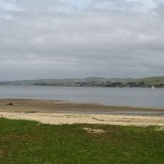
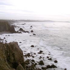
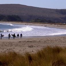
Estero de San Antonio State Marine Recreational Management Area is a protected marine zone north of Dillon Beach featuring mudflats, eelgrass beds, and saltgrass regions that support coastal wildlife. The area encompasses different water conditions and bottom types that create varied habitats along the shore.

The area received official protection status in 2009 when California's fish and wildlife agency designated it as a marine protected area under state conservation legislation. This designation reflected broader efforts to safeguard marine ecosystems across California's waters.

The area was designed through collaboration between local fishing communities, diving enthusiasts, and conservation groups who wanted to protect the marine life along this stretch of coast. Visitors can see how these shared efforts shape how people interact with and care for the water today.

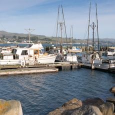
You can kayak, dive, and swim throughout the area, though gathering marine resources is not permitted except for regulated waterfowl hunting. Plan your visit around calm water conditions, as weather and tides can change conditions quickly along this coastal zone.

A natural sandbar develops at the estuary opening during summer months, creating temporary barriers that alter water flow patterns. These formations disappear when seasonal rains return, washing them away and restoring the normal water circulation.

GPS coordinates: 38.27010,-122.97810

Latest update: December 14, 2025 18:41

Photos
Around this place
Bohemian Grove
United States of America

Bohemian Grove

22.1 km
Bodega Bay
United States of America

Bodega Bay

2.5 km
Point Reyes National Seashore
United States of America

Point Reyes National Seashore

24.1 km
United States of America

Running Fence

7.1 km
East Bay Walls
United States of America

East Bay Walls

7.3 km
Sonoma Coast State Park
United States of America

Sonoma Coast State Park

13.8 km
Greater Farallones National Marine Sanctuary
United States of America

Greater Farallones National Marine Sanctuary

8.1 km
Bodega Head
United States of America

Bodega Head

8.9 km
Bodega Marine Reserve
United States of America

Bodega Marine Reserve

8.7 km
Tomales Bay State Park
United States of America

Tomales Bay State Park

18.2 km
Doran Regional Park
United States of America

Doran Regional Park

7.5 km
Kistler Vineyards
United States of America

Kistler Vineyards

23.5 km
Bodega Harbor
United States of America

Bodega Harbor

8.5 km
Sonoma Coast State Marine Conservation Area
United States of America

Sonoma Coast State Marine Conservation Area

11.8 km
Tomales Presbyterian Church and Cemetery
United States of America

Tomales Presbyterian Church and Cemetery

6.8 km
Luther Burbank's Gold Ridge Experiment Farm
United States of America

Luther Burbank's Gold Ridge Experiment Farm

18.8 km
Marimar Estate
United States of America

Marimar Estate

18.2 km
United States of America

Estero Americano State Marine Recreational Management Area

3.6 km
Ragle Ranch Regional Park
United States of America

Ragle Ranch Regional Park

18.7 km
Watson School
United States of America

Watson School

10.2 km
Washoe Creek
United States of America

Washoe Creek

23.2 km
Hinds Hotel
United States of America

Hinds Hotel

21.1 km
George A. Strout House
United States of America

George A. Strout House

19.7 km
Petaluma and Santa Rosa Railway Powerhouse
United States of America

Petaluma and Santa Rosa Railway Powerhouse

19.9 km
Cypress Tree Tunnel
United States of America

Cypress Tree Tunnel

19.8 km
Church of the Assumption, Tomales
United States of America

Church of the Assumption, Tomales

7 km
Doran Beach
United States of America

Doran Beach

7.2 km
Arched Rock Beach
United States of America

Arched Rock Beach

13.7 km
Show the full map
Reviews

Visited this place? Tap the stars to rate it and share your experience / photos with the community! Try now! You can cancel it anytime.

« Estero de San Antonio State Marine Recreational Management Area - Marine conservation area in Marin County, California, United States » is provided by Around Us (aroundus.com). Images and texts are derived from Wikimedia project under a Creative Commons license. You are allowed to copy, distribute, and modify copies of this page, under the conditions set by the license, as long as this note is clearly visible.

Discover hidden gems everywhere you go!

From secret cafés to breathtaking viewpoints, skip the crowded tourist spots and find places that match your style. Our app makes it easy with voice search, smart filtering, route optimization, and insider tips from travelers worldwide. Download now for the complete mobile experience.

Around Us App Screenshot

A unique approach to discovering new places

Le Figaro

All the places worth exploring

France Info

A tailor-made excursion in just a few clicks

20 Minutes