Enable Location

We need your location to show you interesting places around you

Discover nearby places

Find interesting locations and hidden gems around you

Precise directions

Get accurate directions and distances to places

Your location is never shared with other users. It's only used when you tap the location button.

Log in to your account

Start exploring — it's free

Trusted by 62,842 travelers worldwide

Continue with Google
Continue with Apple
or

We will send you a code to connect

By continuing, you accept our Terms and Conditions and our Privacy Policy

Check your inbox

We've sent a pincode in your inbox. Please enter the code below.

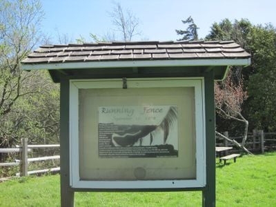
Running Fence, Environmental art installation in Sonoma and Marin Counties, California.

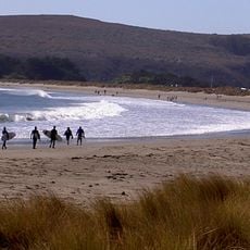
Running Fence was a temporary installation of white nylon fabric that crossed two California counties in 1976. The fabric hung from steel cables between several thousand poles and followed the relief of the hills down to the Pacific coast.

Artists Christo and Jeanne-Claude developed the project from 1972 and conducted negotiations with landowners and authorities. After removal in September 1976, the materials were distributed in all directions or donated.

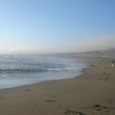
The work lay entirely on private land and could be viewed from public roads, reigniting discussion about art in rural areas. Visitors at the time drove along intersection points with highways and country roads to see the fabric run over hills and valleys.

The installation no longer exists on site, but archival material and photographs show the route and appearance of the fabric. Interested visitors can trace the former route through the area and imagine how the work once crossed the landscape.

The project financed itself entirely through the sale of preparatory drawings and studies by the artists, without external sponsors. After removal, fabric scraps and poles became sought-after souvenirs that are still kept in private collections today.

The community of curious travelers

AroundUs brings together thousands of curated places, local tips, and hidden gems, enriched daily by 60,000 contributors worldwide.

Start exploring
Location
Location
Inception
September 10, 1976
Creator
Christo and Jeanne-Claude
GPS coordinates
38.31780,-122.92400
Latest update
December 20, 2025 15:26
Around this place
Bodega Bay
United States of America

Bodega Bay

8.7 km
East Bay Walls
United States of America

East Bay Walls

13 km
Sonoma Coast State Park
United States of America

Sonoma Coast State Park

14.3 km
Greater Farallones National Marine Sanctuary
United States of America

Greater Farallones National Marine Sanctuary

14.7 km
Bodega Head
United States of America

Bodega Head

12.4 km
Bodega Marine Reserve
United States of America

Bodega Marine Reserve

12.5 km
Doran Regional Park
United States of America

Doran Regional Park

10.4 km
Bodega Harbor
United States of America

Bodega Harbor

10.8 km
Sonoma Coast State Marine Conservation Area
United States of America

Sonoma Coast State Marine Conservation Area

13.1 km
Tomales Presbyterian Church and Cemetery
United States of America

Tomales Presbyterian Church and Cemetery

8.2 km
Luther Burbank's Gold Ridge Experiment Farm
United States of America

Luther Burbank's Gold Ridge Experiment Farm

11.7 km
United States of America

Estero Americano State Marine Recreational Management Area

7.1 km
Ragle Ranch Regional Park
United States of America

Ragle Ranch Regional Park

11.6 km
Watson School
United States of America

Watson School

4.4 km
United States of America

Estero de San Antonio State Marine Recreational Management Area

7.1 km
Hinds Hotel
United States of America

Hinds Hotel

14.3 km
George A. Strout House
United States of America

George A. Strout House

12.6 km
Petaluma and Santa Rosa Railway Powerhouse
United States of America

Petaluma and Santa Rosa Railway Powerhouse

12.8 km
North Salmon Creek Beach
United States of America

North Salmon Creek Beach

13.3 km
Church of the Assumption, Tomales
United States of America

Church of the Assumption, Tomales

8.3 km
Carmel Beach
United States of America

Carmel Beach

14.8 km
Doran Beach
United States of America

Doran Beach

10.1 km
Miwok Beach
United States of America

Miwok Beach

13.5 km
Coleman Beach
United States of America

Coleman Beach

13.9 km
Blue Gums Beach
United States of America

Blue Gums Beach

11.1 km
Arched Rock Beach
United States of America

Arched Rock Beach

14.1 km
South Salmon Creek Beach
United States of America

South Salmon Creek Beach

12.8 km
Driftwood Beach
United States of America

Driftwood Beach

14 km
Show the full map
« Running Fence - Environmental art installation in Sonoma and Marin Counties, California » is provided by Around Us (aroundus.com). Images and texts are derived from Wikimedia project under a Creative Commons license. You are allowed to copy, distribute, and modify copies of this page, under the conditions set by the license, as long as this note is clearly visible.

Discover hidden gems everywhere you go!

From secret cafés to breathtaking viewpoints, skip the crowded tourist spots and find places that match your style. Our app makes it easy with voice search, smart filtering, route optimization, and insider tips from travelers worldwide. Download now for the complete mobile experience.

Around Us App Screenshot

A unique approach to discovering new places

Le Figaro

All the places worth exploring

France Info

A tailor-made excursion in just a few clicks

20 Minutes

Around Us
Travel Guide & Maps
Download

Send to your phone

QR Code
1

Open the camera app on your mobile.

2

Point at the QR code with your camera. A notification will appear.

3

Tap the notification to open the link.