East Bay Walls

Log in to your account

AroundUs is a community-driven map of interesting places, built by curious explorers like you. It grows with every review, story, and photo you share.
Connect to save your favorite spots, contribute locations, and create personalized routes.
By continuing, you accept our Terms and Conditions and our Privacy Policy

East Bay Walls

Add to collection
Map
Suggest a change
Share

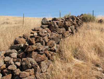
East Bay Walls, Ancient stone walls in San Francisco Bay Area, California.

East Bay Walls are stone structures found throughout the East Bay region that were built without mortar using locally gathered materials. They vary widely in length and in the size of stones used, ranging from small rocks to massive boulders.

The walls were built between 1850 and 1880 as American settlers began populating the region and preparing the land for farming and ranching. They were a practical result of the need to mark property boundaries and manage livestock.

The walls show how early settlers made use of the land and marked their presence in the region. Today visitors can see how these structures fit into the landscape and what role they played for the communities that built them.

The walls can be seen at several accessible locations, including Ed R. Levin County Park and Mission Peak Regional Preserve. The best way to explore them is by hiking through the hills where they appear at many points along the routes.

The walls extend across a large area and have been found in many different parts of northern California, showing that this building style was widespread among settlers. This broad distribution suggests that communities independently developed the same practical solutions for their needs.

GPS coordinates: 38.20560,-122.96600

Latest update: December 7, 2025 20:23

Photos
Around this place
Bodega Bay
United States of America

Bodega Bay

8.3 km
Point Reyes National Seashore
United States of America

Point Reyes National Seashore

17.1 km
Running Fence
United States of America

Running Fence

13 km
Point Reyes Lighthouse
United States of America

Point Reyes Lighthouse

23.9 km
Sonoma Coast State Park
United States of America

Sonoma Coast State Park

20.5 km
Greater Farallones National Marine Sanctuary
United States of America

Greater Farallones National Marine Sanctuary

9.9 km
Bodega Head
United States of America

Bodega Head

14.6 km
Bodega Marine Reserve
United States of America

Bodega Marine Reserve

14.3 km
Tomales Bay State Park
United States of America

Tomales Bay State Park

11.4 km
Doran Regional Park
United States of America

Doran Regional Park

13.8 km
Bodega Harbor
United States of America

Bodega Harbor

15 km
Nicasio Reservoir
United States of America

Nicasio Reservoir

23.4 km
Kule Loklo
United States of America

Kule Loklo

22.8 km
Sonoma Coast State Marine Conservation Area
United States of America

Sonoma Coast State Marine Conservation Area

18.3 km
Tomales Presbyterian Church and Cemetery
United States of America

Tomales Presbyterian Church and Cemetery

6.8 km
Luther Burbank's Gold Ridge Experiment Farm
United States of America

Luther Burbank's Gold Ridge Experiment Farm

24.2 km
Point Reyes Lifeboat Station
United States of America

Point Reyes Lifeboat Station

23.6 km
Marimar Estate
United States of America

Marimar Estate

24.7 km
Estero Americano State Marine Recreational Management Area
United States of America

Estero Americano State Marine Recreational Management Area

10.6 km
Ragle Ranch Regional Park
United States of America

Ragle Ranch Regional Park

24.4 km
Watson School
United States of America

Watson School

16.9 km
Estero de San Antonio State Marine Recreational Management Area
United States of America

Estero de San Antonio State Marine Recreational Management Area

7.3 km
Cypress Tree Tunnel
United States of America

Cypress Tree Tunnel

12.6 km
Church of the Assumption, Tomales
United States of America

Church of the Assumption, Tomales

6.9 km
Doran Beach
United States of America

Doran Beach

13.6 km
Arched Rock Beach
United States of America

Arched Rock Beach

20.3 km
Drakes Bay Historic and Archeological District
United States of America

Drakes Bay Historic and Archeological District

21.9 km
Kenneth C. Patrick Visitor Center
United States of America

Kenneth C. Patrick Visitor Center

19.8 km
Show the full map
Reviews

Visited this place? Tap the stars to rate it and share your experience / photos with the community! Try now! You can cancel it anytime.

« East Bay Walls - Ancient stone walls in San Francisco Bay Area, California » is provided by Around Us (aroundus.com). Images and texts are derived from Wikimedia project under a Creative Commons license. You are allowed to copy, distribute, and modify copies of this page, under the conditions set by the license, as long as this note is clearly visible.

Discover hidden gems everywhere you go!

From secret cafés to breathtaking viewpoints, skip the crowded tourist spots and find places that match your style. Our app makes it easy with voice search, smart filtering, route optimization, and insider tips from travelers worldwide. Download now for the complete mobile experience.

Around Us App Screenshot

A unique approach to discovering new places

Le Figaro

All the places worth exploring

France Info

A tailor-made excursion in just a few clicks

20 Minutes