Enable Location

We need your location to show you interesting places around you

Discover nearby places

Find interesting locations and hidden gems around you

Precise directions

Get accurate directions and distances to places

Your location is never shared with other users. It's only used when you tap the location button.

U.S. Route 50 in California

Log in to your account

Start exploring — it's free

Trusted by 61,365 travelers worldwide

Continue with Google
Continue with Apple
or

We will send you a code to connect

By continuing, you accept our Terms and Conditions and our Privacy Policy

Check your inbox

We've sent a pincode in your inbox. Please enter the code below.

U.S. Route 50 in California

U.S. Route 50 in California, Federal highway section in Yolo County, United States.

Description

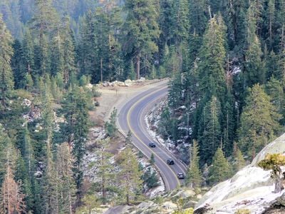
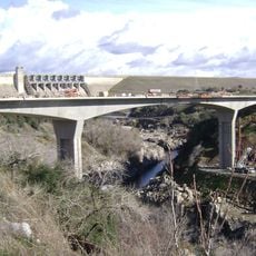
U.S. Route 50 is a four-lane divided federal highway that crosses western Yolo County, connecting West Sacramento to the Sierra Nevada mountains. The section passes through varied landscapes ranging from flat valley areas to steep mountain passes.

History

The road opened in 1926 as part of the original U.S. Highway System, following paths that Native Americans and 1800s gold miners had traveled before. These ancient routes were later developed into a major modern transportation artery.

Culture

The road links farming communities of Yolo County with the Sacramento capital region, serving as a daily connection between rural and urban life for many residents.

Practical

Winter travelers should check weather conditions and carry emergency supplies, as mountain passes may require tire chains during snowy periods. Good vehicle maintenance is especially important in the higher elevation sections.

Did you know?

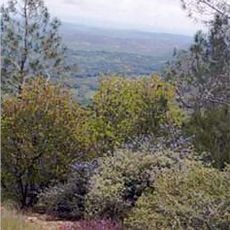
The elevation changes along this stretch are dramatic, starting near sea level in West Sacramento and rising to over 7,000 feet at Echo Summit. This extreme difference creates a visual journey through several distinct climate zones in a single drive.

Location
Location
Inception
1926
Part of
U.S. Route 50
GPS coordinates
38.64208,-121.14796
Latest update
December 20, 2025 14:56

AroundUs brings together thousands of curated places, local tips, and hidden gems, enriched daily by 60,000 contributors worldwide. Discover all places nearby (Yolo County).

Around this place
Folsom State Prison
United States of America

Folsom State Prison

6 km
American River
United States of America

American River

7.6 km
Mather Air Force Base
United States of America

Mather Air Force Base

16.3 km
Folsom Lake
United States of America

Folsom Lake

8.8 km
Folsom Dam
United States of America

Folsom Dam

7.3 km
Aerospace Museum of California
United States of America

Aerospace Museum of California

21.4 km
Folsom Powerhouse State Historic Park
United States of America

Folsom Powerhouse State Historic Park

4.9 km
Folsom Lake State Recreation Area
United States of America

Folsom Lake State Recreation Area

10.1 km
SeaQuest Folsom
United States of America

SeaQuest Folsom

2.5 km
United States of America

Folsom City Zoo Sanctuary

4.9 km
Fair Oaks Bridge
United States of America

Fair Oaks Bridge

10.2 km
Pine Hill Ecological Reserve
United States of America

Pine Hill Ecological Reserve

16.1 km
Safetyville USA
United States of America

Safetyville USA

19.1 km
United States of America

Carpenter Hill

4.2 km
Brighton School
United States of America

Brighton School

18.7 km
Maidu Museum & Historic Site
United States of America

Maidu Museum & Historic Site

13.7 km
Jensen Botanical Gardens
United States of America

Jensen Botanical Gardens

15 km
American River Grange Hall No. 172
United States of America

American River Grange Hall No. 172

12 km
Cohn House
United States of America

Cohn House

4.7 km
Faith Episcopal Church
United States of America

Faith Episcopal Church

12 km
Rusch Botanical Gardens
United States of America

Rusch Botanical Gardens

15.1 km
Sacramento Children's Museum
United States of America

Sacramento Children's Museum

13.2 km
Chaparral Gardens
United States of America

Chaparral Gardens

17 km
Alden Memorial Bridge
United States of America

Alden Memorial Bridge

5.1 km
Scandia Family Fun Center
United States of America

Scandia Family Fun Center

18.9 km
Historic Opera House
United States of America

Historic Opera House

4.7 km
Rainbow Bridge
United States of America

Rainbow Bridge

5.1 km
Folsom Lake Crossing
United States of America

Folsom Lake Crossing

7.1 km
Show the full map
« U.S. Route 50 in California - Federal highway section in Yolo County, United States » is provided by Around Us (aroundus.com). Images and texts are derived from Wikimedia project under a Creative Commons license. You are allowed to copy, distribute, and modify copies of this page, under the conditions set by the license, as long as this note is clearly visible.

Discover hidden gems everywhere you go!

From secret cafés to breathtaking viewpoints, skip the crowded tourist spots and find places that match your style. Our app makes it easy with voice search, smart filtering, route optimization, and insider tips from travelers worldwide. Download now for the complete mobile experience.

Around Us App Screenshot

A unique approach to discovering new places

Le Figaro

All the places worth exploring

France Info

A tailor-made excursion in just a few clicks

20 Minutes

Around Us
Travel Guide & Maps
Download

Send to your phone

QR Code
1

Open the camera app on your mobile.

2

Point at the QR code with your camera. A notification will appear.

3

Tap the notification to open the link.