Enable Location

We need your location to show you interesting places around you

Discover nearby places

Find interesting locations and hidden gems around you

Precise directions

Get accurate directions and distances to places

Your location is never shared with other users. It's only used when you tap the location button.

Log in to your account

Start exploring — it's free

Trusted by 65,806 travelers worldwide

Continue with Google
Continue with Apple
or

We will send you a code to connect

By continuing, you accept our Terms and Conditions and our Privacy Policy

Check your inbox

We've sent a pincode in your inbox. Please enter the code below.

Thunderhill Raceway Park
Discussion Reviews Photo
10k Popularity

Thunderhill Raceway Park, motorsports complex in Sacramento Valley, California, U.S

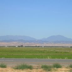
Thunderhill Raceway Park is a motorsport racing track in Glenn County, northern California, roughly two hours north of Sacramento, set among open hills and dry grassland. The facility has several track layouts that can be used for different vehicle classes and racing disciplines.

The track was built in the 1990s, originally intended as a training ground for motorsport fans in northern California. Over time it grew into a regional competition venue that draws drivers from across the state.

The name "Thunderhill" reflects the rolling hills that surround the track in the Sacramento Valley. On race days, the crowd is a mix of serious amateur drivers and professional teams, giving the place a working, no-frills feel rather than that of a polished spectator venue.

The track is fully outdoors, so visiting on a dry day is a good idea, especially in spring and fall when temperatures are comfortable. Public access is generally limited to scheduled event days, so it is worth checking the event calendar in advance.

One of the track configurations stretches to about 5 miles (8 km), making it one of the longest permanent road courses in the US. This length allows endurance races to take place that would not be possible on shorter circuits.

The community of curious travelers

AroundUs brings together thousands of curated places, local tips, and hidden gems, enriched daily by 60,000 contributors worldwide.

Start exploring
Location
GPS coordinates
39.54033,-122.33069
Latest update
March 3, 2026 10:12
Around this place
Mendocino National Forest
United States of America

Mendocino National Forest

41.7 km
Berryessa Snow Mountain National Monument
United States of America

Berryessa Snow Mountain National Monument

53.7 km
Bidwell Mansion State Historic Park
United States of America

Bidwell Mansion State Historic Park

47.1 km
Abbey of New Clairvaux
United States of America

Abbey of New Clairvaux

49.6 km
Sacramento National Wildlife Refuge Complex
United States of America

Sacramento National Wildlife Refuge Complex

17.5 km
Snow Mountain Wilderness
United States of America

Snow Mountain Wilderness

36.3 km
Black Butte Lake
United States of America

Black Butte Lake

29.6 km
Delevan National Wildlife Refuge
United States of America

Delevan National Wildlife Refuge

31.8 km
Colusa National Wildlife Refuge
United States of America

Colusa National Wildlife Refuge

49.3 km
Crabtree Hot Springs, California
United States of America

Crabtree Hot Springs, California

50.6 km
Sacramento River National Wildlife Refuge
United States of America

Sacramento River National Wildlife Refuge

37.2 km
Chico Air Museum
United States of America

Chico Air Museum

50 km
Stony Gorge Dam
United States of America

Stony Gorge Dam

18 km
Snow Mountain East
United States of America

Snow Mountain East

40.2 km
Rice Fork
United States of America

Rice Fork

50.6 km
East Park Dam
United States of America

East Park Dam

25.4 km
Gianella Bridge
United States of America

Gianella Bridge

37.1 km
Sacramento Valley Museum
United States of America

Sacramento Valley Museum

45.6 km
Chico Community Observatory
United States of America

Chico Community Observatory

53.5 km
A. H. Chapman House
United States of America

A. H. Chapman House

47.6 km
Saint John Mountain
United States of America

Saint John Mountain

33.3 km
Silberstein Park Building
United States of America

Silberstein Park Building

47 km
Museum of Northern California Art
United States of America

Museum of Northern California Art

47.1 km
Colusa County Courthouse
United States of America

Colusa County Courthouse

45.7 km
Maywood Woman's Club
United States of America

Maywood Woman's Club

45.1 km
Arboreto de la Universidad de California Campus de Chico
United States of America

Arboreto de la Universidad de California Campus de Chico

46.4 km
Senator Theatre
United States of America

Senator Theatre

47.2 km
Rodgers Theatre
United States of America

Rodgers Theatre

45 km
Show the full map
Reviews
Share your experience

No review yet

Discussions
Start a discussion...

No discussion yet

« Thunderhill Raceway Park - motorsports complex in Sacramento Valley, California, U.S » is provided by Around Us (aroundus.com). Images and texts are derived from Wikimedia project under a Creative Commons license. You are allowed to copy, distribute, and modify copies of this page, under the conditions set by the license, as long as this note is clearly visible.

Discover hidden gems everywhere you go!

From secret cafés to breathtaking viewpoints, skip the crowded tourist spots and find places that match your style. Our app makes it easy with voice search, smart filtering, route optimization, and insider tips from travelers worldwide. Download now for the complete mobile experience.

Around Us App Screenshot

A unique approach to discovering new places

Le Figaro

All the places worth exploring

France Info

A tailor-made excursion in just a few clicks

20 Minutes

Around Us
Travel Guide & Maps
Download

Send to your phone

QR Code
1

Open the camera app on your mobile.

2

Point at the QR code with your camera. A notification will appear.

3

Tap the notification to open the link.