Sutter Buttes

Log in to your account

AroundUs is a community-driven map of interesting places, built by curious explorers like you. It grows with every review, story, and photo you share.
Connect to save your favorite spots, contribute locations, and create personalized routes.
Continue with Google
Continue with Apple
Continue with X
Continue with Facebook
Continue with email
By continuing, you accept our Terms and Conditions and our Privacy Policy
Create an account
Add to collection
Map
Suggest a change
Share

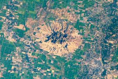
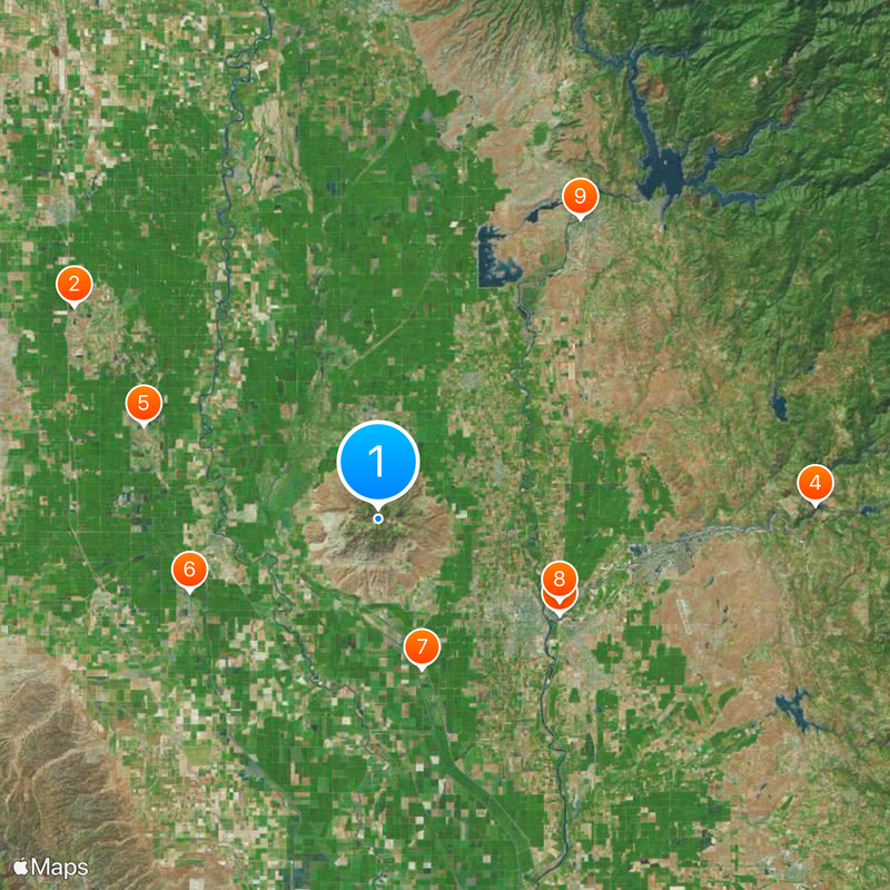
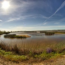
Sutter Buttes, Mountain range and extinct volcano in Sutter County, California.

The Sutter Buttes form a circular complex of eroded volcanic domes rising 2,122 feet (647 m) above the Sacramento Valley plains and represent the smallest mountain range in North America. The structure consists of overlapping volcanic cones concentrated in a single location.

These volcanic cones formed during the early Pleistocene period, about 1.6 million years ago, through a series of eruptions spanning roughly 200,000 years. No volcanic activity has occurred at the site since that distant past.

The Nisenan, Maidu, and Wintun peoples used these mountains as seasonal gathering places and wove them into their creation stories. The landscape held deep spiritual significance for the communities who lived nearby.

Access is only available through authorized guided tours, as most of the land is privately owned by local farmers. Visitors must arrange in advance and follow established access procedures.

Between 1960 and 1965, the United States Air Force operated a Titan intercontinental ballistic missile launch site on the northern side. The facility was decommissioned and left no visible traces.

Location: Sutter County

Elevation above the sea: 647 m

GPS coordinates: 39.22639,-121.81056

Latest update: December 14, 2025 19:33

Photos
Around this place
Sacramento National Wildlife Refuge Complex
United States of America

Sacramento National Wildlife Refuge Complex

39.5 km
Bok Kai Temple
United States of America

Bok Kai Temple

21.8 km
Englebright Lake
United States of America

Englebright Lake

46.6 km
Delevan National Wildlife Refuge
United States of America

Delevan National Wildlife Refuge

27 km
Colusa National Wildlife Refuge
United States of America

Colusa National Wildlife Refuge

21.5 km
Sutter National Wildlife Refuge
United States of America

Sutter National Wildlife Refuge

16.7 km
Ellis Lake
United States of America

Ellis Lake

21.2 km
Oroville Chinese Temple
United States of America

Oroville Chinese Temple

38.5 km
Old Bidwell Bar Bridge
United States of America

Old Bidwell Bar Bridge

46.3 km
Sacramento Valley Museum
United States of America

Sacramento Valley Museum

31.4 km
Community Memorial Museum of Sutter County
United States of America

Community Memorial Museum of Sutter County

17.5 km
Live Oak Historic Commercial District
United States of America

Live Oak Historic Commercial District

14 km
Yuba City Astronomical Observatory
United States of America

Yuba City Astronomical Observatory

19.7 km
Grand Island Shrine
United States of America

Grand Island Shrine

16.4 km
Hart Building
United States of America

Hart Building

21.5 km
Collins Lake Beach
United States of America

Collins Lake Beach

43.7 km
Packard Library
United States of America

Packard Library

21.5 km
Colusa County Courthouse
United States of America

Colusa County Courthouse

17.2 km
Wheatland Masonic Temple
United States of America

Wheatland Masonic Temple

41.2 km
Marysville Historic Commercial District
United States of America

Marysville Historic Commercial District

21.5 km
Oroville Carnegie Library
United States of America

Oroville Carnegie Library

38.5 km
West Butte Schoolhouse
United States of America

West Butte Schoolhouse

7.4 km
Oroville Chinese Temple
United States of America

Oroville Chinese Temple

38.5 km
Oroville State Theatre
United States of America

Oroville State Theatre

38.7 km
Beatson Falls
United States of America

Beatson Falls

45.1 km
Bayliss Carnegie Library
United States of America

Bayliss Carnegie Library

44.6 km
Sacramento National Wildlife Refuge
United States of America

Sacramento National Wildlife Refuge

36.7 km
Yuba County Library
United States of America

Yuba County Library

21.6 km
Show the full map
Reviews

Visited this place? Tap the stars to rate it and share your experience / photos with the community! Try now! You can cancel it anytime.

« Sutter Buttes - Mountain range and extinct volcano in Sutter County, California » is provided by Around Us (aroundus.com). Images and texts are derived from Wikimedia project under a Creative Commons license. You are allowed to copy, distribute, and modify copies of this page, under the conditions set by the license, as long as this note is clearly visible.

Discover hidden gems everywhere you go!

From secret cafés to breathtaking viewpoints, skip the crowded tourist spots and find places that match your style. Our app makes it easy with voice search, smart filtering, route optimization, and insider tips from travelers worldwide. Download now for the complete mobile experience.

Around Us App Screenshot

A unique approach to discovering new places

Le Figaro

All the places worth exploring

France Info

A tailor-made excursion in just a few clicks

20 Minutes