Chest opened
+${chestReward.xp} XP
Explorer
NOUVEAU ×${chestReward.collectible.quantity}
tapez pour fermer
Chest locked

Open chests in the app

Around Us is built for your phone — chests unlock when you walk, explore and capture nearby places.

Enable Location

We need your location to show you interesting places around you

Discover nearby places

Find interesting locations and hidden gems around you

Precise directions

Get accurate directions and distances to places

Your location is never shared with other users. It's only used when you tap the location button.

Log in to your account

Start exploring — it's free

Trusted by 72,894 travelers worldwide

Continue with Google
Continue with Apple
or

We will send you a code to connect

By continuing, you accept our Terms and Conditions and our Privacy Policy

Check your inbox

We've sent a pincode in your inbox. Please enter the code below.

Clear Lake
Discussion Reviews Photo
1.5k Popularity

Clear Lake, Volcanic lake in Douglas County, Oregon, US

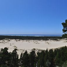
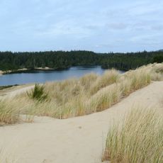
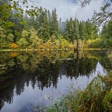
Clear Lake is a volcanic lake in Douglas County surrounded by dense evergreen forest and mountain peaks within the Willamette National Forest. The water spreads across a wide expanse with steep, heavily forested shorelines.

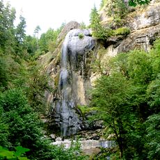
This lake formed thousands of years ago through volcanic activity that shaped the region's geological landscape. The volcanic processes created the basin that holds the water today.

The lake area holds deep meaning for Native American communities who have long depended on its waters for food and survival. This connection to the land remains visible in how the landscape is used and respected today.

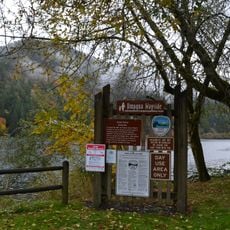
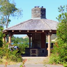
The shoreline has multiple trail access points, camping areas, and boat ramps that are open year-round from sunrise to sunset. The facilities allow visitors to enjoy different outdoor activities at this location.

The water comes from mountain springs and seasonal snowmelt, maintaining steady temperatures year-round. This natural cycle supports a stable ecosystem home to species rarely found elsewhere.

The community of curious travelers

AroundUs brings together thousands of curated places, local tips, and hidden gems, enriched daily by 60,000 contributors worldwide.

Start exploring
Location
GPS coordinates
43.64375,-124.18244
Latest update
December 14, 2025 15:00
Around this place
Oregon Dunes National Recreation Area
United States of America

Oregon Dunes National Recreation Area

9 km
Jessie M. Honeyman Memorial State Park
United States of America

Jessie M. Honeyman Memorial State Park

32.3 km
Conde McCullough Memorial Bridge
United States of America

Conde McCullough Memorial Bridge

24.4 km
Umpqua River Light
United States of America

Umpqua River Light

2.4 km
Elliott State Forest
United States of America

Elliott State Forest

14.8 km
William M. Tugman State Park
United States of America

William M. Tugman State Park

4.8 km
Coast Guard Air Station North Bend
United States of America

Coast Guard Air Station North Bend

26.5 km
Egyptian Theatre
United States of America

Egyptian Theatre

30.9 km
Devil's Staircase Wilderness
United States of America

Devil's Staircase Wilderness

22.8 km
Golden and Silver Falls State Natural Area
United States of America

Golden and Silver Falls State Natural Area

26.9 km
Umpqua State Scenic Corridor
United States of America

Umpqua State Scenic Corridor

22.3 km
Umpqua River Bridge
United States of America

Umpqua River Bridge

9.9 km
Dean Creek Wildlife Area
United States of America

Dean Creek Wildlife Area

12.9 km
Haynes Inlet Bridge
United States of America

Haynes Inlet Bridge

22.9 km
Sand Dunes Frontier
United States of America

Sand Dunes Frontier

30.6 km
Coos Bay National Bank Building
United States of America

Coos Bay National Bank Building

30.8 km
Coos History Museum
United States of America

Coos History Museum

29.9 km
J. S. Coke Building
United States of America

J. S. Coke Building

30.8 km
Chandler Hotel and Annex
United States of America

Chandler Hotel and Annex

30.8 km
Eye of the Needle
United States of America

Eye of the Needle

32.5 km
Port Theater
United States of America

Port Theater

26.6 km
Liberty Theatre
United States of America

Liberty Theatre

26.7 km
Chandler Bridge
United States of America

Chandler Bridge

31 km
North Beach
United States of America

North Beach

30.8 km
Jessie M. Honeyman Memorial State Park Hexagonal Kitchen Shelter
United States of America

Jessie M. Honeyman Memorial State Park Hexagonal Kitchen Shelter

32.5 km
Jessie M. Honeyman Memorial State Park Historic District
United States of America

Jessie M. Honeyman Memorial State Park Historic District

32.5 km
Gardiner Historic District
United States of America

Gardiner Historic District

11.3 km
Gardiner Cemetery
United States of America

Gardiner Cemetery

11.8 km
Show the full map
Reviews
Share your experience

No review yet

Discussions
Start a discussion...

No discussion yet

« Clear Lake - Volcanic lake in Douglas County, Oregon, US » is provided by Around Us (aroundus.com). Images and texts are derived from Wikimedia project under a Creative Commons license. You are allowed to copy, distribute, and modify copies of this page, under the conditions set by the license, as long as this note is clearly visible.

Discover hidden gems everywhere you go!

From secret cafés to breathtaking viewpoints, skip the crowded tourist spots and find places that match your style. Our app makes it easy with voice search, smart filtering, route optimization, and insider tips from travelers worldwide. Download now for the complete mobile experience.

Around Us App Screenshot

A unique approach to discovering new places

Le Figaro

All the places worth exploring

France Info

A tailor-made excursion in just a few clicks

20 Minutes

Around Us
Travel Guide & Maps
Download

Send to your phone

QR Code
1

Open the camera app on your mobile.

2

Point at the QR code with your camera. A notification will appear.

3

Tap the notification to open the link.