Chest opened
+${chestReward.xp} XP
Explorer
NOUVEAU ×${chestReward.collectible.quantity}
tapez pour fermer
Chest locked

Open chests in the app

Around Us is built for your phone — chests unlock when you walk, explore and capture nearby places.

Enable Location

We need your location to show you interesting places around you

Discover nearby places

Find interesting locations and hidden gems around you

Precise directions

Get accurate directions and distances to places

Your location is never shared with other users. It's only used when you tap the location button.

Spencer Butte

Log in to your account

Start exploring — it's free

Trusted by 72,876 travelers worldwide

Continue with Google
Continue with Apple
or

We will send you a code to connect

By continuing, you accept our Terms and Conditions and our Privacy Policy

Check your inbox

We've sent a pincode in your inbox. Please enter the code below.

Spencer Butte
Discussion Reviews 1 Photos
9.5k Popularity

Spencer Butte, Forested hill in Eugene, United States.

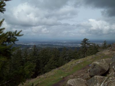
Spencer Butte is a forested hill south of Eugene, Oregon, rising to exposed basalt rock at its summit. From the top, the view opens over surrounding forests and valleys, and on clear days the Cascade Mountains are visible in the distance.

The Kalapuya people lived in this region for centuries and knew this hill as part of their everyday landscape. In the 19th century, European settlement changed how the land was used, and the site eventually came under protection as a regional park.

The name Spencer Butte comes from an early American settler, not from the Kalapuya people who lived on this land for centuries. At the top, visitors have over time left small stone cairns as a mark of their climb.

The hill sits within Spencer Butte Park south of Eugene and can be reached from several trailheads. The climb is steep, especially near the top, so sturdy shoes and enough water are a good idea before you start.

The basalt at the summit is part of an ancient lava flow that shaped the surface of what is now Oregon millions of years ago. Some of the rocks have been worn by wind and frost into unusual shapes that are easy to notice on the final stretch of the climb.

The community of curious travelers

AroundUs brings together thousands of curated places, local tips, and hidden gems, enriched daily by 60,000 contributors worldwide.

Start exploring
Location
GPS coordinates
43.98360,-123.09700
Latest update
March 3, 2026 10:13
Around this place
Hayward Field
United States of America

Hayward Field

6.9 km
Cascades Raptor Center
United States of America

Cascades Raptor Center

1.4 km
McArthur Court
United States of America

McArthur Court

6.7 km
Jordan Schnitzer Museum of Art
United States of America

Jordan Schnitzer Museum of Art

6.9 km
Civic Stadium
United States of America

Civic Stadium

5.9 km
Knight Library
United States of America

Knight Library

6.8 km
Jane Sanders Stadium
United States of America

Jane Sanders Stadium

6.6 km
Temple Beth Israel
United States of America

Temple Beth Israel

5 km
Hendricks Park
United States of America

Hendricks Park

6.5 km
The Pioneer Mother
United States of America

The Pioneer Mother

7 km
University of Oregon Museum of Natural and Cultural History
United States of America

University of Oregon Museum of Natural and Cultural History

7 km
Gerlinger Hall
United States of America

Gerlinger Hall

6.9 km
Kincaid Field
United States of America

Kincaid Field

7 km
Johnson Hall
United States of America

Johnson Hall

7.1 km
Wayne Morse Farm
United States of America

Wayne Morse Farm

4.4 km
MarAbel B. Frohnmayer Music Building
United States of America

MarAbel B. Frohnmayer Music Building

6.5 km
Woodrow Wilson Junior High School
United States of America

Woodrow Wilson Junior High School

7 km
First Congregational Church
United States of America

First Congregational Church

7 km
A. V. Peters House
United States of America

A. V. Peters House

6.5 km
Christian–Patterson Rental Property
United States of America

Christian–Patterson Rental Property

6.5 km
Rice Apartments
United States of America

Rice Apartments

6.9 km
Daniel and Catherine Christian House
United States of America

Daniel and Catherine Christian House

7 km
Wilder Apartments
United States of America

Wilder Apartments

7 km
Benjamin Franklin Dorris House
United States of America

Benjamin Franklin Dorris House

6.6 km
Abraham and Phoebe Ball House
United States of America

Abraham and Phoebe Ball House

6.9 km
Lane County Clerk's Building
United States of America

Lane County Clerk's Building

6.8 km
Patterson–Stratton House
United States of America

Patterson–Stratton House

6.5 km
Clarence and Ethel Boyer House
United States of America

Clarence and Ethel Boyer House

6.1 km
Show the full map
Reviews
Share your experience

No review yet

Discussions
Start a discussion...

No discussion yet

« Spencer Butte - Forested hill in Eugene, United States » is provided by Around Us (aroundus.com). Images and texts are derived from Wikimedia project under a Creative Commons license. You are allowed to copy, distribute, and modify copies of this page, under the conditions set by the license, as long as this note is clearly visible.

Discover hidden gems everywhere you go!

From secret cafés to breathtaking viewpoints, skip the crowded tourist spots and find places that match your style. Our app makes it easy with voice search, smart filtering, route optimization, and insider tips from travelers worldwide. Download now for the complete mobile experience.

Around Us App Screenshot

A unique approach to discovering new places

Le Figaro

All the places worth exploring

France Info

A tailor-made excursion in just a few clicks

20 Minutes

Around Us
Travel Guide & Maps
Download

Send to your phone

QR Code
1

Open the camera app on your mobile.

2

Point at the QR code with your camera. A notification will appear.

3

Tap the notification to open the link.