Cline Falls State Scenic Viewpoint

Log in to your account

AroundUs is a community-driven map of interesting places, built by curious explorers like you. It grows with every review, story, and photo you share.
Connect to save your favorite spots, contribute locations, and create personalized routes.
Continue with Google
Continue with Apple
Continue with X
Continue with Facebook
Continue with email
By continuing, you accept our Terms and Conditions and our Privacy Policy
Create an account

Cline Falls State Scenic Viewpoint

Add to collection
Map
Suggest a change
Share

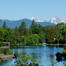
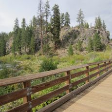
Cline Falls State Scenic Viewpoint, State park at Deschutes River banks near Redmond, Oregon.

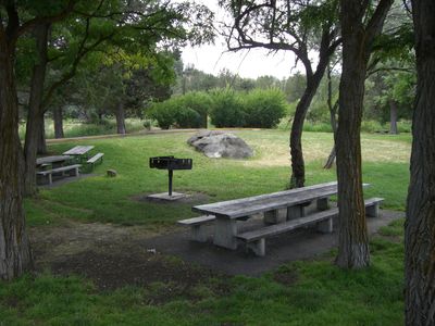
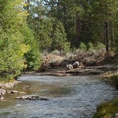
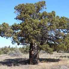
Cline Falls State Scenic Viewpoint is a 9-acre park situated along the Deschutes River near Redmond. The space features open lawns bordered by ponderosa pine, western juniper, poplar, and locust trees that extend down to the water's edge.

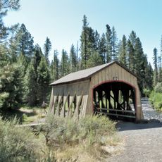
The land was purchased by the Highway Commission in 1936 for gravel extraction but was transferred to the Parks Division in 1956 following a highway realignment. This change of purpose transformed the site from industrial use into a public recreation area.

The park serves as a main recreation spot where Redmond residents swim in deep pools and wade in shallow coves during warm months. Families gather on the open lawns to picnic and spend time together by the river.

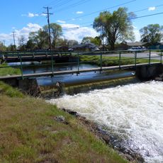
Designated fishing spots are available throughout the park, with pools and shallow areas around large rocks that serve as natural habitats for rainbow and brown trout. Wear sturdy shoes and watch for slippery surfaces along the banks, particularly during high water periods.

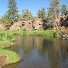
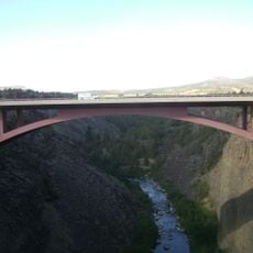
This location marks the finish point of a paddling route starting from Tumalo State Park that spans about 14 miles through varying water conditions. Many paddlers use this spot as their destination after hours on the river.

Location: Oregon

Website: https://stateparks.oregon.gov/index.cfm?do=park.profile&parkId=30

GPS coordinates: 44.26870,-121.25600

Latest update: December 10, 2025 20:03

Photos
Around this place
Smith Rock State Park
United States of America

Smith Rock State Park

14.6 km
Pilot Butte
United States of America

Pilot Butte

23.3 km
Petersen Rock Garden
United States of America

Petersen Rock Garden

7.3 km
Tumalo State Park
United States of America

Tumalo State Park

16.9 km
Mirror Pond
United States of America

Mirror Pond

23.5 km
Crooked River High Bridge
United States of America

Crooked River High Bridge

14.6 km
Peter Skene Ogden State Scenic Viewpoint
United States of America

Peter Skene Ogden State Scenic Viewpoint

14.5 km
Old St. Francis School
United States of America

Old St. Francis School

24.1 km
Crooked River Railroad Bridge
United States of America

Crooked River Railroad Bridge

14.4 km
Crooked River Gorge
United States of America

Crooked River Gorge

16.6 km
Sisters State Park
United States of America

Sisters State Park

22.6 km
Tower Theatre
United States of America

Tower Theatre

23.9 km
Rex T. Barber Veterans Memorial Bridge
United States of America

Rex T. Barber Veterans Memorial Bridge

14.7 km
Thomas McCann House
United States of America

Thomas McCann House

24.1 km
Redmond–Bend Juniper State Scenic Corridor
United States of America

Redmond–Bend Juniper State Scenic Corridor

9.5 km
George Palmer and Dorothy Binney Putnam House
United States of America

George Palmer and Dorothy Binney Putnam House

24 km
Milton Odem House
United States of America

Milton Odem House

6 km
Goodwillie–Allen House
United States of America

Goodwillie–Allen House

23.8 km
First Presbyterian Church of Redmond
United States of America

First Presbyterian Church of Redmond

6.5 km
Charles Boyd Homestead Group
United States of America

Charles Boyd Homestead Group

20.9 km
Rock O' the Range Bridge
United States of America

Rock O' the Range Bridge

16.4 km
Old U.S. Post Office
United States of America

Old U.S. Post Office

23.9 km
B. A. and Ruth Stover House
United States of America

B. A. and Ruth Stover House

23.6 km
Robert D. Moore House
United States of America

Robert D. Moore House

24 km
Emil and Ottilie Wienecke House
United States of America

Emil and Ottilie Wienecke House

23.7 km
Deschutes River Trail
United States of America

Deschutes River Trail

19.7 km
Hixon Crossing Covered Bridge
United States of America

Hixon Crossing Covered Bridge

24 km
Pilot Butte Canal Downtown Redmond Segment
United States of America

Pilot Butte Canal Downtown Redmond Segment

7.3 km
Show the full map
Reviews

Visited this place? Tap the stars to rate it and share your experience / photos with the community! Try now! You can cancel it anytime.

« Cline Falls State Scenic Viewpoint - State park at Deschutes River banks near Redmond, Oregon » is provided by Around Us (aroundus.com). Images and texts are derived from Wikimedia project under a Creative Commons license. You are allowed to copy, distribute, and modify copies of this page, under the conditions set by the license, as long as this note is clearly visible.

Discover hidden gems everywhere you go!

From secret cafés to breathtaking viewpoints, skip the crowded tourist spots and find places that match your style. Our app makes it easy with voice search, smart filtering, route optimization, and insider tips from travelers worldwide. Download now for the complete mobile experience.

Around Us App Screenshot

A unique approach to discovering new places

Le Figaro

All the places worth exploring

France Info

A tailor-made excursion in just a few clicks

20 Minutes