Rex T. Barber Veterans Memorial Bridge

Log in to your account

AroundUs is a community-driven map of interesting places, built by curious explorers like you. It grows with every review, story, and photo you share.
Connect to save your favorite spots, contribute locations, and create personalized routes.
Continue with Google
Continue with Apple
Continue with X
Continue with Facebook
Continue with email
By continuing, you accept our Terms and Conditions and our Privacy Policy
Create an account

Rex T. Barber Veterans Memorial Bridge

Add to collection
Map
Suggest a change
Share

Rex T. Barber Veterans Memorial Bridge, Arch bridge in Jefferson County, Oregon, United States

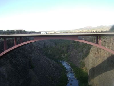
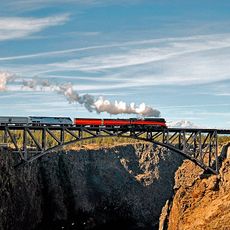
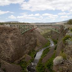
The Rex T. Barber Veterans Memorial Bridge is an arch bridge that crosses the Crooked River gorge, spanning the canyon with significant height and distance. It now carries the main highway traffic that connects communities across central Oregon.

This crossing opened in 2000 and replaced an earlier structure that had served the same canyon location for many decades. The dedication to a local World War II figure came a few years after the new bridge was completed.

The bridge serves as a recognized memorial site where the community acknowledges military service through its naming and periodic commemorative gatherings. This recognition is woven into how people speak about and experience this crossing in their daily lives.

The bridge carries regular traffic year-round as the primary route across the gorge, so expect steady vehicle movement. Walking access and overlook areas may be available nearby for those wishing to view or photograph the structure.

The construction techniques used here became a reference model for later bridge projects across the country. Engineers studied these methods, making this structure an important milestone in how modern spans are built.

Location: Oregon

Inception: 2000

Official opening: 2000

GPS coordinates: 44.39320,-121.19300

Latest update: December 13, 2025 12:23

Photos
Around this place
Smith Rock State Park
United States of America

Smith Rock State Park

5.1 km
Lake Billy Chinook
United States of America

Lake Billy Chinook

25.7 km
The Cove Palisades State Park
United States of America

The Cove Palisades State Park

24.3 km
Petersen Rock Garden
United States of America

Petersen Rock Garden

21.9 km
Cline Falls State Scenic Viewpoint
United States of America

Cline Falls State Scenic Viewpoint

14.7 km
Crooked River High Bridge
United States of America

Crooked River High Bridge

155 m
Peter Skene Ogden State Scenic Viewpoint
United States of America

Peter Skene Ogden State Scenic Viewpoint

207 m
Crooked River Railroad Bridge
United States of America

Crooked River Railroad Bridge

334 m
Crooked River Gorge
United States of America

Crooked River Gorge

4 km
Sisters State Park
United States of America

Sisters State Park

29.9 km
Redmond–Bend Juniper State Scenic Corridor
United States of America

Redmond–Bend Juniper State Scenic Corridor

23.6 km
Ochoco State Scenic Viewpoint
United States of America

Ochoco State Scenic Viewpoint

27.7 km
Milton Odem House
United States of America

Milton Odem House

13.6 km
New Redmond Hotel
United States of America

New Redmond Hotel

13.5 km
First Presbyterian Church of Redmond
United States of America

First Presbyterian Church of Redmond

13.3 km
Grizzly Mountain
United States of America

Grizzly Mountain

19.5 km
Crook County Courthouse
United States of America

Crook County Courthouse

29.6 km
A. R. Bowman Memorial Museum
United States of America

A. R. Bowman Memorial Museum

29.3 km
Sisters High School
United States of America

Sisters High School

30.2 km
Rock O' the Range Bridge
United States of America

Rock O' the Range Bridge

31 km
Thomas M. Baldwin House
United States of America

Thomas M. Baldwin House

29.3 km
Old First National Bank of Prineville
United States of America

Old First National Bank of Prineville

29.3 km
Crook County Bank Building
United States of America

Crook County Bank Building

29.3 km
Marion Reed Elliott House
United States of America

Marion Reed Elliott House

29.3 km
Lamonta Compound
United States of America

Lamonta Compound

28.6 km
Max and Ollie Lueddemann House
United States of America

Max and Ollie Lueddemann House

27.5 km
Pine Theater
United States of America

Pine Theater

29.3 km
Pilot Butte Canal Downtown Redmond Segment
United States of America

Pilot Butte Canal Downtown Redmond Segment

11.8 km
Show the full map
Reviews

Visited this place? Tap the stars to rate it and share your experience / photos with the community! Try now! You can cancel it anytime.

« Rex T. Barber Veterans Memorial Bridge - Arch bridge in Jefferson County, Oregon, United States » is provided by Around Us (aroundus.com). Images and texts are derived from Wikimedia project under a Creative Commons license. You are allowed to copy, distribute, and modify copies of this page, under the conditions set by the license, as long as this note is clearly visible.

Discover hidden gems everywhere you go!

From secret cafés to breathtaking viewpoints, skip the crowded tourist spots and find places that match your style. Our app makes it easy with voice search, smart filtering, route optimization, and insider tips from travelers worldwide. Download now for the complete mobile experience.

Around Us App Screenshot

A unique approach to discovering new places

Le Figaro

All the places worth exploring

France Info

A tailor-made excursion in just a few clicks

20 Minutes