Grizzly Mountain

Log in to your account

AroundUs is a community-driven map of interesting places, built by curious explorers like you. It grows with every review, story, and photo you share.
Connect to save your favorite spots, contribute locations, and create personalized routes.
By continuing, you accept our Terms and Conditions and our Privacy Policy
Add to collection
Map
Suggest a change
Share

Grizzly Mountain, Mountain summit in Crook County, Oregon, US.
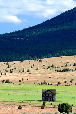
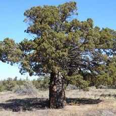
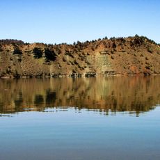
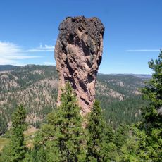
Grizzly Mountain rises to an elevation of 5,629 feet with steep slopes composed of welded tuff, featuring pine and juniper trees on its northern face.

The mountain formed as part of the Crooked River caldera through volcanic processes that deposited layers of compacted ash, creating the current geological formation.

Local outdoor enthusiasts regularly trek to the summit during winter months when larger peaks become inaccessible, maintaining a tradition of year-round mountaineering.

Visitors can access the mountain via a road on the southeast side, with the final ascent requiring proper climbing equipment due to steep scree sections.

The summit provides clear views of multiple Cascade peaks including Mount Hood and Mount Bachelor, while transmission towers mark the highest point.

Location: Oregon

GPS coordinates: 44.43818,-120.95559

Latest update: March 17, 2025 19:58

Photos
Around this place
Smith Rock State Park
United States of America

Smith Rock State Park

16.4 km
Lake Billy Chinook
United States of America

Lake Billy Chinook

36.6 km
The Cove Palisades State Park
United States of America

The Cove Palisades State Park

31.4 km
Petersen Rock Garden
United States of America

Petersen Rock Garden

35.8 km
Cline Falls State Scenic Viewpoint
United States of America

Cline Falls State Scenic Viewpoint

30.5 km
Crooked River High Bridge
United States of America

Crooked River High Bridge

19.6 km
Peter Skene Ogden State Scenic Viewpoint
United States of America

Peter Skene Ogden State Scenic Viewpoint

19.6 km
Crooked River Railroad Bridge
United States of America

Crooked River Railroad Bridge

19.8 km
Pelton Dam
United States of America

Pelton Dam

35.9 km
Crooked River Gorge
United States of America

Crooked River Gorge

22 km
Mill Creek Wilderness
United States of America

Mill Creek Wilderness

34.4 km
Rex T. Barber Veterans Memorial Bridge
United States of America

Rex T. Barber Veterans Memorial Bridge

19.5 km
Redmond–Bend Juniper State Scenic Corridor
United States of America

Redmond–Bend Juniper State Scenic Corridor

36.3 km
Ochoco State Scenic Viewpoint
United States of America

Ochoco State Scenic Viewpoint

16.8 km
Prineville Reservoir Wildlife Area
United States of America

Prineville Reservoir Wildlife Area

36.9 km
Milton Odem House
United States of America

Milton Odem House

25.8 km
First Presbyterian Church of Redmond
United States of America

First Presbyterian Church of Redmond

25.2 km
Crook County Courthouse
United States of America

Crook County Courthouse

17.5 km
A. R. Bowman Memorial Museum
United States of America

A. R. Bowman Memorial Museum

17.4 km
Thomas M. Baldwin House
United States of America

Thomas M. Baldwin House

17.5 km
Old First National Bank of Prineville
United States of America

Old First National Bank of Prineville

17.4 km
Crook County Bank Building
United States of America

Crook County Bank Building

17.4 km
Marion Reed Elliott House
United States of America

Marion Reed Elliott House

17.5 km
Lamonta Compound
United States of America

Lamonta Compound

16.4 km
Max and Ollie Lueddemann House
United States of America

Max and Ollie Lueddemann House

25.7 km
Pine Theater
United States of America

Pine Theater

17.4 km
Pilot Butte Canal Downtown Redmond Segment
United States of America

Pilot Butte Canal Downtown Redmond Segment

23.7 km
Stein's Pillar
United States of America

Stein's Pillar

26.9 km
Show the full map
Reviews

Visited this place? Tap the stars to rate it and share your experience / photos with the community! Try now! You can cancel it anytime.

« Grizzly Mountain - Mountain summit in Crook County, Oregon, US » is provided by Around Us (aroundus.com). Images and texts are derived from Wikimedia project under a Creative Commons license. You are allowed to copy, distribute, and modify copies of this page, under the conditions set by the license, as long as this note is clearly visible.

Discover hidden gems everywhere you go!

From secret cafés to breathtaking viewpoints, skip the crowded tourist spots and find places that match your style. Our app makes it easy with voice search, smart filtering, route optimization, and insider tips from travelers worldwide. Download now for the complete mobile experience.

Around Us App Screenshot

A unique approach to discovering new places

Le Figaro

All the places worth exploring

France Info

A tailor-made excursion in just a few clicks

20 Minutes