Mill Creek Wilderness

Log in to your account

AroundUs is a community-driven map of interesting places, built by curious explorers like you. It grows with every review, story, and photo you share.
Connect to save your favorite spots, contribute locations, and create personalized routes.
Continue with Google
Continue with Apple
Continue with X
Continue with Facebook
Continue with email
By continuing, you accept our Terms and Conditions and our Privacy Policy
Create an account
Add to collection
Map
Suggest a change
Share

Mill Creek Wilderness, US Wilderness Area in Ochoco National Forest, Oregon.

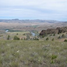
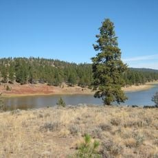
Mill Creek Wilderness is a protected area in Oregon's Ochoco National Forest featuring steep mountain slopes, dense forest cover, and open alpine meadows. Numerous creeks run through the terrain, supporting a variety of plant species throughout the landscape.

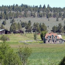
This area received federal protection in 1984, ending industrial use of land that had supported the county's first sawmill along the creek. That mill had helped supply lumber to pioneers establishing settlements nearby.

The wilderness maintains strict preservation protocols, allowing visitors to experience untouched natural environments while practicing Leave No Trace principles.

Several trailheads offer entry points to hiking routes ranging from easy to challenging. Winter weather from December through March typically closes or limits trail access in the higher elevations.

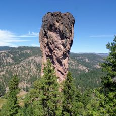
Twin Pillars, two volcanic rock formations, stand about 200 feet tall within this protected area. These distinctive geological features serve as natural landmarks that many hikers use for orientation while exploring the backcountry.

Location: Oregon

GPS coordinates: 44.47750,-120.52600

Latest update: December 12, 2025 17:42

Photos
Around this place
Smith Rock State Park
United States of America

Smith Rock State Park

50.1 km
Painted Hills
United States of America

Painted Hills

28.7 km
Crooked River High Bridge
United States of America

Crooked River High Bridge

53.9 km
Peter Skene Ogden State Scenic Viewpoint
United States of America

Peter Skene Ogden State Scenic Viewpoint

53.9 km
Crooked River Railroad Bridge
United States of America

Crooked River Railroad Bridge

54.1 km
Pelton Dam
United States of America

Pelton Dam

60.9 km
Crooked River Gorge
United States of America

Crooked River Gorge

56.4 km
Bridge Creek Wilderness
United States of America

Bridge Creek Wilderness

24 km
Spring Basin Wilderness
United States of America

Spring Basin Wilderness

48.1 km
Rex T. Barber Veterans Memorial Bridge
United States of America

Rex T. Barber Veterans Memorial Bridge

53.8 km
Ochoco State Scenic Viewpoint
United States of America

Ochoco State Scenic Viewpoint

33.8 km
Prineville Reservoir Wildlife Area
United States of America

Prineville Reservoir Wildlife Area

41.2 km
Milton Odem House
United States of America

Milton Odem House

57 km
Roba Ranch
United States of America

Roba Ranch

50.2 km
First Presbyterian Church of Redmond
United States of America

First Presbyterian Church of Redmond

56.4 km
Grizzly Mountain
United States of America

Grizzly Mountain

34.4 km
Crook County Courthouse
United States of America

Crook County Courthouse

31.9 km
Antelope Flat Reservoir
United States of America

Antelope Flat Reservoir

53.7 km
A. R. Bowman Memorial Museum
United States of America

A. R. Bowman Memorial Museum

32.1 km
Thomas M. Baldwin House
United States of America

Thomas M. Baldwin House

32.3 km
Old First National Bank of Prineville
United States of America

Old First National Bank of Prineville

32.1 km
Crook County Bank Building
United States of America

Crook County Bank Building

32.1 km
Marion Reed Elliott House
United States of America

Marion Reed Elliott House

32.3 km
Lamonta Compound
United States of America

Lamonta Compound

32 km
Max and Ollie Lueddemann House
United States of America

Max and Ollie Lueddemann House

50.6 km
Pine Theater
United States of America

Pine Theater

32.1 km
Pilot Butte Canal Downtown Redmond Segment
United States of America

Pilot Butte Canal Downtown Redmond Segment

55.2 km
Stein's Pillar
United States of America

Stein's Pillar

10.4 km
Show the full map
Reviews

Visited this place? Tap the stars to rate it and share your experience / photos with the community! Try now! You can cancel it anytime.

« Mill Creek Wilderness - US Wilderness Area in Ochoco National Forest, Oregon » is provided by Around Us (aroundus.com). Images and texts are derived from Wikimedia project under a Creative Commons license. You are allowed to copy, distribute, and modify copies of this page, under the conditions set by the license, as long as this note is clearly visible.

Discover hidden gems everywhere you go!

From secret cafés to breathtaking viewpoints, skip the crowded tourist spots and find places that match your style. Our app makes it easy with voice search, smart filtering, route optimization, and insider tips from travelers worldwide. Download now for the complete mobile experience.

Around Us App Screenshot

A unique approach to discovering new places

Le Figaro

All the places worth exploring

France Info

A tailor-made excursion in just a few clicks

20 Minutes