Spring Basin Wilderness

Log in to your account

AroundUs is a community-driven map of interesting places, built by curious explorers like you. It grows with every review, story, and photo you share.
Connect to save your favorite spots, contribute locations, and create personalized routes.
Continue with Google
Continue with Apple
Continue with X
Continue with Facebook
Continue with email
By continuing, you accept our Terms and Conditions and our Privacy Policy
Create an account
Add to collection
Map
Suggest a change
Share

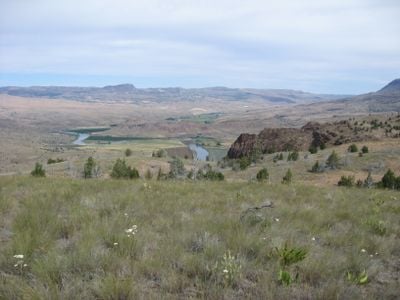
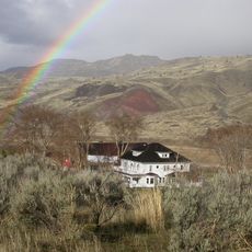
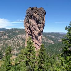
Spring Basin Wilderness, Nature reserve near Clarno, Oregon.

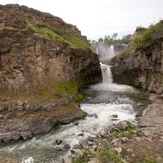
Spring Basin Wilderness is a protected area spread across rolling hills, cliffs, and remote canyons linked to the John Day River. The terrain is mostly open and exposed, with few marked trails and only one main water source located in the interior.

Congress established this wilderness through federal legislation in 2009 that protected thousands of acres across western states. This legal designation made it a permanent protected area with strict rules against development.

Native bunchgrasses, western juniper, and sagebrush dominate the landscape here, reflecting the natural character of the Pacific Northwest region. These plants shape how the land looks and feels throughout the seasons.

Bring paper maps and carry sufficient water supplies, as trails here are barely marked and navigation requires some experience. Planning your route ahead of time helps you avoid getting lost in the remote terrain.

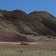
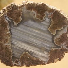
Rock formations here hold fossils from a time when subtropical forest covered the land and small four-toed horses roamed among palm and magnolia trees. These traces from millions of years ago remain visible beneath the dry landscape of today.

Location: Oregon

Inception: 2009

GPS coordinates: 44.90000,-120.40000

Latest update: December 13, 2025 11:41

Photos
Around this place
Painted Hills
United States of America

Painted Hills

28.4 km
White River Falls State Park
United States of America

White River Falls State Park

66.6 km
Cottonwood Canyon State Park
United States of America

Cottonwood Canyon State Park

64.6 km
Pelton Dam
United States of America

Pelton Dam

69.5 km
Bridge Creek Wilderness
United States of America

Bridge Creek Wilderness

49.3 km
James Cant Ranch
United States of America

James Cant Ranch

71 km
Mill Creek Wilderness
United States of America

Mill Creek Wilderness

48.1 km
United States of America

Boxcar Rapids

62.5 km
Dyer State Wayside
United States of America

Dyer State Wayside

30.1 km
Shaniko Hotel
United States of America

Shaniko Hotel

30.1 km
The Museum at Warm Springs
United States of America

The Museum at Warm Springs

68.9 km
Grizzly Mountain
United States of America

Grizzly Mountain

67.7 km
Crook County Courthouse
United States of America

Crook County Courthouse

75.3 km
Imperial Stock Ranch Headquarters Complex
United States of America

Imperial Stock Ranch Headquarters Complex

37.8 km
A. R. Bowman Memorial Museum
United States of America

A. R. Bowman Memorial Museum

75.3 km
Maupin Section Foreman's House
United States of America

Maupin Section Foreman's House

61.5 km
John and Helen Moore House
United States of America

John and Helen Moore House

66.8 km
Thomas Benton Hoover House
United States of America

Thomas Benton Hoover House

18.4 km
S. B. Barker Building
United States of America

S. B. Barker Building

40.9 km
Crook County Bank Building
United States of America

Crook County Bank Building

75.3 km
Fossil Public School
United States of America

Fossil Public School

18.5 km
Silas A. Rice Log House
United States of America

Silas A. Rice Log House

41.8 km
Lamonta Compound
United States of America

Lamonta Compound

74.8 km
Max and Ollie Lueddemann House
United States of America

Max and Ollie Lueddemann House

64.4 km
Thomas Condon Paleontology Center
United States of America

Thomas Condon Paleontology Center

71 km
Sherman County Courthouse
United States of America

Sherman County Courthouse

62.1 km
Shaniko Historic District
United States of America

Shaniko Historic District

30.1 km
Stein's Pillar
United States of America

Stein's Pillar

57.1 km
Show the full map
Reviews

Visited this place? Tap the stars to rate it and share your experience / photos with the community! Try now! You can cancel it anytime.

« Spring Basin Wilderness - Nature reserve near Clarno, Oregon » is provided by Around Us (aroundus.com). Images and texts are derived from Wikimedia project under a Creative Commons license. You are allowed to copy, distribute, and modify copies of this page, under the conditions set by the license, as long as this note is clearly visible.

Discover hidden gems everywhere you go!

From secret cafés to breathtaking viewpoints, skip the crowded tourist spots and find places that match your style. Our app makes it easy with voice search, smart filtering, route optimization, and insider tips from travelers worldwide. Download now for the complete mobile experience.

Around Us App Screenshot

A unique approach to discovering new places

Le Figaro

All the places worth exploring

France Info

A tailor-made excursion in just a few clicks

20 Minutes