Enable Location

We need your location to show you interesting places around you

Discover nearby places

Find interesting locations and hidden gems around you

Precise directions

Get accurate directions and distances to places

Your location is never shared with other users. It's only used when you tap the location button.

Stein's Pillar

Log in to your account

Start exploring — it's free

Trusted by 61,494 travelers worldwide

Continue with Google
Continue with Apple
or

We will send you a code to connect

By continuing, you accept our Terms and Conditions and our Privacy Policy

Check your inbox

We've sent a pincode in your inbox. Please enter the code below.

Stein's Pillar

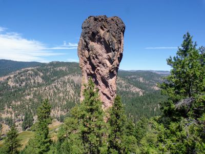
Stein's Pillar, Natural summit in Crook County, Oregon, US

Description

Stein's Pillar is a towering rock spire made of welded tuff near Prineville in Oregon. It rises sharply from the surrounding terrain and displays the geological layers that tell the story of millions of years of Earth history.

History

The formation originated about 40 million years ago when a volcanic caldera collapsed and deposited ash. This ash solidified over time into a compact structure that created the present-day rock pillar.

Culture

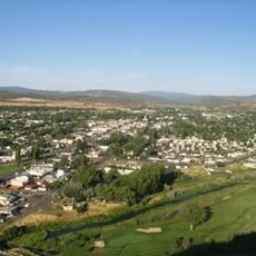
The surrounding area serves as an educational resource for local schools and geological studies, contributing to community learning initiatives.

Practical

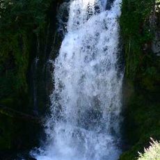
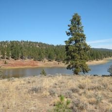
The trail to the pillar is well marked and passes through forests and meadows, with the round trip taking about two hours. The terrain is somewhat hilly, so visitors should wear sturdy shoes and bring plenty of water.

Did you know?

The trail passes through old growth forest and mountain meadows before reaching the base of the geological formation.

Location
Address
Steins Pillar, Oregon 97754, USA
GPS coordinates
44.41184,-120.61957
Latest update
December 15, 2025 13:21

AroundUs brings together thousands of curated places, local tips, and hidden gems, enriched daily by 60,000 contributors worldwide. Discover all places nearby (Crook County).

Around this place
Smith Rock State Park
United States of America

Smith Rock State Park

41.5 km
Painted Hills
United States of America

Painted Hills

39.1 km
Cline Falls State Scenic Viewpoint
United States of America

Cline Falls State Scenic Viewpoint

53.1 km
Crooked River High Bridge
United States of America

Crooked River High Bridge

45.7 km
Peter Skene Ogden State Scenic Viewpoint
United States of America

Peter Skene Ogden State Scenic Viewpoint

45.7 km
Crooked River Railroad Bridge
United States of America

Crooked River Railroad Bridge

45.9 km
Crooked River Gorge
United States of America

Crooked River Gorge

48.6 km
Bridge Creek Wilderness
United States of America

Bridge Creek Wilderness

32.2 km
Mill Creek Wilderness
United States of America

Mill Creek Wilderness

10.4 km
Rex T. Barber Veterans Memorial Bridge
United States of America

Rex T. Barber Veterans Memorial Bridge

45.7 km
Redmond–Bend Juniper State Scenic Corridor
United States of America

Redmond–Bend Juniper State Scenic Corridor

55.6 km
Ochoco State Scenic Viewpoint
United States of America

Ochoco State Scenic Viewpoint

23.5 km
Prineville Reservoir Wildlife Area
United States of America

Prineville Reservoir Wildlife Area

31.6 km
Milton Odem House
United States of America

Milton Odem House

47.4 km
Roba Ranch
United States of America

Roba Ranch

53.3 km
First Presbyterian Church of Redmond
United States of America

First Presbyterian Church of Redmond

46.8 km
Grizzly Mountain
United States of America

Grizzly Mountain

26.9 km
Crook County Courthouse
United States of America

Crook County Courthouse

21.6 km
Antelope Flat Reservoir
United States of America

Antelope Flat Reservoir

48.8 km
A. R. Bowman Memorial Museum
United States of America

A. R. Bowman Memorial Museum

21.8 km
Thomas M. Baldwin House
United States of America

Thomas M. Baldwin House

22 km
Old First National Bank of Prineville
United States of America

Old First National Bank of Prineville

21.8 km
Crook County Bank Building
United States of America

Crook County Bank Building

21.8 km
Marion Reed Elliott House
United States of America

Marion Reed Elliott House

21.9 km
Lamonta Compound
United States of America

Lamonta Compound

21.7 km
Max and Ollie Lueddemann House
United States of America

Max and Ollie Lueddemann House

47.2 km
Pine Theater
United States of America

Pine Theater

21.8 km
Pilot Butte Canal Downtown Redmond Segment
United States of America

Pilot Butte Canal Downtown Redmond Segment

45.8 km
Show the full map
« Stein's Pillar - Natural summit in Crook County, Oregon, US » is provided by Around Us (aroundus.com). Images and texts are derived from Wikimedia project under a Creative Commons license. You are allowed to copy, distribute, and modify copies of this page, under the conditions set by the license, as long as this note is clearly visible.

Discover hidden gems everywhere you go!

From secret cafés to breathtaking viewpoints, skip the crowded tourist spots and find places that match your style. Our app makes it easy with voice search, smart filtering, route optimization, and insider tips from travelers worldwide. Download now for the complete mobile experience.

Around Us App Screenshot

A unique approach to discovering new places

Le Figaro

All the places worth exploring

France Info

A tailor-made excursion in just a few clicks

20 Minutes

Around Us
Travel Guide & Maps
Download

Send to your phone

QR Code
1

Open the camera app on your mobile.

2

Point at the QR code with your camera. A notification will appear.

3

Tap the notification to open the link.