Ochoco State Scenic Viewpoint

Log in to your account

AroundUs is a community-driven map of interesting places, built by curious explorers like you. It grows with every review, story, and photo you share.
Connect to save your favorite spots, contribute locations, and create personalized routes.
Continue with Google
Continue with Apple
Continue with X
Continue with Facebook
Continue with email
By continuing, you accept our Terms and Conditions and our Privacy Policy
Create an account

Ochoco State Scenic Viewpoint

Add to collection
Map
Suggest a change
Share

Ochoco State Scenic Viewpoint, State park observation point in Crook County, Oregon, United States

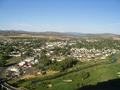
Ochoco State Scenic Viewpoint is an observation point in Crook County that overlooks the Prineville Valley and surrounding mountain ranges. From this elevated position, visitors see the Cascade Range peaks, the Blue Mountains, and the forested landscape of the Ochoco National Forest spreading across the horizon.

A fire lookout tower stood at this location in the 1930s to spot wildfires across Central Oregon's forests. The site later became a public viewpoint integrated into Oregon's network of state parks for visitor access.

The viewpoint sits within Oregon's state park network, designed to invite visitors to experience and appreciate the region's natural landscape. People come to this spot to connect with the surrounding wilderness and take in the expansive valley and mountain scenery.

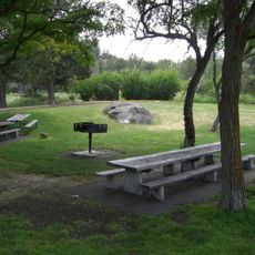
The site offers picnic areas, restroom facilities, and parking spaces available year-round for visitors. Roads can be snow-covered in winter months, so it is best visited during spring through fall when conditions are clearer and easier to navigate.

The elevation provides a rare vantage point where two major mountain ranges are visible from a single location. This makes it a valuable spot for understanding how the surrounding terrain connects and changes across the region.

Location: Oregon

GPS coordinates: 44.29980,-120.87000

Latest update: December 13, 2025 17:03

Photos
Around this place
Smith Rock State Park
United States of America

Smith Rock State Park

22.7 km
Petersen Rock Garden
United States of America

Petersen Rock Garden

33.1 km
Oregon Badlands Wilderness
United States of America

Oregon Badlands Wilderness

36 km
Tumalo State Park
United States of America

Tumalo State Park

41.6 km
Cline Falls State Scenic Viewpoint
United States of America

Cline Falls State Scenic Viewpoint

31 km
Crooked River High Bridge
United States of America

Crooked River High Bridge

27.8 km
Peter Skene Ogden State Scenic Viewpoint
United States of America

Peter Skene Ogden State Scenic Viewpoint

27.7 km
Crooked River Railroad Bridge
United States of America

Crooked River Railroad Bridge

27.9 km
Crooked River Gorge
United States of America

Crooked River Gorge

31.5 km
Mill Creek Wilderness
United States of America

Mill Creek Wilderness

33.8 km
Rex T. Barber Veterans Memorial Bridge
United States of America

Rex T. Barber Veterans Memorial Bridge

27.7 km
Redmond–Bend Juniper State Scenic Corridor
United States of America

Redmond–Bend Juniper State Scenic Corridor

32.3 km
Prineville Reservoir Wildlife Area
United States of America

Prineville Reservoir Wildlife Area

20.1 km
Milton Odem House
United States of America

Milton Odem House

25 km
New Redmond Hotel
United States of America

New Redmond Hotel

24.5 km
First Presbyterian Church of Redmond
United States of America

First Presbyterian Church of Redmond

24.5 km
Grizzly Mountain
United States of America

Grizzly Mountain

16.8 km
Charles Boyd Homestead Group
United States of America

Charles Boyd Homestead Group

42.1 km
Crook County Courthouse
United States of America

Crook County Courthouse

2.1 km
A. R. Bowman Memorial Museum
United States of America

A. R. Bowman Memorial Museum

1.9 km
Rock O' the Range Bridge
United States of America

Rock O' the Range Bridge

38.5 km
Thomas M. Baldwin House
United States of America

Thomas M. Baldwin House

1.8 km
Old First National Bank of Prineville
United States of America

Old First National Bank of Prineville

1.8 km
Crook County Bank Building
United States of America

Crook County Bank Building

1.9 km
Marion Reed Elliott House
United States of America

Marion Reed Elliott House

1.8 km
Lamonta Compound
United States of America

Lamonta Compound

1.8 km
Pine Theater
United States of America

Pine Theater

1.8 km
Pilot Butte Canal Downtown Redmond Segment
United States of America

Pilot Butte Canal Downtown Redmond Segment

23.8 km
Show the full map
Reviews

Visited this place? Tap the stars to rate it and share your experience / photos with the community! Try now! You can cancel it anytime.

« Ochoco State Scenic Viewpoint - State park observation point in Crook County, Oregon, United States » is provided by Around Us (aroundus.com). Images and texts are derived from Wikimedia project under a Creative Commons license. You are allowed to copy, distribute, and modify copies of this page, under the conditions set by the license, as long as this note is clearly visible.

Discover hidden gems everywhere you go!

From secret cafés to breathtaking viewpoints, skip the crowded tourist spots and find places that match your style. Our app makes it easy with voice search, smart filtering, route optimization, and insider tips from travelers worldwide. Download now for the complete mobile experience.

Around Us App Screenshot

A unique approach to discovering new places

Le Figaro

All the places worth exploring

France Info

A tailor-made excursion in just a few clicks

20 Minutes