Enable Location

We need your location to show you interesting places around you

Discover nearby places

Find interesting locations and hidden gems around you

Precise directions

Get accurate directions and distances to places

Your location is never shared with other users. It's only used when you tap the location button.

Painted Hills

Log in to your account

Start exploring — it's free

Trusted by 61,905 travelers worldwide

Continue with Google
Continue with Apple
or

We will send you a code to connect

By continuing, you accept our Terms and Conditions and our Privacy Policy

Check your inbox

We've sent a pincode in your inbox. Please enter the code below.

Painted Hills

Painted Hills, Protected area in Wheeler County, Oregon.

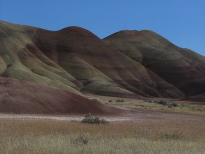
Painted Hills are part of the John Day Fossil Beds National Monument and show bands of red, beige and orange sediment stretching across several elevations. The colors appear in horizontal and wavy stripes on the surface of the hills, which are made of weathered volcanic rock.

The deposits formed around 35 million years ago when eruptions from the Cascade Range carried ash and pumice eastward. The layers preserved remains of plants and animals that lived in a wetter climate.

The name refers to the colorful claystone layers that look like brushstrokes on the rounded hills. Visitors follow wooden boardwalks to different viewing points where they can observe the folds and colors.

The trails are short and lead on paved or raised boardwalks to different points along the edge of the colored areas. Late afternoon offers the best light to see the contrasts between the colors.

Moisture in the soil changes the intensity of the mineral colors depending on the season, so the same spot looks lighter in spring and darker in autumn. Black basalt layers occasionally run through the reddish hills and mark younger lava flows.

The community of curious travelers

AroundUs brings together thousands of curated places, local tips, and hidden gems, enriched daily by 60,000 contributors worldwide.

Start exploring
Location
Location
GPS coordinates
44.66139,-120.27306
Latest update
December 17, 2025 10:52
Around this place
Bridge Creek Wilderness
United States of America

Bridge Creek Wilderness

21.1 km
James Cant Ranch
United States of America

James Cant Ranch

51.1 km
Black Canyon Wilderness
United States of America

Black Canyon Wilderness

61 km
Mill Creek Wilderness
United States of America

Mill Creek Wilderness

28.7 km
Spring Basin Wilderness
United States of America

Spring Basin Wilderness

28.4 km
Dyer State Wayside
United States of America

Dyer State Wayside

52 km
Ochoco State Scenic Viewpoint
United States of America

Ochoco State Scenic Viewpoint

62.2 km
Shaniko Hotel
United States of America

Shaniko Hotel

53.7 km
Prineville Reservoir Wildlife Area
United States of America

Prineville Reservoir Wildlife Area

68.9 km
Roba Ranch
United States of America

Roba Ranch

53 km
Grizzly Mountain
United States of America

Grizzly Mountain

59.6 km
Crook County Courthouse
United States of America

Crook County Courthouse

60.4 km
Imperial Stock Ranch Headquarters Complex
United States of America

Imperial Stock Ranch Headquarters Complex

63.4 km
Antelope Flat Reservoir
United States of America

Antelope Flat Reservoir

73.7 km
A. R. Bowman Memorial Museum
United States of America

A. R. Bowman Memorial Museum

60.6 km
Thomas M. Baldwin House
United States of America

Thomas M. Baldwin House

60.8 km
Thomas Benton Hoover House
United States of America

Thomas Benton Hoover House

37.9 km
Old First National Bank of Prineville
United States of America

Old First National Bank of Prineville

60.6 km
S. B. Barker Building
United States of America

S. B. Barker Building

64.2 km
Crook County Bank Building
United States of America

Crook County Bank Building

60.6 km
Fossil Public School
United States of America

Fossil Public School

38 km
Marion Reed Elliott House
United States of America

Marion Reed Elliott House

60.8 km
Silas A. Rice Log House
United States of America

Silas A. Rice Log House

65 km
Lamonta Compound
United States of America

Lamonta Compound

60.4 km
Max and Ollie Lueddemann House
United States of America

Max and Ollie Lueddemann House

67.5 km
Thomas Condon Paleontology Center
United States of America

Thomas Condon Paleontology Center

51.1 km
Pine Theater
United States of America

Pine Theater

60.6 km
Shaniko Historic District
United States of America

Shaniko Historic District

53.7 km
Show the full map
« Painted Hills - Protected area in Wheeler County, Oregon » is provided by Around Us (aroundus.com). Images and texts are derived from Wikimedia project under a Creative Commons license. You are allowed to copy, distribute, and modify copies of this page, under the conditions set by the license, as long as this note is clearly visible.

Discover hidden gems everywhere you go!

From secret cafés to breathtaking viewpoints, skip the crowded tourist spots and find places that match your style. Our app makes it easy with voice search, smart filtering, route optimization, and insider tips from travelers worldwide. Download now for the complete mobile experience.

Around Us App Screenshot

A unique approach to discovering new places

Le Figaro

All the places worth exploring

France Info

A tailor-made excursion in just a few clicks

20 Minutes

Around Us
Travel Guide & Maps
Download

Send to your phone

QR Code
1

Open the camera app on your mobile.

2

Point at the QR code with your camera. A notification will appear.

3

Tap the notification to open the link.