Enable Location

We need your location to show you interesting places around you

Discover nearby places

Find interesting locations and hidden gems around you

Precise directions

Get accurate directions and distances to places

Your location is never shared with other users. It's only used when you tap the location button.

Log in to your account

Start exploring — it's free

Trusted by 63,917 travelers worldwide

Continue with Google
Continue with Apple
or

We will send you a code to connect

By continuing, you accept our Terms and Conditions and our Privacy Policy

Check your inbox

We've sent a pincode in your inbox. Please enter the code below.

Reed Island State Park
Discussion Reviews Photo
2.2k Popularity

Reed Island State Park, State park on Columbia River, Washington.

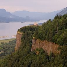
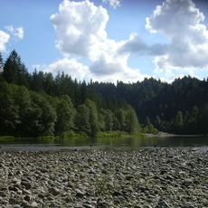
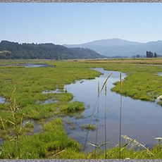
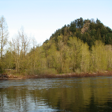
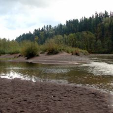
Reed Island State Park spans about 427 acres with sandy beaches, meadows, and riverside forests along the Columbia River, with no road access or permanent structures. The landscape features natural shorelines and floodplain forests where visitors can explore and observe wildlife.

Washington State Parks and Recreation Commission established this protected area to preserve the natural habitat of local wildlife. The park developed as a recreational zone along the river to support nature-based activities.

The park connects to the Columbia River Water Trail system, which follows traditional waterways for recreation and exploration. Visitors experience the river as a corridor for movement and connection, mirroring how people historically used these waters.

Visitors must bring their own boats since the island has no road access and lacks restrooms or drinking water. Planning ahead and bringing all necessary supplies for a boat-based visit are essential.

The southwestern section of the island contains an active heron colony where these water birds can be observed in their natural setting. This bird colony is a feature that often surprises visitors as they explore the park.

The community of curious travelers

AroundUs brings together thousands of curated places, local tips, and hidden gems, enriched daily by 60,000 contributors worldwide.

Start exploring
Location
GPS coordinates
45.55190,-122.30400
Latest update
December 13, 2025 17:08
Around this place
Historic Columbia River Highway
United States of America

Historic Columbia River Highway

5.9 km
Vista House
United States of America

Vista House

4.9 km
Rooster Rock State Park
United States of America

Rooster Rock State Park

5.4 km
Crown Point
United States of America

Crown Point

4.9 km
Latourell Falls
United States of America

Latourell Falls

6.9 km
Oxbow Regional Park
United States of America

Oxbow Regional Park

6.4 km
Bridal Veil Falls
United States of America

Bridal Veil Falls

9.7 km
United States of America

Chanticleer Point

3.3 km
Steigerwald Lake National Wildlife Refuge
United States of America

Steigerwald Lake National Wildlife Refuge

1.5 km
Guy W. Talbot State Park
United States of America

Guy W. Talbot State Park

6.4 km
Lewis and Clark State Recreation Site
United States of America

Lewis and Clark State Recreation Site

5.8 km
Dabney State Recreation Area
United States of America

Dabney State Recreation Area

5.5 km
Liberty Theatre
United States of America

Liberty Theatre

8.7 km
George W. Joseph State Natural Area
United States of America

George W. Joseph State Natural Area

6.9 km
Stark Street Bridge
United States of America

Stark Street Bridge

6 km
Farrell Building
United States of America

Farrell Building

8.8 km
John Roffler House
United States of America

John Roffler House

8.9 km
Springdale School
United States of America

Springdale School

4.1 km
Andreas Graf House
United States of America

Andreas Graf House

8.8 km
Troutdale Methodist Episcopal Church
United States of America

Troutdale Methodist Episcopal Church

6.6 km
Fred Harlow House
United States of America

Fred Harlow House

6.3 km
Troutdale Library
United States of America

Troutdale Library

8.6 km
Fairview City Jail
United States of America

Fairview City Jail

10.2 km
Troutdale Sandy River Bridge
United States of America

Troutdale Sandy River Bridge

5.9 km
Sunrise Park
United States of America

Sunrise Park

7.5 km
Camas Public Library
United States of America

Camas Public Library

8.6 km
Pillars of Hercules
United States of America

Pillars of Hercules

9 km
Rooster Rock
United States of America

Rooster Rock

4.3 km
Show the full map
Reviews
Share your experience

No review yet

Discussions
Start a discussion...

No discussion yet

« Reed Island State Park - State park on Columbia River, Washington » is provided by Around Us (aroundus.com). Images and texts are derived from Wikimedia project under a Creative Commons license. You are allowed to copy, distribute, and modify copies of this page, under the conditions set by the license, as long as this note is clearly visible.

Discover hidden gems everywhere you go!

From secret cafés to breathtaking viewpoints, skip the crowded tourist spots and find places that match your style. Our app makes it easy with voice search, smart filtering, route optimization, and insider tips from travelers worldwide. Download now for the complete mobile experience.

Around Us App Screenshot

A unique approach to discovering new places

Le Figaro

All the places worth exploring

France Info

A tailor-made excursion in just a few clicks

20 Minutes

Around Us
Travel Guide & Maps
Download

Send to your phone

QR Code
1

Open the camera app on your mobile.

2

Point at the QR code with your camera. A notification will appear.

3

Tap the notification to open the link.