Enable Location

We need your location to show you interesting places around you

Discover nearby places

Find interesting locations and hidden gems around you

Precise directions

Get accurate directions and distances to places

Your location is never shared with other users. It's only used when you tap the location button.

Bridal Veil Falls

Log in to your account

Start exploring — it's free

Trusted by 66,055 travelers worldwide

Continue with Google
Continue with Apple
or

We will send you a code to connect

By continuing, you accept our Terms and Conditions and our Privacy Policy

Check your inbox

We've sent a pincode in your inbox. Please enter the code below.

Bridal Veil Falls
Discussion Reviews 1 Photos
6.1k Popularity

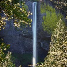
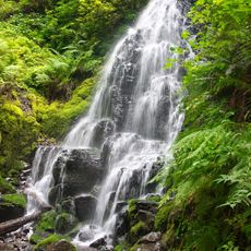
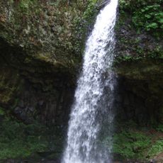
Bridal Veil Falls, Waterfall in Yosemite Valley, US

Bridal Veil Falls is a waterfall in Yosemite Valley, California, dropping straight down a vertical granite cliff at the valley's western end. A paved trail leads visitors to a viewpoint close to the base, where the spray can be felt on calm days.

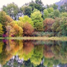
Glaciers carved out Yosemite Valley during the last ice age, leaving behind the steep cliffs that make waterfalls like this one possible. The name Bridal Veil Falls was given by the first group of non-Native Americans to enter the valley, in 1851.

The Ahwahneechee people, who originally lived in the valley, called this waterfall "Pohono", meaning the spirit of the wind. That name still makes sense today: on windy days, the water is pushed sideways by gusts before it ever reaches the ground below.

The waterfall flows strongest in spring, when snowmelt feeds it from above, though it runs year-round. A short paved trail from a nearby parking area leads directly to a viewpoint close to the base, so no strenuous walking is needed.

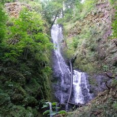
By late summer, the flow can shrink to almost nothing in dry years, leaving only a thin trace of water on the rock face. This means that visitors who come in summer hoping for a full waterfall may find something far less dramatic than expected.

The community of curious travelers

AroundUs brings together thousands of curated places, local tips, and hidden gems, enriched daily by 60,000 contributors worldwide.

Start exploring
GPS coordinates
45.55496,-122.18023
Latest update
March 3, 2026 22:40
Around this place
Multnomah Falls
United States of America

Multnomah Falls

5.6 km
Vista House
United States of America

Vista House

5.2 km
Rooster Rock State Park
United States of America

Rooster Rock State Park

4.5 km
Oneonta Gorge
United States of America

Oneonta Gorge

9 km
Crown Point
United States of America

Crown Point

5.3 km
Latourell Falls
United States of America

Latourell Falls

3.6 km
Larch Mountain
United States of America

Larch Mountain

7.5 km
Horsetail Falls
United States of America

Horsetail Falls

9.5 km
Oxbow Regional Park
United States of America

Oxbow Regional Park

10.7 km
Wahkeena Falls
United States of America

Wahkeena Falls

4.7 km
United States of America

Chanticleer Point

7 km
Fairy Falls
United States of America

Fairy Falls

4.7 km
Steigerwald Lake National Wildlife Refuge
United States of America

Steigerwald Lake National Wildlife Refuge

9.7 km
Ainsworth State Park
United States of America

Ainsworth State Park

10.5 km
Guy W. Talbot State Park
United States of America

Guy W. Talbot State Park

4.1 km
Camp Namanu
United States of America

Camp Namanu

12.9 km
Dabney State Recreation Area
United States of America

Dabney State Recreation Area

14.1 km
Franz Lake National Wildlife Refuge
United States of America

Franz Lake National Wildlife Refuge

9.7 km
Benson State Recreation Area
United States of America

Benson State Recreation Area

5 km
George W. Joseph State Natural Area
United States of America

George W. Joseph State Natural Area

4.2 km
Coopey Falls
United States of America

Coopey Falls

1.4 km
Springdale School
United States of America

Springdale School

12.3 km
Andreas Graf House
United States of America

Andreas Graf House

5.4 km
Lusted Road Bridge
United States of America

Lusted Road Bridge

13.5 km
Multnomah Falls Lodge and Footpath
United States of America

Multnomah Falls Lodge and Footpath

5.6 km
Horsetail Falls Developed Area Masonry Walls and Kiosk
United States of America

Horsetail Falls Developed Area Masonry Walls and Kiosk

9.5 km
Pillars of Hercules
United States of America

Pillars of Hercules

710 m
Rooster Rock
United States of America

Rooster Rock

5.6 km
Show the full map
Reviews
Share your experience

No review yet

Discussions
Start a discussion...

No discussion yet

« Bridal Veil Falls - Waterfall in Yosemite Valley, US » is provided by Around Us (aroundus.com). Images and texts are derived from Wikimedia project under a Creative Commons license. You are allowed to copy, distribute, and modify copies of this page, under the conditions set by the license, as long as this note is clearly visible.

Discover hidden gems everywhere you go!

From secret cafés to breathtaking viewpoints, skip the crowded tourist spots and find places that match your style. Our app makes it easy with voice search, smart filtering, route optimization, and insider tips from travelers worldwide. Download now for the complete mobile experience.

Around Us App Screenshot

A unique approach to discovering new places

Le Figaro

All the places worth exploring

France Info

A tailor-made excursion in just a few clicks

20 Minutes

Around Us
Travel Guide & Maps
Download

Send to your phone

QR Code
1

Open the camera app on your mobile.

2

Point at the QR code with your camera. A notification will appear.

3

Tap the notification to open the link.