Enable Location

We need your location to show you interesting places around you

Discover nearby places

Find interesting locations and hidden gems around you

Precise directions

Get accurate directions and distances to places

Your location is never shared with other users. It's only used when you tap the location button.

River Mill Hydroelectric Project

Log in to your account

Start exploring — it's free

Trusted by 62,331 travelers worldwide

Continue with Google
Continue with Apple
or

We will send you a code to connect

By continuing, you accept our Terms and Conditions and our Privacy Policy

Check your inbox

We've sent a pincode in your inbox. Please enter the code below.

River Mill Hydroelectric Project, hydroelectric dam and powerhouse in Clackamas County, Oregon, United States

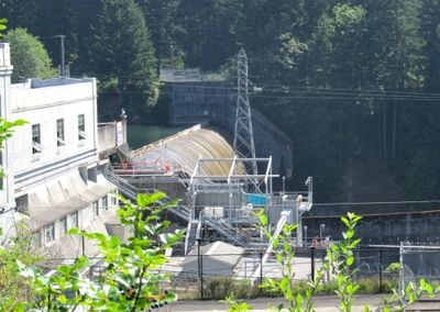
The River Mill Hydroelectric Project is a dam and power station on the Clackamas River in Oregon that has been generating electricity for over a century. The structure was completed in 1911 and uses a special Ambursen design with concrete elements that support one another.

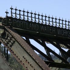
The power station was built in 1911 by Portland Railway, Light and Power Company and was one of the first major hydroelectric projects in Oregon. The Ambursen design was innovative for its time and helped establish new standards for concrete dam construction.

The dam bears the name of its designer Nils F. Ambursen and is seen by locals as a landmark of their energy development. For the community, the structure represents a chapter in regional industrial growth and remains an active part of daily infrastructure.

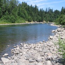
The power station can be viewed from the east bank of the river and offers quiet paths for walking nearby. The best visits are on peaceful days when you can enjoy the sounds of flowing water and nature without distraction.

The structure is one of only three Ambursen dams on the west side of the Mississippi River and showcases a revolutionary concrete technique. This rare design feature makes it an important example of engineering history that influenced dam construction worldwide.

The community of curious travelers

AroundUs brings together thousands of curated places, local tips, and hidden gems, enriched daily by 60,000 contributors worldwide.

Start exploring
Location
Location
GPS coordinates
45.29990,-122.35000
Latest update
February 9, 2026 08:20
Around this place
Willamette Meteorite
United States of America

Willamette Meteorite

19.7 km
Boring Lava Field
United States of America

Boring Lava Field

11.7 km
Milo McIver State Park
United States of America

Milo McIver State Park

1.9 km
Abernethy Bridge
United States of America

Abernethy Bridge

21.1 km
Parents of Murdered Children Memorial
United States of America

Parents of Murdered Children Memorial

19.5 km
Camp Namanu
United States of America

Camp Namanu

18.5 km
Francis Ermatinger House
United States of America

Francis Ermatinger House

20.9 km
Philip Foster Farm
United States of America

Philip Foster Farm

6.6 km
United States of America

North Fork Reservoir

9.9 km
Bonnie Lure State Recreation Area
United States of America

Bonnie Lure State Recreation Area

6.2 km
Oregon Military Museum
United States of America

Oregon Military Museum

20.5 km
Capt. John C. Ainsworth House
United States of America

Capt. John C. Ainsworth House

20.1 km
Horace Baker Log Cabin
United States of America

Horace Baker Log Cabin

8.4 km
Haggart Observatory
United States of America

Haggart Observatory

18 km
Morton Matthew McCarver House
United States of America

Morton Matthew McCarver House

20.7 km
Harvey Cross House
United States of America

Harvey Cross House

20.9 km
William L. Holmes House
United States of America

William L. Holmes House

20.1 km
R. S. Smith Motor Company Building
United States of America

R. S. Smith Motor Company Building

12.8 km
Oregon City Public Library
United States of America

Oregon City Public Library

20.8 km
Lusted Road Bridge
United States of America

Lusted Road Bridge

17.8 km
Moontrap (Kelly)
United States of America

Moontrap (Kelly)

21.1 km
Damascus School
United States of America

Damascus School

15.5 km
North American Bigfoot Center
United States of America

North American Bigfoot Center

14.7 km
Barclay House
United States of America

Barclay House

21 km
David and Marianne Ott House
United States of America

David and Marianne Ott House

20.8 km
McLoughlin House
United States of America

McLoughlin House

21 km
McLoughlin Promenade Grand Staircase
United States of America

McLoughlin Promenade Grand Staircase

21.1 km
Mount Hood National Forest Headquarters
United States of America

Mount Hood National Forest Headquarters

12.5 km
Show the full map
« River Mill Hydroelectric Project - hydroelectric dam and powerhouse in Clackamas County, Oregon, United States » is provided by Around Us (aroundus.com). Images and texts are derived from Wikimedia project under a Creative Commons license. You are allowed to copy, distribute, and modify copies of this page, under the conditions set by the license, as long as this note is clearly visible.

Discover hidden gems everywhere you go!

From secret cafés to breathtaking viewpoints, skip the crowded tourist spots and find places that match your style. Our app makes it easy with voice search, smart filtering, route optimization, and insider tips from travelers worldwide. Download now for the complete mobile experience.

Around Us App Screenshot

A unique approach to discovering new places

Le Figaro

All the places worth exploring

France Info

A tailor-made excursion in just a few clicks

20 Minutes

Around Us
Travel Guide & Maps
Download

Send to your phone

QR Code
1

Open the camera app on your mobile.

2

Point at the QR code with your camera. A notification will appear.

3

Tap the notification to open the link.