Enable Location

We need your location to show you interesting places around you

Discover nearby places

Find interesting locations and hidden gems around you

Precise directions

Get accurate directions and distances to places

Your location is never shared with other users. It's only used when you tap the location button.

Deschutes River State Recreation Area

Log in to your account

Start exploring — it's free

Trusted by 64,876 travelers worldwide

Continue with Google
Continue with Apple
or

We will send you a code to connect

By continuing, you accept our Terms and Conditions and our Privacy Policy

Check your inbox

We've sent a pincode in your inbox. Please enter the code below.

Deschutes River State Recreation Area
Discussion Reviews 1 Photos
3k Popularity

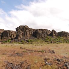
Deschutes River State Recreation Area, State recreation area at river confluence in The Dalles, Oregon.

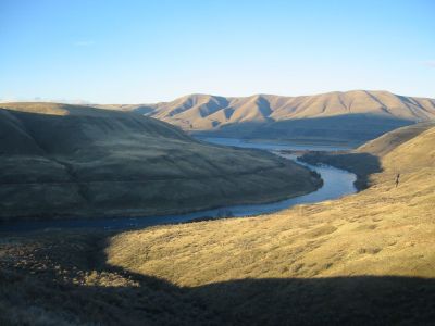
Deschutes River State Recreation Area is an Oregon state park located at the point where the Deschutes River meets the Columbia River, near The Dalles. The park includes camping areas, fishing access along the riverbanks, and walking paths through the wooded land beside the water.

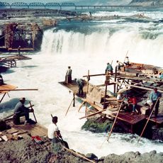
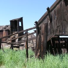
The park began to take shape in 1955 after the local Chamber of Commerce pushed for the land to be acquired for public use, with the process completing in 1963. Before that, the confluence had been a working area connected to river travel and trade along the Columbia.

The area around the river confluence has long been a gathering place for the Warm Springs and Wasco peoples, who have fished these waters for generations. Visitors walking along the banks today can still see people fishing here in ways that reflect this long connection to the river.

The park is open year-round, though spring and early fall tend to offer the most comfortable conditions for spending time by the river. Camping options range from sites with water and electrical connections to simpler tent spots, and shower facilities are available on site.

An active rail line runs right along the edge of the campground, and trains pass close enough that you can hear and feel them from your tent or campsite. This is not something most people expect when they arrive, and it gives the place a very different feel from a typical riverside park.

The community of curious travelers

AroundUs brings together thousands of curated places, local tips, and hidden gems, enriched daily by 60,000 contributors worldwide.

Start exploring
Location
GPS coordinates
45.63350,-120.91000
Latest update
March 3, 2026 13:52
Around this place
Maryhill Stonehenge
United States of America

Maryhill Stonehenge

10.5 km
Celilo Falls
United States of America

Celilo Falls

5.6 km
John Day Dam
United States of America

John Day Dam

19.2 km
Pacific DC Intertie
United States of America

Pacific DC Intertie

16.5 km
The Dalles Dam
United States of America

The Dalles Dam

17.5 km
Maryhill Museum of Art
United States of America

Maryhill Museum of Art

6 km
Celilo Converter Station
United States of America

Celilo Converter Station

16.4 km
Sam Hill Memorial Bridge
United States of America

Sam Hill Memorial Bridge

7.5 km
The Dalles Bridge
United States of America

The Dalles Bridge

18 km
The Dalles Mint
United States of America

The Dalles Mint

21.2 km
Maryhill State Park
United States of America

Maryhill State Park

8.5 km
Oregon Trunk Rail Bridge
United States of America

Oregon Trunk Rail Bridge

5.9 km
Columbia Hills Historical State Park
United States of America

Columbia Hills Historical State Park

15.2 km
Charles E. Nelson House
United States of America

Charles E. Nelson House

13.5 km
Columbia Hills
United States of America

Columbia Hills

15.3 km
Granada Theater
United States of America

Granada Theater

21.5 km
Dr. J. A. Reuter House
United States of America

Dr. J. A. Reuter House

21.6 km
Indian Shaker Church and Gulick Homestead
United States of America

Indian Shaker Church and Gulick Homestead

17.6 km
The Dalles Civic Auditorium
United States of America

The Dalles Civic Auditorium

21.5 km
First Day Advent Christian Church
United States of America

First Day Advent Christian Church

9.6 km
The Dalles Carnegie Library
United States of America

The Dalles Carnegie Library

21.6 km
Joseph D. and Margaret Kelly House
United States of America

Joseph D. and Margaret Kelly House

21.3 km
U.S. Post Office
United States of America

U.S. Post Office

21.7 km
John and Murta Van Dellen House
United States of America

John and Murta Van Dellen House

21.7 km
Sharp Family Residential Ensemble
United States of America

Sharp Family Residential Ensemble

21.4 km
Fulton–Taylor House
United States of America

Fulton–Taylor House

21.7 km
National Neon Sign Museum
United States of America

National Neon Sign Museum

21.6 km
Sunshine Mill
United States of America

Sunshine Mill

20.8 km
Show the full map
Reviews
Share your experience

No review yet

Discussions
Start a discussion...

No discussion yet

« Deschutes River State Recreation Area - State recreation area at river confluence in The Dalles, Oregon » is provided by Around Us (aroundus.com). Images and texts are derived from Wikimedia project under a Creative Commons license. You are allowed to copy, distribute, and modify copies of this page, under the conditions set by the license, as long as this note is clearly visible.

Discover hidden gems everywhere you go!

From secret cafés to breathtaking viewpoints, skip the crowded tourist spots and find places that match your style. Our app makes it easy with voice search, smart filtering, route optimization, and insider tips from travelers worldwide. Download now for the complete mobile experience.

Around Us App Screenshot

A unique approach to discovering new places

Le Figaro

All the places worth exploring

France Info

A tailor-made excursion in just a few clicks

20 Minutes

Around Us
Travel Guide & Maps
Download

Send to your phone

QR Code
1

Open the camera app on your mobile.

2

Point at the QR code with your camera. A notification will appear.

3

Tap the notification to open the link.