John Day Dam

Log in to your account

AroundUs is a community-driven map of interesting places, built by curious explorers like you. It grows with every review, story, and photo you share.
Connect to save your favorite spots, contribute locations, and create personalized routes.
Continue with Google
Continue with Apple
Continue with X
Continue with Facebook
Continue with email
By continuing, you accept our Terms and Conditions and our Privacy Policy
Create an account
Add to collection
Map
Suggest a change
Share

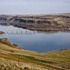
John Day Dam, Hydroelectric power station and dam on Columbia River, Oregon and Washington, United States.

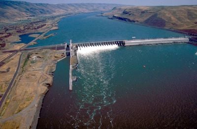
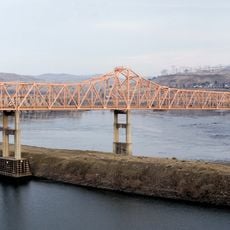
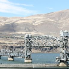
The John Day Dam stretches 1719 meters across the Columbia River, using 16 turbines that together generate 2160 megawatts of electricity for the Pacific Northwest region. A lock chamber alongside the main structure allows barges to pass through the different water levels.

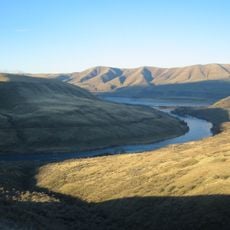
The United States Army Corps of Engineers began construction in 1959 and completed the project after twelve years of intensive work on river regulation. The construction changed the landscape between Oregon and Washington, creating a controlled waterway for navigation and power generation.

A visitor center sits one kilometer downstream, where windows open into the turbine bay and reveal the process of power generation. The place sees regional school groups during salmon runs, when families gather at observation stations to watch fish climb the ladders.

The site is accessible during daylight hours via a road along the north shore, and parking areas sit close to visitor facilities. During salmon runs in spring and autumn, viewing rooms fill quickly, so mornings tend to be less crowded.

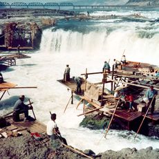
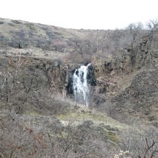
The fish ladder includes over 30 pools rising 34 meters in elevation, and video cameras record every fish that swims through. These recordings help biologists track migration patterns and population numbers without disturbing the animals.

Location: Washington

Location: Oregon

Inception: 1959

Length: 1,719 m

GPS coordinates: 45.71640,-120.69400

Latest update: December 5, 2025 22:29

Photos
Around this place
Maryhill Stonehenge
United States of America

Maryhill Stonehenge

9 km
Celilo Falls
United States of America

Celilo Falls

23.3 km
Pacific DC Intertie
United States of America

Pacific DC Intertie

35.4 km
The Dalles Dam
United States of America

The Dalles Dam

36 km
Maryhill Museum of Art
United States of America

Maryhill Museum of Art

14 km
Goldendale Observatory State Park
United States of America

Goldendale Observatory State Park

16.6 km
Cottonwood Canyon State Park
United States of America

Cottonwood Canyon State Park

31.6 km
Celilo Converter Station
United States of America

Celilo Converter Station

35.3 km
Sam Hill Memorial Bridge
United States of America

Sam Hill Memorial Bridge

11.9 km
The Dalles Bridge
United States of America

The Dalles Bridge

36.6 km
The Dalles Mint
United States of America

The Dalles Mint

39.8 km
Maryhill State Park
United States of America

Maryhill State Park

11 km
Deschutes River State Recreation Area
United States of America

Deschutes River State Recreation Area

19.2 km
Oregon Trunk Rail Bridge
United States of America

Oregon Trunk Rail Bridge

23.6 km
Columbia Hills Historical State Park
United States of America

Columbia Hills Historical State Park

31.6 km
Charles E. Nelson House
United States of America

Charles E. Nelson House

32.2 km
Columbia Hills
United States of America

Columbia Hills

7.6 km
Granada Theater
United States of America

Granada Theater

40.1 km
Goldendale Free Public Library
United States of America

Goldendale Free Public Library

15.3 km
John and Helen Moore House
United States of America

John and Helen Moore House

30.5 km
Indian Shaker Church and Gulick Homestead
United States of America

Indian Shaker Church and Gulick Homestead

36.3 km
The Dalles Civic Auditorium
United States of America

The Dalles Civic Auditorium

40.1 km
First Day Advent Christian Church
United States of America

First Day Advent Christian Church

9.8 km
The Dalles Carnegie Library
United States of America

The Dalles Carnegie Library

40.2 km
Joseph D. and Margaret Kelly House
United States of America

Joseph D. and Margaret Kelly House

39.9 km
Sharp Family Residential Ensemble
United States of America

Sharp Family Residential Ensemble

40.1 km
Sherman County Courthouse
United States of America

Sherman County Courthouse

34.6 km
Sunshine Mill
United States of America

Sunshine Mill

39.5 km
Show the full map
Reviews

Visited this place? Tap the stars to rate it and share your experience / photos with the community! Try now! You can cancel it anytime.

« John Day Dam - Hydroelectric power station and dam on Columbia River, Oregon and Washington, United States » is provided by Around Us (aroundus.com). Images and texts are derived from Wikimedia project under a Creative Commons license. You are allowed to copy, distribute, and modify copies of this page, under the conditions set by the license, as long as this note is clearly visible.

Discover hidden gems everywhere you go!

From secret cafés to breathtaking viewpoints, skip the crowded tourist spots and find places that match your style. Our app makes it easy with voice search, smart filtering, route optimization, and insider tips from travelers worldwide. Download now for the complete mobile experience.

Around Us App Screenshot

A unique approach to discovering new places

Le Figaro

All the places worth exploring

France Info

A tailor-made excursion in just a few clicks

20 Minutes