Enable Location

We need your location to show you interesting places around you

Discover nearby places

Find interesting locations and hidden gems around you

Precise directions

Get accurate directions and distances to places

Your location is never shared with other users. It's only used when you tap the location button.

Rimrock Lake

Log in to your account

Start exploring — it's free

Trusted by 62,346 travelers worldwide

Continue with Google
Continue with Apple
or

We will send you a code to connect

By continuing, you accept our Terms and Conditions and our Privacy Policy

Check your inbox

We've sent a pincode in your inbox. Please enter the code below.

Rimrock Lake

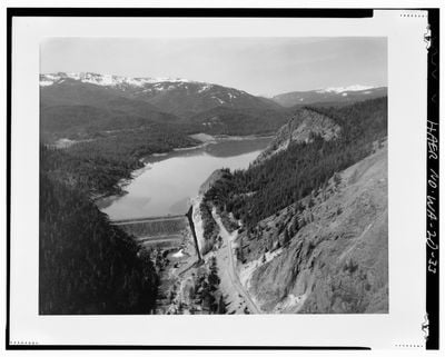
Rimrock Lake, body of water

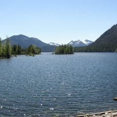
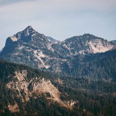
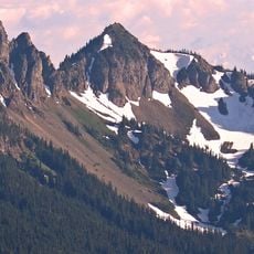
Rimrock Lake is a large reservoir in Washington with clear waters and a broad surface surrounded by forested hills and rocky slopes. The lake features campgrounds, boat ramps, docks, and fishing spots along its shoreline, serving visitors who come for fishing, boating, swimming, and outdoor relaxation.

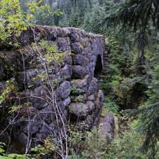
The lake was created through dam construction to manage water for regional use and support local agriculture. This infrastructure continues to shape how the reservoir functions for both irrigation and recreation today.

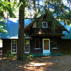
The lake is easily accessible via US-12 with signage directing visitors to parking areas, boat ramps, and picnic spots. Basic facilities including open campgrounds and boat ramps are available during most seasons throughout the year.

Between September and October, water discharge from the dam creates whitewater conditions on the Tieton River below, allowing for challenging rafting trips as the water flows faster. This seasonal window transforms the lower river into an adventure destination that differs greatly from the calm summer lake experience.

The community of curious travelers

AroundUs brings together thousands of curated places, local tips, and hidden gems, enriched daily by 60,000 contributors worldwide.

Start exploring
Location
GPS coordinates
46.65640,-121.12900
Latest update
February 7, 2026 11:40
Around this place
Goat Rocks Wilderness
United States of America

Goat Rocks Wilderness

29.6 km
Fort Simcoe
United States of America

Fort Simcoe

41.6 km
William O. Douglas Wilderness
United States of America

William O. Douglas Wilderness

21.8 km
Bumping Lake
United States of America

Bumping Lake

26.1 km
Tatoosh Wilderness
United States of America

Tatoosh Wilderness

40.1 km
Norse Peak Wilderness
United States of America

Norse Peak Wilderness

41.6 km
Gilbert Peak
United States of America

Gilbert Peak

28.3 km
Silver Falls
United States of America

Silver Falls

34.6 km
Tipsoo Lake Comfort Station
United States of America

Tipsoo Lake Comfort Station

38.1 km
Chinook Pass Entrance Arch
United States of America

Chinook Pass Entrance Arch

38 km
Packwood Glacier
United States of America

Packwood Glacier

29.7 km
Shriner Peak Fire Lookout
United States of America

Shriner Peak Fire Lookout

35.3 km
McCall Glacier
United States of America

McCall Glacier

29.3 km
Fifes Peaks
United States of America

Fifes Peaks

38.3 km
Kamiakin's Gardens
United States of America

Kamiakin's Gardens

27.2 km
Chinook Peak
United States of America

Chinook Peak

39.5 km
Three Lakes Patrol Cabin
United States of America

Three Lakes Patrol Cabin

28.9 km
La Wis Wis Guard Station No. 1165
United States of America

La Wis Wis Guard Station No. 1165

34.8 km
Dewey Peak
United States of America

Dewey Peak

34.1 km
Edgar Rock Lodge
United States of America

Edgar Rock Lodge

30.1 km
Deer Creek Bridge
United States of America

Deer Creek Bridge

35.5 km
Nickel Creek Bridge
United States of America

Nickel Creek Bridge

39.8 km
Ohanapecosh Comfort Station No. O-303
United States of America

Ohanapecosh Comfort Station No. O-303

34.6 km
Ohanapecosh Comfort Station No. O-302
United States of America

Ohanapecosh Comfort Station No. O-302

34.5 km
Ohanapecosh Campground
United States of America

Ohanapecosh Campground

34.6 km
Ohanapecosh Visitor Center
United States of America

Ohanapecosh Visitor Center

34.5 km
Ohanapecosh Campground Amphitheater
United States of America

Ohanapecosh Campground Amphitheater

34.6 km
Barrier Peak
United States of America

Barrier Peak

41 km
Show the full map
« Rimrock Lake - body of water » is provided by Around Us (aroundus.com). Images and texts are derived from Wikimedia project under a Creative Commons license. You are allowed to copy, distribute, and modify copies of this page, under the conditions set by the license, as long as this note is clearly visible.

Discover hidden gems everywhere you go!

From secret cafés to breathtaking viewpoints, skip the crowded tourist spots and find places that match your style. Our app makes it easy with voice search, smart filtering, route optimization, and insider tips from travelers worldwide. Download now for the complete mobile experience.

Around Us App Screenshot

A unique approach to discovering new places

Le Figaro

All the places worth exploring

France Info

A tailor-made excursion in just a few clicks

20 Minutes

Around Us
Travel Guide & Maps
Download

Send to your phone

QR Code
1

Open the camera app on your mobile.

2

Point at the QR code with your camera. A notification will appear.

3

Tap the notification to open the link.