Chest opened
+${chestReward.xp} XP
Explorer
NOUVEAU ×${chestReward.collectible.quantity}
tapez pour fermer
Chest locked

Open chests in the app

Around Us is built for your phone — chests unlock when you walk, explore and capture nearby places.

Enable Location

We need your location to show you interesting places around you

Discover nearby places

Find interesting locations and hidden gems around you

Precise directions

Get accurate directions and distances to places

Your location is never shared with other users. It's only used when you tap the location button.

McKittrick Tar Pits

Log in to your account

Start exploring — it's free

Trusted by 72,961 travelers worldwide

Continue with Google
Continue with Apple
or

We will send you a code to connect

By continuing, you accept our Terms and Conditions and our Privacy Policy

Check your inbox

We've sent a pincode in your inbox. Please enter the code below.

McKittrick Tar Pits
Discussion Reviews 1 Photos
13.6k Popularity

McKittrick Tar Pits, Natural asphalt lakes in Kern County, California, US

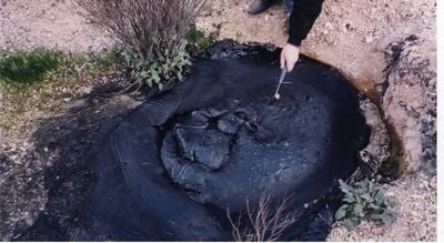
The McKittrick Tar Pits are natural asphalt lakes in Kern County that form a series of dark surface pools near Highway 58. These seeps occur where crude oil rises to the surface and solidifies into tar-like deposits.

The site attracted paleontologists in the 1920s who discovered bones of extinct animals trapped in the asphalt. The natural preservation allowed scientists to study ancient animal communities that lived in the region.

The Yokuts Native American communities used the natural asphalt from these pits for waterproofing materials and established trade networks with neighboring groups.

The tar pits sit alongside Highway 58 west of Bakersfield and are visible from the road. Access is straightforward since you can view the sites directly from the roadside.

The tar pits contain fossils dating between 26,850 and 11,160 years old, preserved in natural asphalt formed from oil reaching the surface.

The community of curious travelers

AroundUs brings together thousands of curated places, local tips, and hidden gems, enriched daily by 60,000 contributors worldwide.

Start exploring
Location
GPS coordinates
35.29500,-119.62700
Latest update
December 7, 2025 20:25
Around this place
Buck Owens Crystal Palace
United States of America

Buck Owens Crystal Palace

54 km
Painted Rock
United States of America

Painted Rock

27 km
Colonel Allensworth State Historic Park
United States of America

Colonel Allensworth State Historic Park

67.5 km
Fox Theater
United States of America

Fox Theater

55.7 km
San Rafael Wilderness
United States of America

San Rafael Wilderness

58 km
Bitter Creek National Wildlife Refuge
United States of America

Bitter Creek National Wildlife Refuge

46.7 km
Kern National Wildlife Refuge
United States of America

Kern National Wildlife Refuge

50.2 km
Chumash Wilderness
United States of America

Chumash Wilderness

66.9 km
Memorial Stadium
United States of America

Memorial Stadium

61 km
Kern County Museum
United States of America

Kern County Museum

56.2 km
The Forty Acres
United States of America

The Forty Acres

60.6 km
Wasco Union High School
United States of America

Wasco Union High School

42 km
United States of America

Antimony Peak

66.1 km
Caliente Mountain
United States of America

Caliente Mountain

31.3 km
Beale Memorial Clock Tower
United States of America

Beale Memorial Clock Tower

56.3 km
Bakersfield City Hall
United States of America

Bakersfield City Hall

55.8 km
Bakersfield Museum of Art
United States of America

Bakersfield Museum of Art

56.9 km
Bakersfield California Building
United States of America

Bakersfield California Building

55.9 km
The Fort
United States of America

The Fort

21.8 km
Buena Vista Museum of Natural History
United States of America

Buena Vista Museum of Natural History

56.1 km
Baker Branch Library
United States of America

Baker Branch Library

58.7 km
Tevis Block
United States of America

Tevis Block

55.8 km
Jastro Building
United States of America

Jastro Building

55.7 km
Shafter Research Station
United States of America

Shafter Research Station

41.2 km
Kern County Chamber of Commerce Building
United States of America

Kern County Chamber of Commerce Building

56.2 km
Kern Veterans Memorial
United States of America

Kern Veterans Memorial

56.9 km
Madulce Peak
United States of America

Madulce Peak

67.3 km
Alano Club Of Bakersfield
United States of America

Alano Club Of Bakersfield

56.8 km
Show the full map
Reviews
Share your experience

No review yet

Discussions
Start a discussion...

No discussion yet

« McKittrick Tar Pits - Natural asphalt lakes in Kern County, California, US » is provided by Around Us (aroundus.com). Images and texts are derived from Wikimedia project under a Creative Commons license. You are allowed to copy, distribute, and modify copies of this page, under the conditions set by the license, as long as this note is clearly visible.

Discover hidden gems everywhere you go!

From secret cafés to breathtaking viewpoints, skip the crowded tourist spots and find places that match your style. Our app makes it easy with voice search, smart filtering, route optimization, and insider tips from travelers worldwide. Download now for the complete mobile experience.

Around Us App Screenshot

A unique approach to discovering new places

Le Figaro

All the places worth exploring

France Info

A tailor-made excursion in just a few clicks

20 Minutes

Around Us
Travel Guide & Maps
Download

Send to your phone

QR Code
1

Open the camera app on your mobile.

2

Point at the QR code with your camera. A notification will appear.

3

Tap the notification to open the link.