·

Enable Location

We need your location to show you interesting places around you

Discover nearby places

Find interesting locations and hidden gems around you

Precise directions

Get accurate directions and distances to places

Your location is never shared with other users. It's only used when you tap the location button.

Painted Rock

Log in to your account

Start exploring — it's free

Trusted by 62,649 travelers worldwide

Continue with Google
Continue with Apple
or

We will send you a code to connect

By continuing, you accept our Terms and Conditions and our Privacy Policy

Check your inbox

We've sent a pincode in your inbox. Please enter the code below.

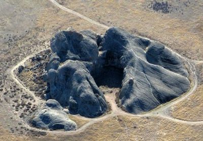
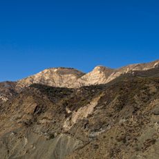
Painted Rock, Ancient pictograph site in Carrizo Plain, California.

Painted Rock is a horseshoe-shaped sandstone alcove in the Carrizo Plain with a reddish appearance. Its surface holds numerous paintings in multiple colors—red, black, white, yellow, green, and blue—layered on top of each other across the rock face.

Native Americans began painting at this location between 3,000 and 4,000 years ago. Over millennia, different tribes added their own work, and early settlers also left their marks on the rock surface in later centuries.

The rock art comes from the Chumash, Salinan, and Yokuts peoples, who expressed their spiritual beliefs through painted images on stone. These communities used simple tools and techniques that remained visible for thousands of years.

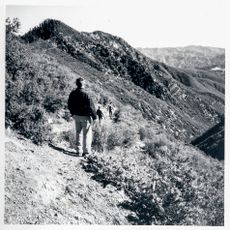
Visitors must arrange a reservation in advance to access this protected site. It is important to follow preservation guidelines and view the rock art from a safe distance without touching or damaging the surface.

The paintings show multiple layers of artwork from different eras, with each generation adding their own marks to the stone. These overlapping images let visitors see how the artistic style changed across thousands of years.

The community of curious travelers

AroundUs brings together thousands of curated places, local tips, and hidden gems, enriched daily by 60,000 contributors worldwide.

Start exploring
Location
GPS coordinates
35.14610,-119.86200
Latest update
December 8, 2025 19:51
Around this place
Neverland Ranch
United States of America

Neverland Ranch

49.2 km
Mission Santa Inés
United States of America

Mission Santa Inés

66.3 km
Knapp's Castle
United States of America

Knapp's Castle

69.6 km
Cold Spring Canyon Arch Bridge
United States of America

Cold Spring Canyon Arch Bridge

69.1 km
Figueroa Mountain
United States of America

Figueroa Mountain

46.2 km
San Rafael Wilderness
United States of America

San Rafael Wilderness

37.3 km
Bitter Creek National Wildlife Refuge
United States of America

Bitter Creek National Wildlife Refuge

51.4 km
OstrichLand USA
United States of America

OstrichLand USA

66.5 km
Santa Margarita Lake
United States of America

Santa Margarita Lake

58.9 km
Twitchell Reservoir
United States of America

Twitchell Reservoir

46 km
Lake Cachuma
United States of America

Lake Cachuma

63.2 km
Wasco Union High School
United States of America

Wasco Union High School

68.5 km
Dana Adobe
United States of America

Dana Adobe

56.8 km
Solvang Vintage Motorcycle Museum
United States of America

Solvang Vintage Motorcycle Museum

66.2 km
Bradbury Dam
United States of America

Bradbury Dam

63.6 km
Caliente Mountain
United States of America

Caliente Mountain

15.3 km
The Fort
United States of America

The Fort

36.1 km
Los Alamos Ranch House
United States of America

Los Alamos Ranch House

60.7 km
Chapel of San Ramon
United States of America

Chapel of San Ramon

47.9 km
Shafter Research Station
United States of America

Shafter Research Station

68.2 km
Little Pine Mountain
United States of America

Little Pine Mountain

61.8 km
Arroyo Grande IOOF Hall
United States of America

Arroyo Grande IOOF Hall

65.2 km
Madulce Peak
United States of America

Madulce Peak

56.4 km
Elverhøj Museum of History and Art
United States of America

Elverhøj Museum of History and Art

66.8 km
Fort Preservation Society
United States of America

Fort Preservation Society

36.1 km
Solvang Park
United States of America

Solvang Park

66.3 km
Solvang Festival Theater
United States of America

Solvang Festival Theater

66.5 km
Zaca Creek Bridge No. 1
United States of America

Zaca Creek Bridge No. 1

62.1 km
Show the full map
« Painted Rock - Ancient pictograph site in Carrizo Plain, California » is provided by Around Us (aroundus.com). Images and texts are derived from Wikimedia project under a Creative Commons license. You are allowed to copy, distribute, and modify copies of this page, under the conditions set by the license, as long as this note is clearly visible.

Discover hidden gems everywhere you go!

From secret cafés to breathtaking viewpoints, skip the crowded tourist spots and find places that match your style. Our app makes it easy with voice search, smart filtering, route optimization, and insider tips from travelers worldwide. Download now for the complete mobile experience.

Around Us App Screenshot

A unique approach to discovering new places

Le Figaro

All the places worth exploring

France Info

A tailor-made excursion in just a few clicks

20 Minutes

Around Us
Travel Guide & Maps
Download

Send to your phone

QR Code
1

Open the camera app on your mobile.

2

Point at the QR code with your camera. A notification will appear.

3

Tap the notification to open the link.