Enable Location

We need your location to show you interesting places around you

Discover nearby places

Find interesting locations and hidden gems around you

Precise directions

Get accurate directions and distances to places

Your location is never shared with other users. It's only used when you tap the location button.

Antelope Valley Indian Museum State Historic Park

Log in to your account

Start exploring — it's free

Trusted by 62,061 travelers worldwide

Continue with Google
Continue with Apple
or

We will send you a code to connect

By continuing, you accept our Terms and Conditions and our Privacy Policy

Check your inbox

We've sent a pincode in your inbox. Please enter the code below.

Antelope Valley Indian Museum State Historic Park, Ethnographic museum and California state historic park in Lancaster, United States.

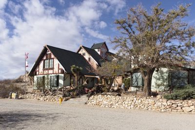
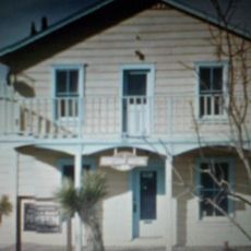
The Antelope Valley Indian Museum is an ethnographic museum and California state historic park located on Piute Butte that displays Native American artifacts from multiple regions. The building incorporates natural rock formations into its design and houses collections representing different communities and time periods.

Howard Arden Edwards, a homesteader and artist, built this folk art structure in 1928 on the desert landscape. The site was later designated a state historic park in 1979 to preserve the Native American heritage it contains.

The exhibits showcase how Native American groups from the Southwest, Great Basin, and California used tools and objects in their daily lives and ceremonies. You can see how these communities shaped the objects and practices that mattered most to them.

Joshua Cottage offers hands-on activities where you can learn about traditional food processing and fire-making techniques used by Native Americans. Wear comfortable walking shoes since you will explore different outdoor and indoor areas of the site.

Native American artists regularly demonstrate their craft techniques and perform traditional ground blessing ceremonies in the outdoor ceremonial arena. These living demonstrations show how ancestral knowledge continues to be shared and practiced in the present day.

The community of curious travelers

AroundUs brings together thousands of curated places, local tips, and hidden gems, enriched daily by 60,000 contributors worldwide.

Start exploring
Location
Inception
1979
Address
15701 East Ave. M, Lancaster, CA 93535
Phone
GPS coordinates
34.65028,-117.84889
Latest update
December 9, 2025 18:45
Around this place
Angeles National Forest
United States of America

Angeles National Forest

43.9 km
Angeles Crest Highway
United States of America

Angeles Crest Highway

35.1 km
California State Route 14
United States of America

California State Route 14

31 km
Rogers Dry Lake
United States of America

Rogers Dry Lake

30.3 km
Devil's Punchbowl
United States of America

Devil's Punchbowl

26.8 km
Crystal Lake Recreation Area
United States of America

Crystal Lake Recreation Area

36.2 km
Scaled Composites Triumph
United States of America

Scaled Composites Triumph

22.6 km
San Gabriel Mountains National Monument
United States of America

San Gabriel Mountains National Monument

36.7 km
Mount Baden-Powell
United States of America

Mount Baden-Powell

33.4 km
Joe Davies Heritage Airpark
United States of America

Joe Davies Heritage Airpark

22.6 km
Los Angeles Air Route Traffic Control Center
United States of America

Los Angeles Air Route Traffic Control Center

22.1 km
Saddleback Butte State Park
United States of America

Saddleback Butte State Park

5.3 km
Table Mountain Observatory
United States of America

Table Mountain Observatory

33.6 km
Dry Town Water Park
United States of America

Dry Town Water Park

21.9 km
Littlerock Dam
United States of America

Littlerock Dam

24.2 km
Mount Islip
United States of America

Mount Islip

34 km
Mount Burnham
United States of America

Mount Burnham

33 km
United States of America

Waterman Mountain

35.8 km
Throop Peak
United States of America

Throop Peak

33.7 km
Windy Gap Trail
United States of America

Windy Gap Trail

34.2 km
Western Hotel
United States of America

Western Hotel

27.1 km
Blackbird Airpark
United States of America

Blackbird Airpark

22.3 km
Moah:cedar
United States of America

Moah:cedar

27.1 km
Elyze Clifford Interpretive Center
United States of America

Elyze Clifford Interpretive Center

31.6 km
Century Circle
United States of America

Century Circle

27.8 km
Blackbird Airpark
United States of America

Blackbird Airpark

22.3 km
Armstrong Aircraft Operations Facility
United States of America

Armstrong Aircraft Operations Facility

21.3 km
Lockheed A-12 Blackbird monument
United States of America

Lockheed A-12 Blackbird monument

22.4 km
Show the full map
« Antelope Valley Indian Museum State Historic Park - Ethnographic museum and California state historic park in Lancaster, United States » is provided by Around Us (aroundus.com). Images and texts are derived from Wikimedia project under a Creative Commons license. You are allowed to copy, distribute, and modify copies of this page, under the conditions set by the license, as long as this note is clearly visible.

Discover hidden gems everywhere you go!

From secret cafés to breathtaking viewpoints, skip the crowded tourist spots and find places that match your style. Our app makes it easy with voice search, smart filtering, route optimization, and insider tips from travelers worldwide. Download now for the complete mobile experience.

Around Us App Screenshot

A unique approach to discovering new places

Le Figaro

All the places worth exploring

France Info

A tailor-made excursion in just a few clicks

20 Minutes

Around Us
Travel Guide & Maps
Download

Send to your phone

QR Code
1

Open the camera app on your mobile.

2

Point at the QR code with your camera. A notification will appear.

3

Tap the notification to open the link.