Chest opened
+${chestReward.xp} XP
Explorer
NOUVEAU ×${chestReward.collectible.quantity}
tapez pour fermer
Chest locked

Open chests in the app

Around Us is built for your phone — chests unlock when you walk, explore and capture nearby places.

Enable Location

We need your location to show you interesting places around you

Discover nearby places

Find interesting locations and hidden gems around you

Precise directions

Get accurate directions and distances to places

Your location is never shared with other users. It's only used when you tap the location button.

El Mirage Lake

Log in to your account

Start exploring — it's free

Trusted by 72,978 travelers worldwide

Continue with Google
Continue with Apple
or

We will send you a code to connect

By continuing, you accept our Terms and Conditions and our Privacy Policy

Check your inbox

We've sent a pincode in your inbox. Please enter the code below.

El Mirage Lake
Discussion Reviews 1 Photos
17.5k Popularity

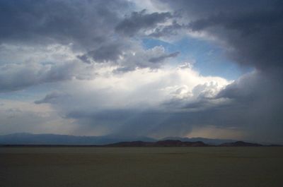
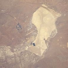
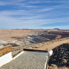
El Mirage Lake, Dry lakebed in San Bernardino County, US.

El Mirage Lake is a dry lakebed in San Bernardino County that stretches across several miles with a flat, hard clay surface. This solid ground formed from ancient silt deposits that hardened over time into a smooth racing surface.

The Southern California Timing Association has conducted speed trials on this lakebed for over five decades. These racing trials have produced numerous records and established the location as a testing ground for vehicles.

The flat expanse serves as a gathering point for recreational enthusiasts who practice land sailing, ultralight aircraft flying, and remote-controlled airplane operations. Visitors come here to test their skills in these sports against the open landscape.

Be prepared for seasonal closures during wet conditions, as moisture can damage the surface and make it unsafe. Check current conditions before planning your visit, since weather can change the accessibility of the lakebed.

The surface requires careful monitoring because vehicle use can quickly create ruts and damage if conditions are not ideal, posing safety risks. This sensitivity to traffic is why authorities close the lakebed during rainy periods to protect its integrity.

The community of curious travelers

AroundUs brings together thousands of curated places, local tips, and hidden gems, enriched daily by 60,000 contributors worldwide.

Start exploring
GPS coordinates
34.64700,-117.60001
Latest update
December 7, 2025 19:24
Around this place
Mount San Antonio
United States of America

Mount San Antonio

40.1 km
Bridge to Nowhere
United States of America

Bridge to Nowhere

42.7 km
Rogers Dry Lake
United States of America

Rogers Dry Lake

37 km
Devil's Punchbowl
United States of America

Devil's Punchbowl

34.8 km
Crystal Lake Recreation Area
United States of America

Crystal Lake Recreation Area

41.9 km
San Gabriel Mountains National Monument
United States of America

San Gabriel Mountains National Monument

44.1 km
Mount Baldy Zen Center
United States of America

Mount Baldy Zen Center

44.3 km
Mount Baden-Powell
United States of America

Mount Baden-Powell

35.5 km
Antelope Valley Indian Museum State Historic Park
United States of America

Antelope Valley Indian Museum State Historic Park

22.8 km
Saddleback Butte State Park
United States of America

Saddleback Butte State Park

18.5 km
Table Mountain Observatory
United States of America

Table Mountain Observatory

30.4 km
Dry Town Water Park
United States of America

Dry Town Water Park

43.3 km
Littlerock Dam
United States of America

Littlerock Dam

42.6 km
California Route 66 Museum
United States of America

California Route 66 Museum

30.6 km
Iron Mountain
United States of America

Iron Mountain

41.3 km
Mount Islip
United States of America

Mount Islip

40.2 km
Mount Burnham
United States of America

Mount Burnham

36.1 km
Mount Harwood
United States of America

Mount Harwood

40.2 km
Throop Peak
United States of America

Throop Peak

37.7 km
Windy Gap Trail
United States of America

Windy Gap Trail

39.8 km
Telegraph Peak
United States of America

Telegraph Peak

42.9 km
Cajon Pass
United States of America

Cajon Pass

39.1 km
Santa Fe And Salt Lake Trail Monument
United States of America

Santa Fe And Salt Lake Trail Monument

39.8 km
Mormon Trail Monument
United States of America

Mormon Trail Monument

33.6 km
Rio Tinto Borax Mine Visitor Center
United States of America

Rio Tinto Borax Mine Visitor Center

43.4 km
High Desert Lanes Bowling Center
United States of America

High Desert Lanes Bowling Center

42.4 km
Blackbird Airpark
United States of America

Blackbird Airpark

44.8 km
Century Circle
United States of America

Century Circle

43.6 km
Show the full map
Reviews
Share your experience

No review yet

Discussions
Start a discussion...

No discussion yet

« El Mirage Lake - Dry lakebed in San Bernardino County, US » is provided by Around Us (aroundus.com). Images and texts are derived from Wikimedia project under a Creative Commons license. You are allowed to copy, distribute, and modify copies of this page, under the conditions set by the license, as long as this note is clearly visible.

Discover hidden gems everywhere you go!

From secret cafés to breathtaking viewpoints, skip the crowded tourist spots and find places that match your style. Our app makes it easy with voice search, smart filtering, route optimization, and insider tips from travelers worldwide. Download now for the complete mobile experience.

Around Us App Screenshot

A unique approach to discovering new places

Le Figaro

All the places worth exploring

France Info

A tailor-made excursion in just a few clicks

20 Minutes

Around Us
Travel Guide & Maps
Download

Send to your phone

QR Code
1

Open the camera app on your mobile.

2

Point at the QR code with your camera. A notification will appear.

3

Tap the notification to open the link.