Enable Location

We need your location to show you interesting places around you

Discover nearby places

Find interesting locations and hidden gems around you

Precise directions

Get accurate directions and distances to places

Your location is never shared with other users. It's only used when you tap the location button.

Dante's View

Log in to your account

Join the adventure

Create your free account and start exploring (like 60k+ others)

We will send you a code to connect

or
Continue with Google
Continue with Apple
By continuing, you accept our Terms and Conditions and our Privacy Policy

Check your inbox

We've sent a pincode in your inbox. Please enter the code below.

Dante's View

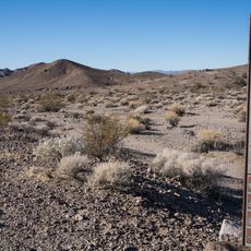
Dante's View, Mountain overlook in Death Valley National Park, US

Description

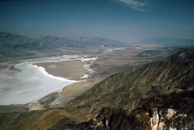
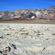
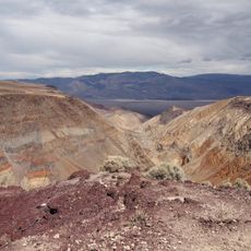
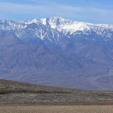
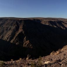
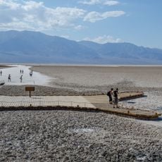
Dante's View is a mountain overlook in Death Valley National Park positioned at roughly 5,575 feet elevation, looking down onto Badwater Basin. From this vantage point, you can see the white salt flats and the Panamint Range stretching across the valley floor.

History

A local resident named Charles Brown brought this location to Nevada's governor's attention in 1926, describing it as the most remarkable viewpoint in Death Valley's mountain ranges. The name was chosen later to connect this extreme landscape with poetic themes from Dante's literary works.

Culture

The viewpoint takes its name from Dante Alighieri, the Italian poet who wrote about journeys through different realms in his Divine Comedy. This poetic naming invites visitors to reflect on the vast landscape below as a kind of earthly underworld.

Practical

Access to the overlook is via a paved road from Highway 190 that leads about 13 miles to a parking area at the summit. Interpretive exhibits at the top help explain the geology and what you are seeing across the valley.

Did you know?

The location was used as a filming site for Star Wars Episode IV, representing the Mos Eisley spaceport when characters first glimpse Tatooine. This connection to science fiction film history surprises many visitors who see the landscape only as a natural wonder.

Location
Elevation above the sea
1,669 m
GPS coordinates
36.22066,-116.72675
Latest update
December 20, 2025 12:40

AroundUs brings together thousands of curated places, local tips, and hidden gems, enriched daily by 60,000 contributors worldwide. Discover all places nearby (Inyo County).

Around this place
Death Valley
United States of America

Death Valley

29.1 km
Chicken Ranch
United States of America

Chicken Ranch

71.1 km
Devils Hole
United States of America

Devils Hole

45.2 km
Barker Ranch
United States of America

Barker Ranch

51.7 km
Rainbow Canyon
United States of America

Rainbow Canyon

72.9 km
Telescope Peak
United States of America

Telescope Peak

33 km
Amargosa Opera House and Hotel
United States of America

Amargosa Opera House and Hotel

29.4 km
Darwin Falls
United States of America

Darwin Falls

72.4 km
Ash Meadows National Wildlife Refuge
United States of America

Ash Meadows National Wildlife Refuge

43.6 km
Goldwell Open Air Museum
United States of America

Goldwell Open Air Museum

75.1 km
Spring Mountain Motorsports Ranch
United States of America

Spring Mountain Motorsports Ranch

73.4 km
Saddle Peak Hills Wilderness
United States of America

Saddle Peak Hills Wilderness

59.7 km
Saratoga Springs
United States of America

Saratoga Springs

65.9 km
Eagle Borax Works
United States of America

Eagle Borax Works

12.8 km
T&T Ranch
United States of America

T&T Ranch

39.2 km
Borax Museum
United States of America

Borax Museum

29.1 km
Jubilee Pass
United States of America

Jubilee Pass

37 km
Father Crowley Viewpoint
United States of America

Father Crowley Viewpoint

74.6 km
Salsberry Pass
United States of America

Salsberry Pass

42.3 km
Beatty Museum & Historical Society
United States of America

Beatty Museum & Historical Society

76.4 km
Furnace Creek Visitor Center
United States of America

Furnace Creek Visitor Center

29.6 km
Mesquite Flat Sand Dunes
United States of America

Mesquite Flat Sand Dunes

59 km
Old Stovepipe Wells
United States of America

Old Stovepipe Wells

58.1 km
Gold Town Casino
United States of America

Gold Town Casino

66.8 km
Stovepipe Wells Campground
United States of America

Stovepipe Wells Campground

57.3 km
Beatty Museum
United States of America

Beatty Museum

76.3 km
Badwater Observation Point
United States of America

Badwater Observation Point

3.8 km
Death Valley Junction Historic District
United States of America

Death Valley Junction Historic District

29.4 km
Show the full map
« Dante's View - Mountain overlook in Death Valley National Park, US » is provided by Around Us (aroundus.com). Images and texts are derived from Wikimedia project under a Creative Commons license. You are allowed to copy, distribute, and modify copies of this page, under the conditions set by the license, as long as this note is clearly visible.

Discover hidden gems everywhere you go!

From secret cafés to breathtaking viewpoints, skip the crowded tourist spots and find places that match your style. Our app makes it easy with voice search, smart filtering, route optimization, and insider tips from travelers worldwide. Download now for the complete mobile experience.

Around Us App Screenshot

A unique approach to discovering new places

Le Figaro

All the places worth exploring

France Info

A tailor-made excursion in just a few clicks

20 Minutes

Around Us
Travel Guide & Maps
Download

Send to your phone

QR Code
1

Open the camera app on your mobile.

2

Point at the QR code with your camera. A notification will appear.

3

Tap the notification to open the link.