Chest opened
+${chestReward.xp} XP
Explorer
NOUVEAU ×${chestReward.collectible.quantity}
tapez pour fermer
Chest locked

Open chests in the app

Around Us is built for your phone — chests unlock when you walk, explore and capture nearby places.

Enable Location

We need your location to show you interesting places around you

Discover nearby places

Find interesting locations and hidden gems around you

Precise directions

Get accurate directions and distances to places

Your location is never shared with other users. It's only used when you tap the location button.

Davis Dam

Log in to your account

Start exploring — it's free

Trusted by 72,887 travelers worldwide

Continue with Google
Continue with Apple
or

We will send you a code to connect

By continuing, you accept our Terms and Conditions and our Privacy Policy

Check your inbox

We've sent a pincode in your inbox. Please enter the code below.

Discussion Reviews 1 Photos
14.3k Popularity

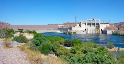
Davis Dam, Embankment dam and hydroelectric station in Mohave County, Arizona.

Davis Dam is a 488-meter embankment across the Colorado River that stores water in Lake Mohave. Five turbines use the water's flow to generate electricity for communities throughout the Southwest.

Construction started in 1942 and finished in 1951 as part of an effort to manage water and power across the Southwest. The project followed an earlier dam built downstream, creating a system of water control along the river.

The dam was named after Arthur Powell Davis, a director of the U.S. Bureau of Reclamation, reflecting its importance in American water management. The lake it created has become central to how people in the region use water and spend their free time.

The visitor area at the dam offers good views and educational displays about power generation. The site is accessible by car, and spring and fall offer more comfortable weather for spending time outdoors.

The facility manages water that arrives from another dam upstream and releases it carefully to meet water commitments to Mexico. This role in cross-border water management makes it less visible than it should be to most visitors.

The community of curious travelers

AroundUs brings together thousands of curated places, local tips, and hidden gems, enriched daily by 60,000 contributors worldwide.

Start exploring
Location
Inception
1942
Length
488 m
GPS coordinates
35.19876,-114.56949
Latest update
December 7, 2025 20:22
Around this place
Castle Mountains National Monument
United States of America

Castle Mountains National Monument

46.4 km
Atchison, Topeka and Santa Fe Railway 3759
United States of America

Atchison, Topeka and Santa Fe Railway 3759

46.5 km
Grapevine Canyon Petroglyphs
United States of America

Grapevine Canyon Petroglyphs

11.1 km
Havasu National Wildlife Refuge
United States of America

Havasu National Wildlife Refuge

46 km
Spirit Mountain
United States of America

Spirit Mountain

16.4 km
AT&T Building
United States of America

AT&T Building

46.9 km
Dead Mountains
United States of America

Dead Mountains

27.4 km
Spirit Mountain Wilderness
United States of America

Spirit Mountain Wilderness

10 km
Warm Springs Wilderness
United States of America

Warm Springs Wilderness

41.2 km
United States of America

Bridge Canyon Wilderness

12.1 km
Boundary Cone
United States of America

Boundary Cone

27.7 km
Hardyville Cemetery
United States of America

Hardyville Cemetery

8.8 km
Grapevine Canyon
United States of America

Grapevine Canyon

11.1 km
United States of America

Alexey W. Von Schmidt

22.2 km
Mohave County Courthouse and Jail
United States of America

Mohave County Courthouse and Jail

47.1 km
Mohave Museum of History and Arts
United States of America

Mohave Museum of History and Arts

46.2 km
Saint Mary's Catholic Church
United States of America

Saint Mary's Catholic Church

47 km
Kingman Commercial Historic District
United States of America

Kingman Commercial Historic District

47.1 km
G. H. Sullivan Lodging House
United States of America

G. H. Sullivan Lodging House

46.9 km
Tyrell House
United States of America

Tyrell House

46.5 km
Mohave County Hospital
United States of America

Mohave County Hospital

46.4 km
Oatman Drug Company Building
United States of America

Oatman Drug Company Building

25.7 km
House at 105 Spring St.
United States of America

House at 105 Spring St.

46.6 km
Foster S. Dennis House
United States of America

Foster S. Dennis House

46.7 km
Little Red School
United States of America

Little Red School

47.1 km
House at 809 Grand View
United States of America

House at 809 Grand View

46.3 km
J. B. Wright House
United States of America

J. B. Wright House

47 km
W. P. Mahoney House
United States of America

W. P. Mahoney House

46.8 km
Show the full map
Reviews
Share your experience

No review yet

Discussions
Start a discussion...

No discussion yet

« Davis Dam - Embankment dam and hydroelectric station in Mohave County, Arizona » is provided by Around Us (aroundus.com). Images and texts are derived from Wikimedia project under a Creative Commons license. You are allowed to copy, distribute, and modify copies of this page, under the conditions set by the license, as long as this note is clearly visible.

Discover hidden gems everywhere you go!

From secret cafés to breathtaking viewpoints, skip the crowded tourist spots and find places that match your style. Our app makes it easy with voice search, smart filtering, route optimization, and insider tips from travelers worldwide. Download now for the complete mobile experience.

Around Us App Screenshot

A unique approach to discovering new places

Le Figaro

All the places worth exploring

France Info

A tailor-made excursion in just a few clicks

20 Minutes

Around Us
Travel Guide & Maps
Download

Send to your phone

QR Code
1

Open the camera app on your mobile.

2

Point at the QR code with your camera. A notification will appear.

3

Tap the notification to open the link.