Enable Location

We need your location to show you interesting places around you

Discover nearby places

Find interesting locations and hidden gems around you

Precise directions

Get accurate directions and distances to places

Your location is never shared with other users. It's only used when you tap the location button.

High Schells Wilderness

Log in to your account

Start exploring — it's free

Trusted by 62,840 travelers worldwide

Continue with Google
Continue with Apple
or

We will send you a code to connect

By continuing, you accept our Terms and Conditions and our Privacy Policy

Check your inbox

We've sent a pincode in your inbox. Please enter the code below.

High Schells Wilderness

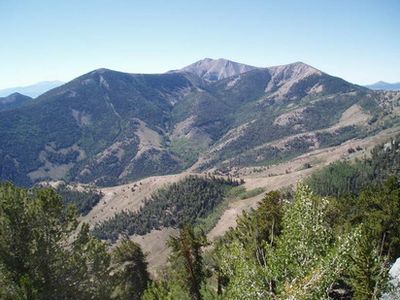
High Schells Wilderness, Protected wilderness area in White Pine County, Nevada.

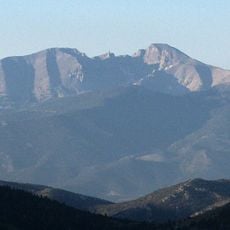
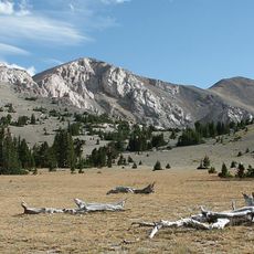
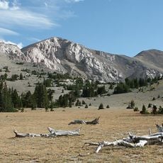
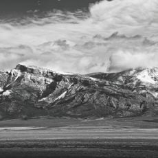
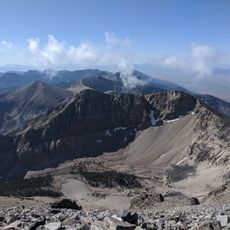
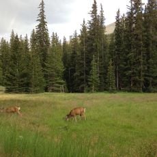
High Schells Wilderness is a protected mountain area in the Schell Creek Range with peaks that range from about 5,800 to 11,000 feet (1,770 to 3,350 meters) in elevation. The landscape features steep slopes, ridges, and valleys with changing vegetation as you climb higher.

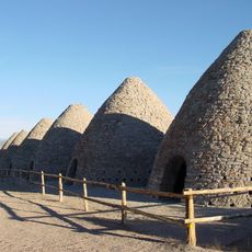
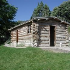
Native American groups hunted and gathered across this land for generations before mining activity began in the late 1800s. The shift from traditional hunting and gathering to extracting minerals changed how people used these mountains.

Evidence of long occupation appears in petroglyphs and stone tools scattered across the landscape, telling the story of people who made their lives in these mountains. These traces show how inhabitants moved through and used the terrain.

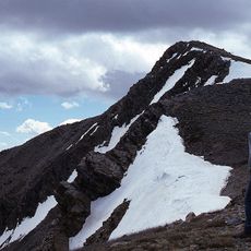
Several hiking trails wind through the protected area, including a route to North Schell Peak that climbs through different mountain zones. The best time to visit is from late spring through early fall when snow is less likely on the higher trails.

The area protects rare bristlecone pines, some of the oldest living trees on Earth. Perennial mountain streams running through the valleys support four different trout species in cool waters.

The community of curious travelers

AroundUs brings together thousands of curated places, local tips, and hidden gems, enriched daily by 60,000 contributors worldwide.

Start exploring
Location
GPS coordinates
39.33990,-114.59900
Latest update
December 13, 2025 17:02
Around this place
Ely State Prison
United States of America

Ely State Prison

29.6 km
Wheeler Peak
United States of America

Wheeler Peak

46.5 km
Ward Charcoal Ovens State Historic Park
United States of America

Ward Charcoal Ovens State Historic Park

39.9 km
Nevada Northern Railway Museum
United States of America

Nevada Northern Railway Museum

24.9 km
Hotel Nevada and Gambling Hall
United States of America

Hotel Nevada and Gambling Hall

27.3 km
Wheeler Peak Glacier
United States of America

Wheeler Peak Glacier

46.5 km
Cave Lake State Park
United States of America

Cave Lake State Park

19.8 km
Mount Moriah
United States of America

Mount Moriah

35.3 km
Mount Moriah Wilderness
United States of America

Mount Moriah Wilderness

35.3 km
North Schell Peak
United States of America

North Schell Peak

8.2 km
Central Theatre
United States of America

Central Theatre

26.3 km
Johnson Lake Mine Historic District
United States of America

Johnson Lake Mine Historic District

51.4 km
Ely L.D.S. Stake Tabernacle
United States of America

Ely L.D.S. Stake Tabernacle

26.9 km
Lehman Orchard and Aqueduct
United States of America

Lehman Orchard and Aqueduct

49.6 km
Capital Theatre
United States of America

Capital Theatre

27.4 km
Baker Ranger Station
United States of America

Baker Ranger Station

54.7 km
Rhodes Cabin
United States of America

Rhodes Cabin

49.5 km
White Pine County Courthouse
United States of America

White Pine County Courthouse

26.9 km
Bahsahwahbee
United States of America

Bahsahwahbee

25.7 km
Pyramid Peak
United States of America

Pyramid Peak

50.9 km
Lehman Caves
United States of America

Lehman Caves

49.5 km
Baker Peak
United States of America

Baker Peak

47.8 km
Nevada Northern Railway East Ely Yards and Shops
United States of America

Nevada Northern Railway East Ely Yards and Shops

24.9 km
East Ely Depot
United States of America

East Ely Depot

24.9 km
Lehman Caves Visitor Center
United States of America

Lehman Caves Visitor Center

49.6 km
Ward Charcoal Ovens
United States of America

Ward Charcoal Ovens

40 km
Great Basin Visitor Center
United States of America

Great Basin Visitor Center

54.5 km
Wheeler Peak Campground
United States of America

Wheeler Peak Campground

44.7 km
Show the full map
« High Schells Wilderness - Protected wilderness area in White Pine County, Nevada » is provided by Around Us (aroundus.com). Images and texts are derived from Wikimedia project under a Creative Commons license. You are allowed to copy, distribute, and modify copies of this page, under the conditions set by the license, as long as this note is clearly visible.

Discover hidden gems everywhere you go!

From secret cafés to breathtaking viewpoints, skip the crowded tourist spots and find places that match your style. Our app makes it easy with voice search, smart filtering, route optimization, and insider tips from travelers worldwide. Download now for the complete mobile experience.

Around Us App Screenshot

A unique approach to discovering new places

Le Figaro

All the places worth exploring

France Info

A tailor-made excursion in just a few clicks

20 Minutes

Around Us
Travel Guide & Maps
Download

Send to your phone

QR Code
1

Open the camera app on your mobile.

2

Point at the QR code with your camera. A notification will appear.

3

Tap the notification to open the link.