Enable Location

We need your location to show you interesting places around you

Discover nearby places

Find interesting locations and hidden gems around you

Precise directions

Get accurate directions and distances to places

Your location is never shared with other users. It's only used when you tap the location button.

Amistad Gymnasium

Log in to your account

Start exploring — it's free

Trusted by 62,492 travelers worldwide

Continue with Google
Continue with Apple
or

We will send you a code to connect

By continuing, you accept our Terms and Conditions and our Privacy Policy

Check your inbox

We've sent a pincode in your inbox. Please enter the code below.

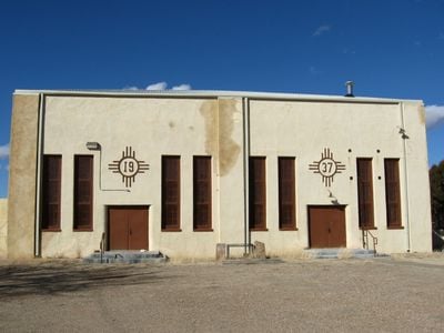
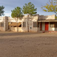
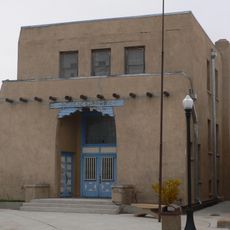
Amistad Gymnasium, community center in Amistad, New Mexico, USA

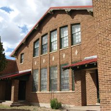
Amistad Gymnasium is a single-story building in Union County with thick stucco walls in earth tones and a metal roof that blends Pueblo Revival and Art Deco elements. The interior is designed for sports events and gatherings, featuring large windows for light and ventilation plus a steam heating system to maintain comfortable temperatures.

The building was constructed in 1937 as part of the Works Progress Administration, a government program during the Great Depression that created jobs and supported communities. In 1955 a school was built next to the gymnasium, which then used the facility for school sports and activities, further embedding it in local life.

The building displays two gold Zia sun symbols on its front, which originate from the local Zia people and represent the four seasons and stages of life. These same symbols appear on the New Mexico state flag, showing how local artistic traditions were woven into the structure.

The building sits about half a mile east of NM Road 402 and is straightforward to locate if you follow the main road. Keep in mind that this is an active community facility that may have limited visiting hours, and the structure can be affected by local weather conditions.

The gold Zia sun symbols on the facade were originally designed to encode the building's construction year of 1937, a subtle way to weave history directly into the architectural design. This hidden artistic detail is often overlooked but becomes a fascinating discovery for attentive visitors.

The community of curious travelers

AroundUs brings together thousands of curated places, local tips, and hidden gems, enriched daily by 60,000 contributors worldwide.

Start exploring
Location
Inception
1937
Architects
Works Progress Administration
Architectural style
Pueblo Revival Style architecture, Art Deco architecture
GPS coordinates
35.91926,-103.15491
Latest update
February 9, 2026 07:41
Around this place
Blue Swallow Motel
United States of America

Blue Swallow Motel

97.5 km
Rita Blanca National Grassland
United States of America

Rita Blanca National Grassland

76 km
Tucumcari Mountain
United States of America

Tucumcari Mountain

100.3 km
Sierra Grande
United States of America

Sierra Grande

108.9 km
Black Mesa State Park
United States of America

Black Mesa State Park

106.1 km
Rabbit Ears
United States of America

Rabbit Ears

75.2 km
Clayton Lake State Park
United States of America

Clayton Lake State Park

74.6 km
Texhomex
United States of America

Texhomex

66.1 km
Conchas Dam
United States of America

Conchas Dam

109.9 km
Cactus Motor Lodge
United States of America

Cactus Motor Lodge

97.3 km
Cimarron County Courthouse
United States of America

Cimarron County Courthouse

107 km
Eklund Hotel
United States of America

Eklund Hotel

59.3 km
Luna Theater
United States of America

Luna Theater

59.3 km
Clayton Public Library
United States of America

Clayton Public Library

59.2 km
Metropolitan Park Bathhouse and Pool Historic District
United States of America

Metropolitan Park Bathhouse and Pool Historic District

104.1 km
Odeon Theatre
United States of America

Odeon Theatre

97.2 km
Gate, Fence and Hollow Tree Shelter Designed by Dionicio Rodriguez
United States of America

Gate, Fence and Hollow Tree Shelter Designed by Dionicio Rodriguez

59.2 km
Nara Visa School
United States of America

Nara Visa School

34.3 km
Baca-Goodman House
United States of America

Baca-Goodman House

97.5 km
Union County Courthouse
United States of America

Union County Courthouse

59.1 km
Clayton Public Schools Historic District
United States of America

Clayton Public Schools Historic District

59.2 km
Arch Hurley Conservancy District Office Building
United States of America

Arch Hurley Conservancy District Office Building

97.5 km
Dallam County Courthouse
United States of America

Dallam County Courthouse

59.2 km
Eklund Hotel Historic Site
United States of America

Eklund Hotel Historic Site

59.3 km
Tucumcari Railroad Museum
United States of America

Tucumcari Railroad Museum

97.2 km
XIT Museum
United States of America

XIT Museum

59.1 km
Princess Theatre
United States of America

Princess Theatre

96.9 km
Mission Theater
United States of America

Mission Theater

59.1 km
Show the full map
« Amistad Gymnasium - community center in Amistad, New Mexico, USA » is provided by Around Us (aroundus.com). Images and texts are derived from Wikimedia project under a Creative Commons license. You are allowed to copy, distribute, and modify copies of this page, under the conditions set by the license, as long as this note is clearly visible.

Discover hidden gems everywhere you go!

From secret cafés to breathtaking viewpoints, skip the crowded tourist spots and find places that match your style. Our app makes it easy with voice search, smart filtering, route optimization, and insider tips from travelers worldwide. Download now for the complete mobile experience.

Around Us App Screenshot

A unique approach to discovering new places

Le Figaro

All the places worth exploring

France Info

A tailor-made excursion in just a few clicks

20 Minutes

Around Us
Travel Guide & Maps
Download

Send to your phone

QR Code
1

Open the camera app on your mobile.

2

Point at the QR code with your camera. A notification will appear.

3

Tap the notification to open the link.