Enable Location

We need your location to show you interesting places around you

Discover nearby places

Find interesting locations and hidden gems around you

Precise directions

Get accurate directions and distances to places

Your location is never shared with other users. It's only used when you tap the location button.

Sierra Grande

Log in to your account

Start exploring — it's free

Trusted by 64,528 travelers worldwide

Continue with Google
Continue with Apple
or

We will send you a code to connect

By continuing, you accept our Terms and Conditions and our Privacy Policy

Check your inbox

We've sent a pincode in your inbox. Please enter the code below.

Sierra Grande
Discussion Reviews 1 Photos
6.8k Popularity

Sierra Grande, Mountain summit in New Mexico, US

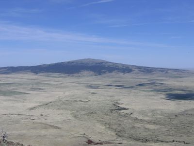
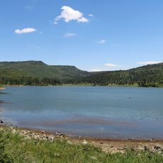
Sierra Grande is a mountain summit in northeastern New Mexico, rising to about 11,100 feet (3,380 m) above sea level. Its top is notably flat, and because it rises alone from the surrounding grassland, its shape stands out clearly from far away.

Sierra Grande is an extinct volcano whose eruptions shaped the flat-topped form that can be seen today. The lava flows and volcanic rock that spread across the area are still visible and give the surrounding land its particular look.

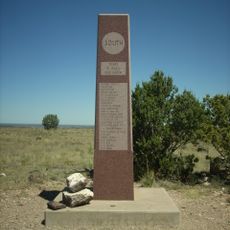
The mountain held sacred importance for Pueblo peoples who performed traditional ceremonies at its summit, viewing the location as spiritually significant.

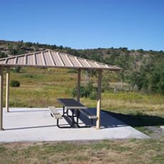
The route crosses open terrain with little shade, so sturdy footwear and enough water are a must. Setting off in the morning is a good idea because afternoon thunderstorms are common in this part of New Mexico.

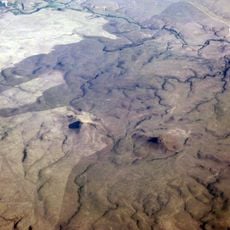
Sierra Grande is the largest extinct shield volcano in the area, and its full size is really only clear when seen from the air. On a clear day, the view from the top reaches as far as Colorado and Texas.

The community of curious travelers

AroundUs brings together thousands of curated places, local tips, and hidden gems, enriched daily by 60,000 contributors worldwide.

Start exploring
Location
GPS coordinates
36.70559,-103.87667
Latest update
March 3, 2026 10:10
Around this place
Black Mesa
United States of America

Black Mesa

63.1 km
Raton Pass
United States of America

Raton Pass

63 km
Folsom Site
United States of America

Folsom Site

26.2 km
Sugarite Canyon State Park
United States of America

Sugarite Canyon State Park

53.4 km
Rabbit Ears
United States of America

Rabbit Ears

59.6 km
Clayton Lake State Park
United States of America

Clayton Lake State Park

52.9 km
Raton Mesa
United States of America

Raton Mesa

59.2 km
Raton Downtown Historic District
United States of America

Raton Downtown Historic District

54.6 km
Trinchera Cave Archeological District
United States of America

Trinchera Cave Archeological District

52.7 km
Maxwell National Wildlife Refuge
United States of America

Maxwell National Wildlife Refuge

64.5 km
United States of America

Folsom Falls

18.6 km
Eklund Hotel
United States of America

Eklund Hotel

68 km
Luna Theater
United States of America

Luna Theater

68 km
Clayton Public Library
United States of America

Clayton Public Library

68.2 km
St. John's Methodist Episcopal Church
United States of America

St. John's Methodist Episcopal Church

37.4 km
Colfax County Courthouse
United States of America

Colfax County Courthouse

54.9 km
Folsom Hotel
United States of America

Folsom Hotel

15.9 km
Gate, Fence and Hollow Tree Shelter Designed by Dionicio Rodriguez
United States of America

Gate, Fence and Hollow Tree Shelter Designed by Dionicio Rodriguez

68.5 km
Union County Courthouse
United States of America

Union County Courthouse

67.9 km
Clayton Public Schools Historic District
United States of America

Clayton Public Schools Historic District

68.7 km
Eklund Hotel Historic Site
United States of America

Eklund Hotel Historic Site

68 km
Goodson Memorial School
United States of America

Goodson Memorial School

73.9 km
El Raton Theatre
United States of America

El Raton Theatre

54.7 km
Columbian School
United States of America

Columbian School

54.9 km
Longfellow School
United States of America

Longfellow School

54.1 km
Original Townsite Historic District
United States of America

Original Townsite Historic District

54.9 km
Ludlow Monument
United States of America

Ludlow Monument

34.6 km
Raton Museum
United States of America

Raton Museum

54.8 km
Show the full map
Reviews
Share your experience

No review yet

Discussions
Start a discussion...

No discussion yet

« Sierra Grande - Mountain summit in New Mexico, US » is provided by Around Us (aroundus.com). Images and texts are derived from Wikimedia project under a Creative Commons license. You are allowed to copy, distribute, and modify copies of this page, under the conditions set by the license, as long as this note is clearly visible.

Discover hidden gems everywhere you go!

From secret cafés to breathtaking viewpoints, skip the crowded tourist spots and find places that match your style. Our app makes it easy with voice search, smart filtering, route optimization, and insider tips from travelers worldwide. Download now for the complete mobile experience.

Around Us App Screenshot

A unique approach to discovering new places

Le Figaro

All the places worth exploring

France Info

A tailor-made excursion in just a few clicks

20 Minutes

Around Us
Travel Guide & Maps
Download

Send to your phone

QR Code
1

Open the camera app on your mobile.

2

Point at the QR code with your camera. A notification will appear.

3

Tap the notification to open the link.