Enable Location

We need your location to show you interesting places around you

Discover nearby places

Find interesting locations and hidden gems around you

Precise directions

Get accurate directions and distances to places

Your location is never shared with other users. It's only used when you tap the location button.

Cimarron County Courthouse

Log in to your account

Start exploring — it's free

Trusted by 63,424 travelers worldwide

Continue with Google
Continue with Apple
or

We will send you a code to connect

By continuing, you accept our Terms and Conditions and our Privacy Policy

Check your inbox

We've sent a pincode in your inbox. Please enter the code below.

Discussion Reviews 1 Photos
2k Popularity

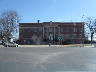
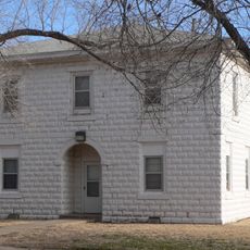
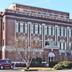
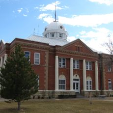
Cimarron County Courthouse, County courthouse and National Register of Historic Places site in Boise City, Oklahoma.

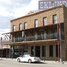
The Cimarron County Courthouse is an administrative building in Boise City featuring Neoclassical architectural details and red brick construction. The two-story structure sits at the center of town and houses local government offices and departments handling legal and property records.

The current building was constructed in 1926 after the previous wooden structure was destroyed by fire in 1925. It gained National Register of Historic Places status in 1984, recognizing its significance to the region's architectural history.

The building reflects architectural traditions that were typical in early 20th-century Oklahoma, with classical elements expressing confidence in public institutions. Visitors can see how the solid construction and design underscore the place's importance as a center of local governance.

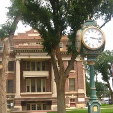
The building can be viewed and photographed from outside, with its exterior easily accessible from the central plaza. It is best visited during daylight hours when light highlights the red brick facade and architectural details.

In 1943, U.S. Army Air Forces accidentally dropped practice bombs near the building during a training mission, and one failed to explode. This unexploded bomb is preserved today as a reminder of an unusual World War II moment in the region.

The community of curious travelers

AroundUs brings together thousands of curated places, local tips, and hidden gems, enriched daily by 60,000 contributors worldwide.

Start exploring
Location
GPS coordinates
36.72972,-102.51250
Latest update
December 14, 2025 11:03
Around this place
Black Mesa
United States of America

Black Mesa

83.9 km
Rita Blanca National Grassland
United States of America

Rita Blanca National Grassland

33.8 km
Black Mesa State Park
United States of America

Black Mesa State Park

35.2 km
Rabbit Ears
United States of America

Rabbit Ears

65.4 km
Clayton Lake State Park
United States of America

Clayton Lake State Park

72.8 km
Picture Canyon
United States of America

Picture Canyon

37.6 km
Texhomex
United States of America

Texhomex

50.6 km
8 Mile Corner
United States of America

8 Mile Corner

51.1 km
Eklund Hotel
United States of America

Eklund Hotel

67.6 km
Point of Rocks
United States of America

Point of Rocks

65.9 km
Luna Theater
United States of America

Luna Theater

67.6 km
Clayton Public Library
United States of America

Clayton Public Library

67.5 km
Franklin Hall
United States of America

Franklin Hall

79.7 km
Amistad Gymnasium
United States of America

Amistad Gymnasium

107 km
Gate, Fence and Hollow Tree Shelter Designed by Dionicio Rodriguez
United States of America

Gate, Fence and Hollow Tree Shelter Designed by Dionicio Rodriguez

67.2 km
Springfield Schoolhouse
United States of America

Springfield Schoolhouse

76 km
Stonington First Methodist-Episcopal Church
United States of America

Stonington First Methodist-Episcopal Church

69.2 km
Texas County Courthouse
United States of America

Texas County Courthouse

92.2 km
Union County Courthouse
United States of America

Union County Courthouse

67.9 km
Clayton Public Schools Historic District
United States of America

Clayton Public Schools Historic District

67 km
Morton County WPA Bridge
United States of America

Morton County WPA Bridge

85.3 km
Dallam County Courthouse
United States of America

Dallam County Courthouse

74.4 km
Hooker Woodframe Grain Elevator
United States of America

Hooker Woodframe Grain Elevator

117 km
Eklund Hotel Historic Site
United States of America

Eklund Hotel Historic Site

67.6 km
Goodson Memorial School
United States of America

Goodson Memorial School

55.7 km
XIT Museum
United States of America

XIT Museum

74.4 km
Mission Theater
United States of America

Mission Theater

74.4 km
Meyer's Pumpkin Patch & Corn Maze
United States of America

Meyer's Pumpkin Patch & Corn Maze

77.9 km
Show the full map
Reviews
Share your experience

No review yet

Discussions
Start a discussion...

No discussion yet

« Cimarron County Courthouse - County courthouse and National Register of Historic Places site in Boise City, Oklahoma » is provided by Around Us (aroundus.com). Images and texts are derived from Wikimedia project under a Creative Commons license. You are allowed to copy, distribute, and modify copies of this page, under the conditions set by the license, as long as this note is clearly visible.

Discover hidden gems everywhere you go!

From secret cafés to breathtaking viewpoints, skip the crowded tourist spots and find places that match your style. Our app makes it easy with voice search, smart filtering, route optimization, and insider tips from travelers worldwide. Download now for the complete mobile experience.

Around Us App Screenshot

A unique approach to discovering new places

Le Figaro

All the places worth exploring

France Info

A tailor-made excursion in just a few clicks

20 Minutes

Around Us
Travel Guide & Maps
Download

Send to your phone

QR Code
1

Open the camera app on your mobile.

2

Point at the QR code with your camera. A notification will appear.

3

Tap the notification to open the link.