Enable Location

We need your location to show you interesting places around you

Discover nearby places

Find interesting locations and hidden gems around you

Precise directions

Get accurate directions and distances to places

Your location is never shared with other users. It's only used when you tap the location button.

Manitou Incline

Log in to your account

Join the adventure

Create your free account and start exploring (like 60k+ others)

We will send you a code to connect

or
Continue with Google
Continue with Apple
By continuing, you accept our Terms and Conditions and our Privacy Policy

Check your inbox

We've sent a pincode in your inbox. Please enter the code below.

Manitou Incline

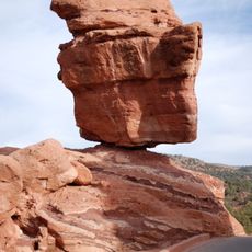
Manitou Incline, Rail trail in Manitou Springs, Colorado, US.

Description

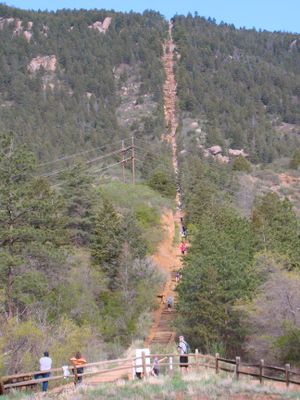
The Manitou Incline is a hiking trail on the eastern face of Rocky Mountain in Colorado, rising more than 2,700 wooden steps across less than a mile. The route follows the old railbed of a former funicular and climbs through pine forest to an open summit area overlooking Manitou Springs.

History

The site opened in 1907 as a cable railway carrying materials to water tanks on the mountain and operated until 1990. After a rockslide closed the line, it remained unused for years before reopening as a public hiking route in 2013.

Culture

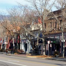
The name Incline comes from the steep slope that once carried a funicular and now draws athletes from across the country. On weekends you see groups of runners timing their ascent and cheering each other on, while others climb slowly step by step.

Practical

A reservation system limits daily visitor numbers, and booking should be made several days ahead. The descent follows the Barr Trail, a longer but gentler path that ends east of the starting point.

Did you know?

The steepest sections reach a grade of sixty-eight percent, making this one of the most demanding ascents in North America. Some steps are so high and narrow that hikers use their hands for balance.

Location
GPS coordinates
38.85680,-104.93200
Latest update
December 12, 2025 20:55

AroundUs brings together thousands of curated places, local tips, and hidden gems, enriched daily by 60,000 contributors worldwide. Discover all places nearby (Colorado).

Around this place
Garden of the Gods
United States of America

Garden of the Gods

5.8 km
Manitou Cliff Dwellings
United States of America

Manitou Cliff Dwellings

1.9 km
Cave of the Winds
United States of America

Cave of the Winds

2 km
Old Colorado City
United States of America

Old Colorado City

6 km
Glen Eyrie
United States of America

Glen Eyrie

5.7 km
Miramont Castle
United States of America

Miramont Castle

911 m
Manitou Cliff Dwellings
United States of America

Manitou Cliff Dwellings

1.8 km
Manitou Mineral Springs
United States of America

Manitou Mineral Springs

960 m
Rainbow Falls
United States of America

Rainbow Falls

1.6 km
The Broadmoor Manitou and Pikes Peak Cog Railway
United States of America

The Broadmoor Manitou and Pikes Peak Cog Railway

124 m
Manitou Springs Historic District
United States of America

Manitou Springs Historic District

960 m
Rock Ledge Ranch Historic Site
United States of America

Rock Ledge Ranch Historic Site

5.5 km
Cliff House (Manitou Springs, Colorado)
United States of America

Cliff House (Manitou Springs, Colorado)

1.3 km
Briarhurst
United States of America

Briarhurst

2.5 km
Balanced Rock
United States of America

Balanced Rock

3.2 km
Steamboat Rock
United States of America

Steamboat Rock

3.2 km
Barker House (Manitou Springs, Colorado)
United States of America

Barker House (Manitou Springs, Colorado)

1.3 km
Crystal Valley Cemetery
United States of America

Crystal Valley Cemetery

2.6 km
Manitou Bathhouse
United States of America

Manitou Bathhouse

1.3 km
Eastholme
United States of America

Eastholme

5.6 km
First Congregational Church
United States of America

First Congregational Church

1.6 km
Stockbridge House
United States of America

Stockbridge House

5.7 km
Wheeler Bank
United States of America

Wheeler Bank

1.5 km
Bridge over Fountain Creek
United States of America

Bridge over Fountain Creek

1.9 km
Second Midland School
United States of America

Second Midland School

6 km
Bridge over Fountain Creek
United States of America

Bridge over Fountain Creek

1.6 km
Keithley Log Cabin Development District
United States of America

Keithley Log Cabin Development District

2.8 km
City Hall of Old Colorado City
United States of America

City Hall of Old Colorado City

5.5 km
Show the full map
« Manitou Incline - Rail trail in Manitou Springs, Colorado, US » is provided by Around Us (aroundus.com). Images and texts are derived from Wikimedia project under a Creative Commons license. You are allowed to copy, distribute, and modify copies of this page, under the conditions set by the license, as long as this note is clearly visible.

Discover hidden gems everywhere you go!

From secret cafés to breathtaking viewpoints, skip the crowded tourist spots and find places that match your style. Our app makes it easy with voice search, smart filtering, route optimization, and insider tips from travelers worldwide. Download now for the complete mobile experience.

Around Us App Screenshot

A unique approach to discovering new places

Le Figaro

All the places worth exploring

France Info

A tailor-made excursion in just a few clicks

20 Minutes

Around Us
Travel Guide & Maps
Download

Send to your phone

QR Code
1

Open the camera app on your mobile.

2

Point at the QR code with your camera. A notification will appear.

3

Tap the notification to open the link.